Property Record
5570 Old Ranch Rd, Oceanside, CA 92057
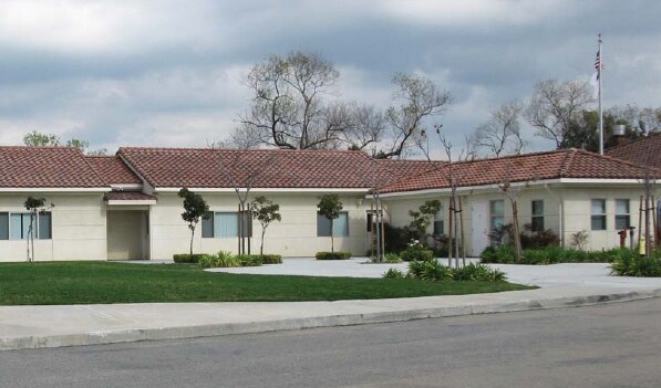

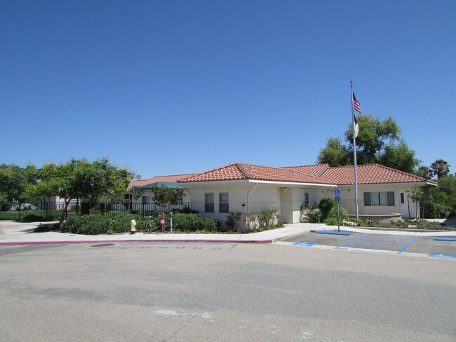
Property Detail
5570 Old Ranch Rd
157-412-18
PAR 2 (EX ST) TR PM08946
Religious
SAN DIEGO
RM-A-SP-EQ
California
B and X Area of moderate flood hazard, usually the area between the limits of the 100-year and 500-year floods.
4.68 AC
2024
Oceanside
2025
San Diego
019303
San Diego-Chula Vista-Carlsbad, CA
9,595 SF
NEARBY LISTINGS FOR SALE OR LEASE
DEMOGRAPHICS near 5570 Old Ranch Rd
1 mile
3 mile
5 mile
2025 Total Population
7,129
98,090
214,010
2030 Population
7,085
98,053
214,868
Pop Growth 2025-2030
(0.62%)
(0.04%)
+ 0.40%
Average Age
42
39
39
2025 Total Households
2,306
30,320
69,327
HH Growth 2025-2030
(0.82%)
(0.21%)
+ 0.31%
Median Household Inc
$156,158
$108,821
$100,640
Avg Household Size
3.00
3.10
2.90
2025 Avg HH Vehicles
3.00
2.00
2.00
Median Home Value
$792,048
$738,254
$735,274
Median Year Built
1985
1985
1983
Nearby Places
Map Layers
Map Styles
 Street
 Aerial
Layers
 Traffic
 Biking
Places
Listings with unknown addresses are not visible on the map
- Restaurants
- Banks
- Shops
- Fitness
- Groceries
PUBLIC TRANSPORTATION
COMMUTER RAIL
Oceanside Transit Center (Orange County Line - Southern California Regional Rail Authority (Metrolink))
Drive
Walk
Distance
Oceanside Transit Center (Orange County Line - Southern California Regional Rail Authority (Metrolink))
16 min
9.5 mi
Freight Ports
Port of San Diego
Drive
Walk
Distance
Port of San Diego
63 min
48.0 mi
SALE & LEASE HISTORY
LISTING DATE
SALE/LEASE

Mar 29, 2017
For Lease
Nearby Properties
Address
Land Use
TOTAL SIZE
Lot Size
Zoning
Address
Land Use
TOTAL SIZE
Lot Size
Zoning
20.10 AC
M-U
Address
Land Use
TOTAL SIZE
Lot Size
Zoning
10.39 AC
M-U (40)
Address
Land Use
TOTAL SIZE
Lot Size
Zoning
18.89 AC
PD-1 (Res)
Address
Land Use
TOTAL SIZE
Lot Size
Zoning
11.17 AC
M-U
Address
Land Use
TOTAL SIZE
Lot Size
Zoning
31.94 AC
RM-B
Address
Land Use
TOTAL SIZE
Lot Size
Zoning
38.61 AC
PD-1 (IL)
Address
Land Use
TOTAL SIZE
Lot Size
Zoning
21.44 AC
C-1
Address
Land Use
TOTAL SIZE
Lot Size
Zoning
6.87 AC
CN-SP-EQ
Address
Land Use
TOTAL SIZE
Lot Size
Zoning
14.08 AC
RH
Address
Land Use
TOTAL SIZE
Lot Size
Zoning
6.55 AC
R-M
Address
Land Use
TOTAL SIZE
Lot Size
Zoning
11.60 AC
RM-C
Address
Land Use
TOTAL SIZE
Lot Size
Zoning
3.32 AC
SPI
Address
Land Use
TOTAL SIZE
Lot Size
Zoning
10.59 AC
RH
Address
Land Use
TOTAL SIZE
Lot Size
Zoning
4.34 AC
SP-08
Address
Land Use
TOTAL SIZE
Lot Size
Zoning
7.18 AC
R-M
Address
Land Use
TOTAL SIZE
Lot Size
Zoning
99,906 SF
5.06 AC
R-M
Address
Land Use
TOTAL SIZE
Lot Size
Zoning
15.61 AC
PD-1 (C)
Address
Land Use
TOTAL SIZE
Lot Size
Zoning
57,489 SF
6.49 AC
PD-1 (IL)
Address
Land Use
TOTAL SIZE
Lot Size
Zoning
10.05 AC
RM-B
Address
Land Use
TOTAL SIZE
Lot Size
Zoning
6.53 AC
R-M
Address
Land Use
TOTAL SIZE
Lot Size
Zoning
89,926 SF
4.25 AC
C-1
Address
Land Use
TOTAL SIZE
Lot Size
Zoning
56,500 SF
5.02 AC
R-1
Address
Land Use
TOTAL SIZE
Lot Size
Zoning
7.51 AC
PD-1 (IL)
Address
Land Use
TOTAL SIZE
Lot Size
Zoning
97,066 SF
10 AC
IL
Address
Land Use
TOTAL SIZE
Lot Size
Zoning
4.84 AC
CL
Address
Land Use
TOTAL SIZE
Lot Size
Zoning
4.03 AC
70
Address
Land Use
TOTAL SIZE
Lot Size
Zoning
7.82 AC
IL-MP-3-82
Address
Land Use
TOTAL SIZE
Lot Size
Zoning
88,361 SF
4.94 AC
IL
Address
Land Use
TOTAL SIZE
Lot Size
Zoning
57,714 SF
5.61 AC
PD-1 (C)
Address
Land Use
TOTAL SIZE
Lot Size
Zoning
6.67 AC
PD-1 (IL)
The World's #1 Commercial Real Estate Marketplace
Connect with us
© 2026 CoStar Group
The information above has been obtained from sources believed reliable. While we do not doubt its accuracy we have not verified it and make no guarantee, warranty or representation about it. It is your responsibility to independently confirm its accuracy and completeness. Any projections, opinions, assumptions, or estimates used are for example only and do not represent the current or future performance of the property. The value of this transaction to you depends on tax and other factors which should be evaluated by your tax, financial, and legal advisors. You and your advisors should conduct a careful, independent investigation of the property to determine to your satisfaction the suitability of the property for your needs.