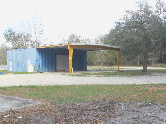
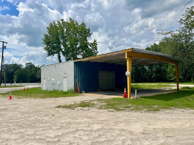
Property Record
558 N Highway 17, Palatka, FL 32177

NEARBY LISTINGS FOR SALE OR LEASE
Property Detail
558 N Highway 17
Palatka, FL
Prices
23-09-26-0000-0210-0000
PT OF SEC 23 + PT OF SEC 24, LYING WEST OF ACL RR BK126, P319 BK135 P87 (EX BK132 P71, BK172 P25 BK185 P593 OR32 P258, RD OR312 P413) (PRICES S/D)
Warehouse
Putnam
A
Florida
12107C0185C
1
2025
17.20 AC
2025
Florida Central North Area
950100
Other Market Areas
972 SF
DEMOGRAPHICS near 558 N Highway 17
1 Mile
3 Mile
5 Mile
2024 Total Population
69
1,496
14,900
2029 Population
72
1,559
15,379
Pop Growth 2024-2029
+ 4.35%
+ 4.21%
+ 3.21%
Average Age
39
44
41
2024 Total Households
26
594
5,860
HH Growth 2024-2029
+ 3.85%
+ 4.04%
+ 3.07%
Median Household Inc
$46,250
$50,833
$29,551
Avg Household Size
2.80
2.50
2.40
2024 Avg HH Vehicles
2.00
2.00
2.00
Median Home Value
$142,857
$194,244
$135,320
Median Year Built
1991
1984
1973
Nearby Places
Map Layers
Map Styles
 Street
 Aerial
- Restaurants
- Banks
- Shops
- Fitness
- Groceries
PUBLIC TRANSPORTATION
COMMUTER RAIL
Palatka Amtrak (Silver Meteor - Amtrak, Silver Star - Amtrak)
DRIVE
WALK
Distance
Palatka Amtrak (Silver Meteor - Amtrak, Silver Star - Amtrak)
8 min
4.8 mi
Freight Ports
Jacksonville Port
DRIVE
WALK
Distance
Jacksonville Port
79 min
52.4 mi
SALE & LEASE HISTORY
LISTING DATE
SALE/LEASE

May 29, 2024
For Lease
Feb 14, 2020
For Sale
Dec 02, 2022
For Lease
Nearby Properties
Address
Land Use
TOTAL SIZE
Lot Size
Zoning
Address
Land Use
TOTAL SIZE
Lot Size
Zoning
22,360 SF
103.82 AC
Address
Land Use
TOTAL SIZE
Lot Size
Zoning
211,250 SF
586.70 AC
Address
Land Use
TOTAL SIZE
Lot Size
Zoning
21,608 SF
1,990.73 AC
Address
Land Use
TOTAL SIZE
Lot Size
Zoning
54,720 SF
29.19 AC
Address
Land Use
TOTAL SIZE
Lot Size
Zoning
33,616 SF
38.79 AC
Address
Land Use
TOTAL SIZE
Lot Size
Zoning
1,107 SF
21.57 AC
Address
Land Use
TOTAL SIZE
Lot Size
Zoning
75,592 SF
7.87 AC
Address
Land Use
TOTAL SIZE
Lot Size
Zoning
2,450 SF
26.46 AC
Address
Land Use
TOTAL SIZE
Lot Size
Zoning
684 SF
184.90 AC
Address
Land Use
TOTAL SIZE
Lot Size
Zoning
2,816 SF
15.84 AC
Address
Land Use
TOTAL SIZE
Lot Size
Zoning
176,814 SF
4.64 AC
Address
Land Use
TOTAL SIZE
Lot Size
Zoning
12,960 SF
4.52 AC
Address
Land Use
TOTAL SIZE
Lot Size
Zoning
2,980 SF
38.86 AC
Address
Land Use
TOTAL SIZE
Lot Size
Zoning
10,560 SF
4.65 AC
Address
Land Use
TOTAL SIZE
Lot Size
Zoning
2,850 SF
0.60 AC
Address
Land Use
TOTAL SIZE
Lot Size
Zoning
19,610 SF
18.28 AC
Address
Land Use
TOTAL SIZE
Lot Size
Zoning
5.03 AC
Address
Land Use
TOTAL SIZE
Lot Size
Zoning
7,544 SF
24.09 AC
Address
Land Use
TOTAL SIZE
Lot Size
Zoning
18,861 SF
5.68 AC
Address
Land Use
TOTAL SIZE
Lot Size
Zoning
2,346 SF
287.33 AC
Address
Land Use
TOTAL SIZE
Lot Size
Zoning
3,614 SF
61.87 AC
Address
Land Use
TOTAL SIZE
Lot Size
Zoning
2,048 SF
7.77 AC
Address
Land Use
TOTAL SIZE
Lot Size
Zoning
2,108 SF
5.42 AC
Address
Land Use
TOTAL SIZE
Lot Size
Zoning
768 SF
7.16 AC
Address
Land Use
TOTAL SIZE
Lot Size
Zoning
118.46 AC
Address
Land Use
TOTAL SIZE
Lot Size
Zoning
24,920 SF
14.82 AC
Address
Land Use
TOTAL SIZE
Lot Size
Zoning
3,924 SF
2.97 AC
Address
Land Use
TOTAL SIZE
Lot Size
Zoning
27,424 SF
4.57 AC
Address
Land Use
TOTAL SIZE
Lot Size
Zoning
2,412 SF
3.34 AC
Address
Land Use
TOTAL SIZE
Lot Size
Zoning
23,584 SF
6.21 AC
The World's #1 Commercial Real Estate Marketplace
Connect with us
© 2026 CoStar Group
The information above has been obtained from sources believed reliable. While we do not doubt its accuracy we have not verified it and make no guarantee, warranty or representation about it. It is your responsibility to independently confirm its accuracy and completeness. Any projections, opinions, assumptions, or estimates used are for example only and do not represent the current or future performance of the property. The value of this transaction to you depends on tax and other factors which should be evaluated by your tax, financial, and legal advisors. You and your advisors should conduct a careful, independent investigation of the property to determine to your satisfaction the suitability of the property for your needs.