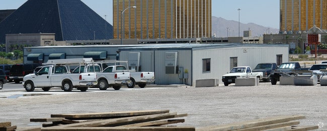
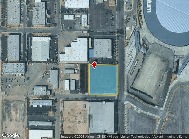
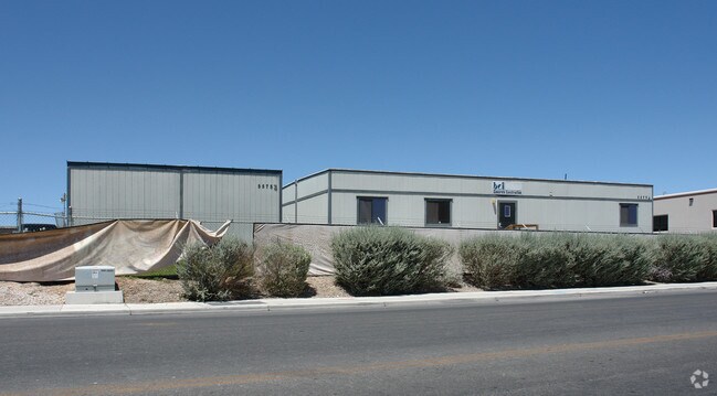
Property Record
5585 Polaris Ave, Las Vegas, NV 89118

NEARBY LISTINGS FOR SALE OR LEASE
Property Detail
5585 Polaris Ave
162-29-401-011
PT SW4 SW4 SEC 29 21 61
Commercialnec
Clark
X
Nevada
32003C2560F
2.12 AC
2025
Southwest Las Vegas
2025
Las Vegas
002962
Las Vegas-Henderson-Paradise, NV
DEMOGRAPHICS near 5585 Polaris Ave
1 Mile
3 Mile
5 Mile
2024 Total Population
411
88,988
375,543
2029 Population
464
96,135
405,170
Pop Growth 2024-2029
+ 12.90%
+ 8.03%
+ 7.89%
Average Age
40
40
40
2024 Total Households
161
40,279
155,946
HH Growth 2024-2029
+ 12.42%
+ 8.12%
+ 7.89%
Median Household Inc
$56,227
$45,248
$52,291
Avg Household Size
2.50
2.10
2.30
2024 Avg HH Vehicles
2.00
1.00
2.00
Median Home Value
$236,904
$316,832
$360,607
Median Year Built
1992
1989
1990
Nearby Places
Map Layers
Map Styles
 Street
 Aerial
- Restaurants
- Banks
- Shops
- Fitness
- Groceries
PUBLIC TRANSPORTATION
AIRPORT
Harry Reid International
DRIVE
WALK
Distance
Harry Reid International
10 min
4.2 mi
Boulder City Municipal
DRIVE
WALK
Distance
Boulder City Municipal
35 min
25.7 mi
Freight Ports
Port of Long Beach
DRIVE
WALK
Distance
Port of Long Beach
309 min
277.5 mi
Nearby Properties
Address
Land Use
TOTAL SIZE
Lot Size
Zoning
Address
Land Use
TOTAL SIZE
Lot Size
Zoning
2,000,377 SF
118.89 AC
Address
Land Use
TOTAL SIZE
Lot Size
Zoning
3,693,440 SF
43.59 AC
Address
Land Use
TOTAL SIZE
Lot Size
Zoning
3,391,505 SF
68.55 AC
Address
Land Use
TOTAL SIZE
Lot Size
Zoning
1,546,466 SF
61.43 AC
H1
Address
Land Use
TOTAL SIZE
Lot Size
Zoning
2,207,746 SF
74.17 AC
Address
Land Use
TOTAL SIZE
Lot Size
Zoning
2,828,726 SF
101.88 AC
Address
Land Use
TOTAL SIZE
Lot Size
Zoning
937,376 SF
59.19 AC
Address
Land Use
TOTAL SIZE
Lot Size
Zoning
820,224 SF
59.80 AC
H1
Address
Land Use
TOTAL SIZE
Lot Size
Zoning
1,494,289 SF
65.25 AC
H1
Address
Land Use
TOTAL SIZE
Lot Size
Zoning
2,414,853 SF
16.59 AC
H1
Address
Land Use
TOTAL SIZE
Lot Size
Zoning
1,166,098 SF
57.58 AC
Address
Land Use
TOTAL SIZE
Lot Size
Zoning
74,148 SF
18.51 AC
Address
Land Use
TOTAL SIZE
Lot Size
Zoning
763,204 SF
10.47 AC
H1
Address
Land Use
TOTAL SIZE
Lot Size
Zoning
225,512 SF
50.14 AC
Address
Land Use
TOTAL SIZE
Lot Size
Zoning
114,591 SF
20.60 AC
Address
Land Use
TOTAL SIZE
Lot Size
Zoning
742,547 SF
19.87 AC
H1
Address
Land Use
TOTAL SIZE
Lot Size
Zoning
248,689 SF
19.45 AC
H1
Address
Land Use
TOTAL SIZE
Lot Size
Zoning
171,303 SF
17.87 AC
H1
Address
Land Use
TOTAL SIZE
Lot Size
Zoning
318,259 SF
29.92 AC
Address
Land Use
TOTAL SIZE
Lot Size
Zoning
1,911,901 SF
1.24 AC
Address
Land Use
TOTAL SIZE
Lot Size
Zoning
299,144 SF
19.37 AC
Address
Land Use
TOTAL SIZE
Lot Size
Zoning
79.03 AC
PF
Address
Land Use
TOTAL SIZE
Lot Size
Zoning
777,838 SF
36.14 AC
H1
Address
Land Use
TOTAL SIZE
Lot Size
Zoning
3,200 SF
16.74 AC
Address
Land Use
TOTAL SIZE
Lot Size
Zoning
1,744,547 SF
8.25 AC
Address
Land Use
TOTAL SIZE
Lot Size
Zoning
754,711 SF
24.79 AC
H1
Address
Land Use
TOTAL SIZE
Lot Size
Zoning
873,377 SF
28.08 AC
Address
Land Use
TOTAL SIZE
Lot Size
Zoning
1,345,377 SF
88.53 AC
H1
Address
Land Use
TOTAL SIZE
Lot Size
Zoning
764,918 SF
94.41 AC
H1
Address
Land Use
TOTAL SIZE
Lot Size
Zoning
323,696 SF
24.62 AC
H1
The World's #1 Commercial Real Estate Marketplace
Connect with us
© 2025 CoStar Group
The information above has been obtained from sources believed reliable. While we do not doubt its accuracy we have not verified it and make no guarantee, warranty or representation about it. It is your responsibility to independently confirm its accuracy and completeness. Any projections, opinions, assumptions, or estimates used are for example only and do not represent the current or future performance of the property. The value of this transaction to you depends on tax and other factors which should be evaluated by your tax, financial, and legal advisors. You and your advisors should conduct a careful, independent investigation of the property to determine to your satisfaction the suitability of the property for your needs.