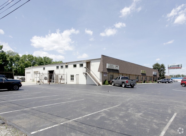
Property Record
5585 Westerville Rd, Westerville, OH 43081

NEARBY LISTINGS FOR SALE OR LEASE
Property Detail
5585 Westerville Rd
Columbus, OH
United States Military Lands
110-000879
5565 WESTERVILLE RD R17 T2 1/4T3 LOT 3 3.453 ACRES
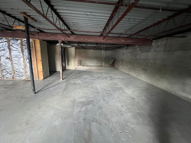
Storebuilding
Franklin
X
Ohio
39049C0183K
3 3
2024
3.08 AC
2024
Westerville
007120
Columbus
34,760 SF
DEMOGRAPHICS near 5585 Westerville Rd
1 Mile
3 Mile
5 Mile
2024 Total Population
17,027
116,284
284,451
2029 Population
16,943
115,869
286,219
Pop Growth 2024-2029
(0.49%)
(0.36%)
+ 0.62%
Average Age
36
37
38
2024 Total Households
6,690
45,058
115,778
HH Growth 2024-2029
(0.37%)
(0.35%)
+ 0.65%
Median Household Inc
$64,869
$61,625
$69,128
Avg Household Size
2.50
2.50
2.40
2024 Avg HH Vehicles
2.00
2.00
2.00
Median Home Value
$193,936
$220,259
$244,609
Median Year Built
1976
1976
1980
Nearby Places
Map Layers
Map Styles
 Street
 Aerial
- Restaurants
- Banks
- Shops
- Fitness
- Groceries
PUBLIC TRANSPORTATION
AIRPORT
John Glenn Columbus International
DRIVE
WALK
Distance
John Glenn Columbus International
16 min
9.3 mi
Rickenbacker International
DRIVE
WALK
Distance
Rickenbacker International
34 min
25.5 mi
Freight Ports
Port of Toledo
DRIVE
WALK
Distance
Port of Toledo
176 min
139.2 mi
SALE & LEASE HISTORY
LISTING DATE
SALE/LEASE

Mar 31, 2025
For Lease
Nearby Properties
Address
Land Use
TOTAL SIZE
Lot Size
Zoning
Address
Land Use
TOTAL SIZE
Lot Size
Zoning
2,299,970 SF
60.76 AC
Address
Land Use
TOTAL SIZE
Lot Size
Zoning
440,828 SF
13.72 AC
Address
Land Use
TOTAL SIZE
Lot Size
Zoning
1,935,173 SF
202.04 AC
Address
Land Use
TOTAL SIZE
Lot Size
Zoning
529,035 SF
37.56 AC
Address
Land Use
TOTAL SIZE
Lot Size
Zoning
449,494 SF
9.75 AC
Address
Land Use
TOTAL SIZE
Lot Size
Zoning
426,490 SF
19.43 AC
Address
Land Use
TOTAL SIZE
Lot Size
Zoning
316,548 SF
145.20 AC
Address
Land Use
TOTAL SIZE
Lot Size
Zoning
516,485 SF
50.03 AC
Address
Land Use
TOTAL SIZE
Lot Size
Zoning
697,077 SF
40.91 AC
Address
Land Use
TOTAL SIZE
Lot Size
Zoning
159,315 SF
13.25 AC
Address
Land Use
TOTAL SIZE
Lot Size
Zoning
668,209 SF
61.10 AC
Address
Land Use
TOTAL SIZE
Lot Size
Zoning
165,944 SF
14.21 AC
Address
Land Use
TOTAL SIZE
Lot Size
Zoning
3,263 SF
989.66 AC
Address
Land Use
TOTAL SIZE
Lot Size
Zoning
331,458 SF
15.37 AC
Address
Land Use
TOTAL SIZE
Lot Size
Zoning
152,684 SF
20.94 AC
Address
Land Use
TOTAL SIZE
Lot Size
Zoning
201,072 SF
22.28 AC
Address
Land Use
TOTAL SIZE
Lot Size
Zoning
292,377 SF
36.29 AC
Address
Land Use
TOTAL SIZE
Lot Size
Zoning
150,718 SF
4.35 AC
Address
Land Use
TOTAL SIZE
Lot Size
Zoning
500,376 SF
3 AC
Address
Land Use
TOTAL SIZE
Lot Size
Zoning
194,750 SF
13.53 AC
Address
Land Use
TOTAL SIZE
Lot Size
Zoning
236,681 SF
7.83 AC
Address
Land Use
TOTAL SIZE
Lot Size
Zoning
135,898 SF
0.78 AC
Address
Land Use
TOTAL SIZE
Lot Size
Zoning
112,288 SF
1.12 AC
Address
Land Use
TOTAL SIZE
Lot Size
Zoning
142,998 SF
30.25 AC
Address
Land Use
TOTAL SIZE
Lot Size
Zoning
198,207 SF
4.74 AC
Address
Land Use
TOTAL SIZE
Lot Size
Zoning
358,807 SF
1.77 AC
Address
Land Use
TOTAL SIZE
Lot Size
Zoning
89,544 SF
4.82 AC
Address
Land Use
TOTAL SIZE
Lot Size
Zoning
85,854 SF
1.13 AC
Address
Land Use
TOTAL SIZE
Lot Size
Zoning
353,528 SF
1.28 AC
Address
Land Use
TOTAL SIZE
Lot Size
Zoning
172,848 SF
5.34 AC
The World's #1 Commercial Real Estate Marketplace
Connect with us
© 2025 CoStar Group
The information above has been obtained from sources believed reliable. While we do not doubt its accuracy we have not verified it and make no guarantee, warranty or representation about it. It is your responsibility to independently confirm its accuracy and completeness. Any projections, opinions, assumptions, or estimates used are for example only and do not represent the current or future performance of the property. The value of this transaction to you depends on tax and other factors which should be evaluated by your tax, financial, and legal advisors. You and your advisors should conduct a careful, independent investigation of the property to determine to your satisfaction the suitability of the property for your needs.