Property Record
5588 Lascassas Pike, Lascassas, TN 37085


Property Detail
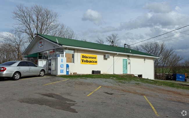
5588 Lascassas Pike
060-032.00-000
200M X 65M IRR
Conveniencestore
Rutherford
AE The base floodplain where base flood elevations are provided. AE Zones are now used on new format FIRMs instead of A1-A30 Zones.
Tennessee
2025
0.55 AC
2025
Rutherford County
040502
Nashville
2,520 SF
Nashville-Davidson--Murfreesboro--Franklin, TN
NEARBY LISTINGS FOR SALE OR LEASE
-
-
View all Lascassas listings for sale on LoopNet.com
DEMOGRAPHICS near 5588 Lascassas Pike
1 mile
3 mile
5 mile
2024 Total Population
1,563
5,958
19,984
2029 Population
1,707
6,503
21,666
Pop Growth 2024-2029
+ 9.21%
+ 9.15%
+ 8.42%
Average Age
39
40
40
2024 Total Households
536
2,063
7,052
HH Growth 2024-2029
+ 9.33%
+ 9.26%
+ 8.56%
Median Household Inc
$121,794
$113,817
$104,663
Avg Household Size
2.90
2.90
2.80
2024 Avg HH Vehicles
2.00
2.00
2.00
Median Home Value
$491,249
$484,615
$453,317
Median Year Built
2002
2000
1998
Nearby Places
Map Layers
Map Styles
 Street
 Aerial
Transit
 Traffic
 Biking
Places
Listings with unknown addresses are not visible on the map
- Restaurants
- Banks
- Shops
- Fitness
- Groceries
PUBLIC TRANSPORTATION
AIRPORT
Nashville International
Drive
Walk
Distance
Nashville International
48 min
28.6 mi
Nearby Properties
Address
Land Use
TOTAL SIZE
Lot Size
Zoning
Address
Land Use
TOTAL SIZE
Lot Size
Zoning
102,400 SF
26.65 AC
Address
Land Use
TOTAL SIZE
Lot Size
Zoning
27,415 SF
3.23 AC
Address
Land Use
TOTAL SIZE
Lot Size
Zoning
11,964 SF
0.52 AC
Address
Land Use
TOTAL SIZE
Lot Size
Zoning
45,854 SF
5 AC
Address
Land Use
TOTAL SIZE
Lot Size
Zoning
3,300 SF
5 AC
Address
Land Use
TOTAL SIZE
Lot Size
Zoning
97.73 AC
Address
Land Use
TOTAL SIZE
Lot Size
Zoning
11,533 SF
5.67 AC
Address
Land Use
TOTAL SIZE
Lot Size
Zoning
7,058 SF
1.66 AC
Address
Land Use
TOTAL SIZE
Lot Size
Zoning
5,314 SF
0.70 AC
Address
Land Use
TOTAL SIZE
Lot Size
Zoning
34.50 AC
Address
Land Use
TOTAL SIZE
Lot Size
Zoning
5,144 SF
1.30 AC
Address
Land Use
TOTAL SIZE
Lot Size
Zoning
10,500 SF
7.19 AC
Address
Land Use
TOTAL SIZE
Lot Size
Zoning
23.79 AC
Address
Land Use
TOTAL SIZE
Lot Size
Zoning
5,106 SF
1 AC
Address
Land Use
TOTAL SIZE
Lot Size
Zoning
9.30 AC
Address
Land Use
TOTAL SIZE
Lot Size
Zoning
8.35 AC
Address
Land Use
TOTAL SIZE
Lot Size
Zoning
Address
Land Use
TOTAL SIZE
Lot Size
Zoning
7.07 AC
Address
Land Use
TOTAL SIZE
Lot Size
Zoning
Address
Land Use
TOTAL SIZE
Lot Size
Zoning
17.94 AC
Address
Land Use
TOTAL SIZE
Lot Size
Zoning
Address
Land Use
TOTAL SIZE
Lot Size
Zoning
5.01 AC
Address
Land Use
TOTAL SIZE
Lot Size
Zoning
Address
Land Use
TOTAL SIZE
Lot Size
Zoning
5.01 AC
Address
Land Use
TOTAL SIZE
Lot Size
Zoning
14.50 AC
Address
Land Use
TOTAL SIZE
Lot Size
Zoning
4,360 SF
1.59 AC
Address
Land Use
TOTAL SIZE
Lot Size
Zoning
3,000 SF
0.80 AC
Address
Land Use
TOTAL SIZE
Lot Size
Zoning
2,080 SF
5.70 AC
Address
Land Use
TOTAL SIZE
Lot Size
Zoning
6.53 AC
The World's #1 Commercial Real Estate Marketplace
Connect with us
© 2026 CoStar Group
The information above has been obtained from sources believed reliable. While we do not doubt its accuracy we have not verified it and make no guarantee, warranty or representation about it. It is your responsibility to independently confirm its accuracy and completeness. Any projections, opinions, assumptions, or estimates used are for example only and do not represent the current or future performance of the property. The value of this transaction to you depends on tax and other factors which should be evaluated by your tax, financial, and legal advisors. You and your advisors should conduct a careful, independent investigation of the property to determine to your satisfaction the suitability of the property for your needs.