Property Record
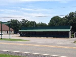
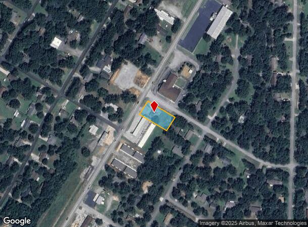
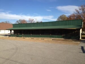
559 Heber Springs Rd, Southside, AR 72501
NEARBY LISTINGS FOR SALE OR LEASE
Property Detail
559 Heber Springs Rd
1200485001C
Clearview Fourth Sub
Roadsidemarket
PT SE PT PARCEL C
X
Independence
05063C0350D
Arkansas
2025
0.46 AC
2025
Arkansas North Area
490701
Other Market Areas
2,580 SF
Batesville, AR
DEMOGRAPHICS near 559 Heber Springs Rd
1 Mile
3 Mile
5 Mile
2024 Total Population
1,311
10,347
19,637
2029 Population
1,302
10,428
19,775
Pop Growth 2024-2029
(0.69%)
+ 0.78%
+ 0.70%
Average Age
40
39
39
2024 Total Households
527
4,192
7,758
HH Growth 2024-2029
(0.76%)
+ 0.81%
+ 0.72%
Median Household Inc
$64,086
$46,460
$49,752
Avg Household Size
2.40
2.40
2.40
2024 Avg HH Vehicles
2.00
2.00
2.00
Median Home Value
$145,967
$126,701
$119,852
Median Year Built
1981
1983
1984
Nearby Places
Map Layers
Map Styles
 Street
 Aerial
- Restaurants
- Banks
- Shops
- Fitness
- Groceries
Nearby Properties
Address
Land Use
TOTAL SIZE
Lot Size
Zoning
Address
Land Use
TOTAL SIZE
Lot Size
Zoning
97,126 SF
22.91 AC
Address
Land Use
TOTAL SIZE
Lot Size
Zoning
45,884 SF
2.41 AC
Address
Land Use
TOTAL SIZE
Lot Size
Zoning
187,670 SF
5.07 AC
Address
Land Use
TOTAL SIZE
Lot Size
Zoning
31,028 SF
2.42 AC
Address
Land Use
TOTAL SIZE
Lot Size
Zoning
260,612 SF
15.25 AC
Address
Land Use
TOTAL SIZE
Lot Size
Zoning
26,400 SF
1.22 AC
Address
Land Use
TOTAL SIZE
Lot Size
Zoning
119,460 SF
4.51 AC
Address
Land Use
TOTAL SIZE
Lot Size
Zoning
59,530 SF
14.15 AC
Address
Land Use
TOTAL SIZE
Lot Size
Zoning
49,512 SF
2.24 AC
Address
Land Use
TOTAL SIZE
Lot Size
Zoning
37,478 SF
10.72 AC
Address
Land Use
TOTAL SIZE
Lot Size
Zoning
21,789 SF
14.89 AC
Address
Land Use
TOTAL SIZE
Lot Size
Zoning
18,254 SF
2.81 AC
Address
Land Use
TOTAL SIZE
Lot Size
Zoning
79,146 SF
4.97 AC
Address
Land Use
TOTAL SIZE
Lot Size
Zoning
36,008 SF
7 AC
Address
Land Use
TOTAL SIZE
Lot Size
Zoning
64,436 SF
1.93 AC
Address
Land Use
TOTAL SIZE
Lot Size
Zoning
13,658 SF
4.68 AC
Address
Land Use
TOTAL SIZE
Lot Size
Zoning
32,732 SF
1.52 AC
Address
Land Use
TOTAL SIZE
Lot Size
Zoning
2,636 SF
3.96 AC
Address
Land Use
TOTAL SIZE
Lot Size
Zoning
14,736 SF
1.47 AC
Address
Land Use
TOTAL SIZE
Lot Size
Zoning
53,196 SF
11.79 AC
Address
Land Use
TOTAL SIZE
Lot Size
Zoning
27,730 SF
2.16 AC
Address
Land Use
TOTAL SIZE
Lot Size
Zoning
32,204 SF
2.76 AC
Address
Land Use
TOTAL SIZE
Lot Size
Zoning
9,372 SF
1.78 AC
Address
Land Use
TOTAL SIZE
Lot Size
Zoning
22,500 SF
3.94 AC
Address
Land Use
TOTAL SIZE
Lot Size
Zoning
10,830 SF
1.90 AC
Address
Land Use
TOTAL SIZE
Lot Size
Zoning
17,534 SF
2.39 AC
Address
Land Use
TOTAL SIZE
Lot Size
Zoning
15,609 SF
1.55 AC
Address
Land Use
TOTAL SIZE
Lot Size
Zoning
35,676 SF
3.58 AC
Address
Land Use
TOTAL SIZE
Lot Size
Zoning
28,696 SF
3.09 AC
Address
Land Use
TOTAL SIZE
Lot Size
Zoning
61,402 SF
3.80 AC
The World's #1 Commercial Real Estate Marketplace
Connect with us
© 2025 CoStar Group
The information above has been obtained from sources believed reliable. While we do not doubt its accuracy we have not verified it and make no guarantee, warranty or representation about it. It is your responsibility to independently confirm its accuracy and completeness. Any projections, opinions, assumptions, or estimates used are for example only and do not represent the current or future performance of the property. The value of this transaction to you depends on tax and other factors which should be evaluated by your tax, financial, and legal advisors. You and your advisors should conduct a careful, independent investigation of the property to determine to your satisfaction the suitability of the property for your needs.