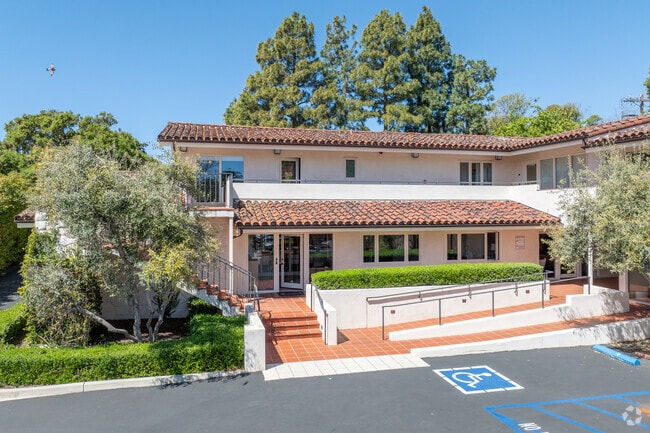
Property Record
559 San Ysidro Rd, Santa Barbara, CA 93108


NEARBY LISTINGS FOR SALE OR LEASE
Property Detail
559 San Ysidro Rd
Santa Maria-Santa Barbara, CA
A11 200
011-200-065
PUEBLO MAP 30A LOTS 74 LOT 75
Officebuilding
Santa Barbara
X
California
06083C1384G
75
2024
0.78 AC
2025
S Santa Barbara Coastal
001500
Santa Barbara/Sta Maria/Goleta
9,717 SF
DEMOGRAPHICS near 559 San Ysidro Rd
1 Mile
3 Mile
5 Mile
2024 Total Population
3,226
23,983
64,709
2029 Population
3,274
24,061
64,403
Pop Growth 2024-2029
+ 1.49%
+ 0.33%
(0.47%)
Average Age
51
43
41
2024 Total Households
1,393
8,760
25,879
HH Growth 2024-2029
+ 1.36%
+ 0.46%
(0.56%)
Median Household Inc
$178,145
$137,890
$98,238
Avg Household Size
2.30
2.50
2.30
2024 Avg HH Vehicles
2.00
2.00
2.00
Median Home Value
$1,144,066
$1,120,786
$1,105,641
Median Year Built
1972
1967
1964
Nearby Places
Map Layers
Map Styles
 Street
 Aerial
- Restaurants
- Banks
- Shops
- Fitness
- Groceries
PUBLIC TRANSPORTATION
COMMUTER RAIL
Santa Barbara (Coast Starlight - Amtrak, Pacific Surfliner - Amtrak)
DRIVE
WALK
Distance
Santa Barbara (Coast Starlight - Amtrak, Pacific Surfliner - Amtrak)
9 min
4.7 mi
Carpinteria Amtrak (Pacific Surfliner - Amtrak)
DRIVE
WALK
Distance
Carpinteria Amtrak (Pacific Surfliner - Amtrak)
13 min
8.2 mi
AIRPORT
Santa Barbara Municipal
DRIVE
WALK
Distance
Santa Barbara Municipal
35 min
16.9 mi
Freight Ports
The Port of Hueneme
DRIVE
WALK
Distance
The Port of Hueneme
51 min
36.8 mi
SALE & LEASE HISTORY
LISTING DATE
SALE/LEASE

Sep 30, 2019
For Sale
Sep 25, 2016
For Lease
Jun 14, 2018
For Lease
Feb 20, 2020
For Lease
Apr 27, 2018
For Sale
Nearby Properties
Address
Land Use
TOTAL SIZE
Lot Size
Zoning
Address
Land Use
TOTAL SIZE
Lot Size
Zoning
12.32 AC
CV
Address
Land Use
TOTAL SIZE
Lot Size
Zoning
Address
Land Use
TOTAL SIZE
Lot Size
Zoning
21.85 AC
HRC1SP
Address
Land Use
TOTAL SIZE
Lot Size
Zoning
51,425 SF
28.35 AC
MRP
Address
Land Use
TOTAL SIZE
Lot Size
Zoning
Address
Land Use
TOTAL SIZE
Lot Size
Zoning
Address
Land Use
TOTAL SIZE
Lot Size
Zoning
77.82 AC
A2SD3
Address
Land Use
TOTAL SIZE
Lot Size
Zoning
183,552 SF
50.14 AC
SP5
Address
Land Use
TOTAL SIZE
Lot Size
Zoning
1.12 AC
HRC1SD
Address
Land Use
TOTAL SIZE
Lot Size
Zoning
16,816 SF
1.02 AC
CV
Address
Land Use
TOTAL SIZE
Lot Size
Zoning
1 AC
HRC1SD
Address
Land Use
TOTAL SIZE
Lot Size
Zoning
1.29 AC
HRC1SD
Address
Land Use
TOTAL SIZE
Lot Size
Zoning
4,415 SF
6.56 AC
CV
Address
Land Use
TOTAL SIZE
Lot Size
Zoning
3.17 AC
R2
Address
Land Use
TOTAL SIZE
Lot Size
Zoning
12,387 SF
3.26 AC
CV
Address
Land Use
TOTAL SIZE
Lot Size
Zoning
5,929 SF
6.70 AC
5E1
Address
Land Use
TOTAL SIZE
Lot Size
Zoning
1.95 AC
HRC2SD
Address
Land Use
TOTAL SIZE
Lot Size
Zoning
888 SF
0.60 AC
Address
Land Use
TOTAL SIZE
Lot Size
Zoning
630 SF
1.32 AC
CN
Address
Land Use
TOTAL SIZE
Lot Size
Zoning
1,280 SF
76.87 AC
2E1
Address
Land Use
TOTAL SIZE
Lot Size
Zoning
7,112 SF
3.92 AC
2E1
Address
Land Use
TOTAL SIZE
Lot Size
Zoning
0.74 AC
C1SD3
Address
Land Use
TOTAL SIZE
Lot Size
Zoning
24,223 SF
6.31 AC
1E1
Address
Land Use
TOTAL SIZE
Lot Size
Zoning
1.30 AC
C1SD3
Address
Land Use
TOTAL SIZE
Lot Size
Zoning
9.93 AC
2E1
Address
Land Use
TOTAL SIZE
Lot Size
Zoning
4.02 AC
3E1
Address
Land Use
TOTAL SIZE
Lot Size
Zoning
124,667 SF
32.92 AC
10E1
Address
Land Use
TOTAL SIZE
Lot Size
Zoning
2.50 AC
CP
Address
Land Use
TOTAL SIZE
Lot Size
Zoning
0.79 AC
R4SD3
Address
Land Use
TOTAL SIZE
Lot Size
Zoning
0.65 AC
C1SD3
The World's #1 Commercial Real Estate Marketplace
Connect with us
© 2025 CoStar Group
The information above has been obtained from sources believed reliable. While we do not doubt its accuracy we have not verified it and make no guarantee, warranty or representation about it. It is your responsibility to independently confirm its accuracy and completeness. Any projections, opinions, assumptions, or estimates used are for example only and do not represent the current or future performance of the property. The value of this transaction to you depends on tax and other factors which should be evaluated by your tax, financial, and legal advisors. You and your advisors should conduct a careful, independent investigation of the property to determine to your satisfaction the suitability of the property for your needs.