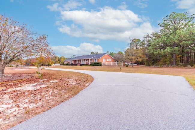
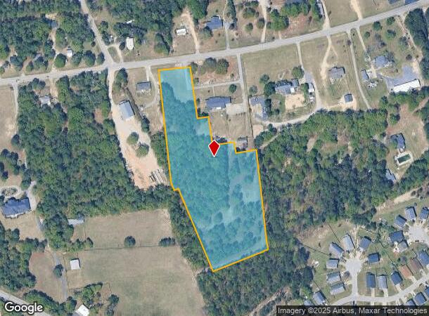
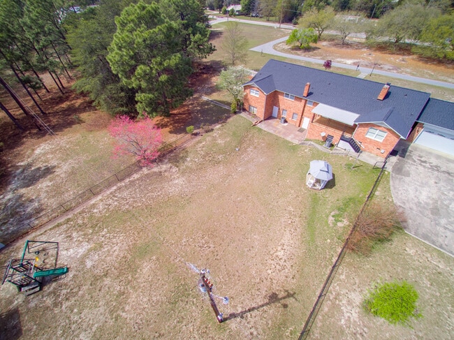
Property Record
559 Two Notch Rd, Lexington, SC 29073
NEARBY LISTINGS FOR SALE OR LEASE
Property Detail
559 Two Notch Rd
Columbia, SC
Prepared For Albert J Dooley Sr
005596-03-019
Lexington
Ruralagriculturalresidence
South Carolina
X
5.83 AC
45063C0254J
Cayce/West Columbia
3,840 SF
Columbia
DEMOGRAPHICS near 559 Two Notch Rd
1 Mile
3 Mile
5 Mile
2024 Total Population
3,675
37,736
85,517
2029 Population
4,005
41,013
93,163
Pop Growth 2024-2029
+ 8.98%
+ 8.68%
+ 8.94%
Average Age
41
40
40
2024 Total Households
1,471
15,156
33,770
HH Growth 2024-2029
+ 9.11%
+ 8.91%
+ 9.14%
Median Household Inc
$67,382
$69,584
$69,772
Avg Household Size
2.40
2.40
2.50
2024 Avg HH Vehicles
2.00
2.00
2.00
Median Home Value
$148,312
$166,833
$186,765
Median Year Built
1995
1994
1995
Nearby Places
Map Layers
Map Styles
 Street
 Aerial
- Restaurants
- Banks
- Shops
- Fitness
- Groceries
PUBLIC TRANSPORTATION
COMMUTER RAIL
Columbia Amtrak Station (Silver Star - Amtrak)
DRIVE
WALK
Distance
Columbia Amtrak Station (Silver Star - Amtrak)
15 min
9.7 mi
AIRPORT
Columbia Metro
DRIVE
WALK
Distance
Columbia Metro
22 min
6.6 mi
Freight Ports
North Charleston Terminal
DRIVE
WALK
Distance
North Charleston Terminal
123 min
107.5 mi
SALE & LEASE HISTORY
LISTING DATE
SALE/LEASE

Nov 22, 2023
For Sale
Nearby Properties
Address
Land Use
TOTAL SIZE
Lot Size
Zoning
Address
Land Use
TOTAL SIZE
Lot Size
Zoning
78,966 SF
10.34 AC
Address
Land Use
TOTAL SIZE
Lot Size
Zoning
37,794 SF
22.37 AC
ID
Address
Land Use
TOTAL SIZE
Lot Size
Zoning
4,198 SF
23.54 AC
Address
Land Use
TOTAL SIZE
Lot Size
Zoning
3,383 SF
20.65 AC
Address
Land Use
TOTAL SIZE
Lot Size
Zoning
58.81 AC
RD
Address
Land Use
TOTAL SIZE
Lot Size
Zoning
257,688 SF
23.03 AC
ID
Address
Land Use
TOTAL SIZE
Lot Size
Zoning
41,860 SF
6.54 AC
ID
Address
Land Use
TOTAL SIZE
Lot Size
Zoning
79,246 SF
9.04 AC
GC
Address
Land Use
TOTAL SIZE
Lot Size
Zoning
3,079 SF
15.93 AC
HDR
Address
Land Use
TOTAL SIZE
Lot Size
Zoning
2,065 SF
19.73 AC
HDR
Address
Land Use
TOTAL SIZE
Lot Size
Zoning
85,600 SF
22.08 AC
Address
Land Use
TOTAL SIZE
Lot Size
Zoning
136,940 SF
20.36 AC
GC
Address
Land Use
TOTAL SIZE
Lot Size
Zoning
70,740 SF
13 AC
ID
Address
Land Use
TOTAL SIZE
Lot Size
Zoning
59.61 AC
ID
Address
Land Use
TOTAL SIZE
Lot Size
Zoning
127,329 SF
10.91 AC
Address
Land Use
TOTAL SIZE
Lot Size
Zoning
85,508 SF
9.22 AC
GC
Address
Land Use
TOTAL SIZE
Lot Size
Zoning
62,141 SF
7.28 AC
GC
Address
Land Use
TOTAL SIZE
Lot Size
Zoning
8,269 SF
12.99 AC
RD
Address
Land Use
TOTAL SIZE
Lot Size
Zoning
51,657 SF
3.48 AC
ID
Address
Land Use
TOTAL SIZE
Lot Size
Zoning
10.52 AC
ID
Address
Land Use
TOTAL SIZE
Lot Size
Zoning
14,820 SF
2.56 AC
Address
Land Use
TOTAL SIZE
Lot Size
Zoning
55,686 SF
6.42 AC
ID
Address
Land Use
TOTAL SIZE
Lot Size
Zoning
1,572 SF
21.04 AC
GC
Address
Land Use
TOTAL SIZE
Lot Size
Zoning
35,109 SF
11.06 AC
GC
Address
Land Use
TOTAL SIZE
Lot Size
Zoning
60,000 SF
4.77 AC
ID
Address
Land Use
TOTAL SIZE
Lot Size
Zoning
115,000 SF
11.99 AC
ID
Address
Land Use
TOTAL SIZE
Lot Size
Zoning
4,088 SF
1.05 AC
RD
Address
Land Use
TOTAL SIZE
Lot Size
Zoning
25,650 SF
1.69 AC
Address
Land Use
TOTAL SIZE
Lot Size
Zoning
36,185 SF
4.04 AC
Address
Land Use
TOTAL SIZE
Lot Size
Zoning
43,078 SF
4.50 AC
The World's #1 Commercial Real Estate Marketplace
Connect with us
© 2026 CoStar Group
The information above has been obtained from sources believed reliable. While we do not doubt its accuracy we have not verified it and make no guarantee, warranty or representation about it. It is your responsibility to independently confirm its accuracy and completeness. Any projections, opinions, assumptions, or estimates used are for example only and do not represent the current or future performance of the property. The value of this transaction to you depends on tax and other factors which should be evaluated by your tax, financial, and legal advisors. You and your advisors should conduct a careful, independent investigation of the property to determine to your satisfaction the suitability of the property for your needs.