Property Record
559 W Germantown Pike, Norristown, PA 19403
NEARBY LISTINGS FOR SALE OR LEASE
Property Detail
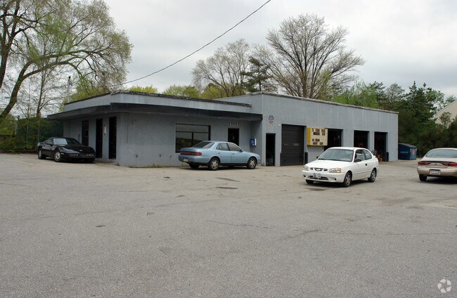
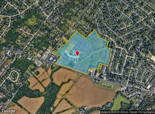
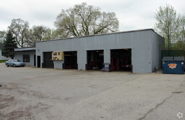
559 W Germantown Pike
Philadelphia-Camden-Wilmington, PA-NJ-DE-MD
Whitehall Construction Co
33-00-03187-002
MKT VALUE 1063160 STD ASSMT 1063160 02 53.40AC
Governmentalpublicusegeneral
Montgomery
X
Pennsylvania
42091C0263G
24
0
80.44 AC
2025
Norristown/Valley Forge
203302
Philadelphia
365,348 SF
DEMOGRAPHICS near 559 W Germantown Pike
1 Mile
3 Mile
5 Mile
2024 Total Population
6,678
83,984
166,203
2029 Population
6,795
85,555
169,082
Pop Growth 2024-2029
+ 1.75%
+ 1.87%
+ 1.73%
Average Age
45
40
41
2024 Total Households
2,838
32,157
64,809
HH Growth 2024-2029
+ 1.87%
+ 1.92%
+ 1.75%
Median Household Inc
$87,803
$80,142
$95,824
Avg Household Size
2.30
2.50
2.40
2024 Avg HH Vehicles
2.00
2.00
2.00
Median Home Value
$310,218
$292,322
$362,525
Median Year Built
1970
1965
1971
Nearby Places
Map Layers
Map Styles
 Street
 Aerial
- Restaurants
- Banks
- Shops
- Fitness
- Groceries
PUBLIC TRANSPORTATION
COMMUTER RAIL
Elm Street (Norristown) (R6 - Southeastern Pennsylvania Transportation Authority Regional Rail (SEPTA Regional Rail))
DRIVE
WALK
Distance
Elm Street (Norristown) (R6 - Southeastern Pennsylvania Transportation Authority Regional Rail (SEPTA Regional Rail))
10 min
3.3 mi
Main Street (Norristown) (R6 - Southeastern Pennsylvania Transportation Authority Regional Rail (SEPTA Regional Rail))
DRIVE
WALK
Distance
Main Street (Norristown) (R6 - Southeastern Pennsylvania Transportation Authority Regional Rail (SEPTA Regional Rail))
10 min
3.6 mi
AIRPORT
Philadelphia International
DRIVE
WALK
Distance
Philadelphia International
50 min
30.6 mi
Trenton Mercer
DRIVE
WALK
Distance
Trenton Mercer
57 min
39.7 mi
Freight Ports
Port of Philadelphia
DRIVE
WALK
Distance
Port of Philadelphia
41 min
22.4 mi
Nearby Properties
Address
Land Use
TOTAL SIZE
Lot Size
Zoning
Address
Land Use
TOTAL SIZE
Lot Size
Zoning
1,807,465 SF
120.12 AC
R2
Address
Land Use
TOTAL SIZE
Lot Size
Zoning
422,975 SF
92.05 AC
RA
Address
Land Use
TOTAL SIZE
Lot Size
Zoning
217,564 SF
12.64 AC
IN
Address
Land Use
TOTAL SIZE
Lot Size
Zoning
231,665 SF
26.34 AC
OSR
Address
Land Use
TOTAL SIZE
Lot Size
Zoning
381,496 SF
5.37 AC
EC
Address
Land Use
TOTAL SIZE
Lot Size
Zoning
311,142 SF
39.51 AC
R1
Address
Land Use
TOTAL SIZE
Lot Size
Zoning
53,368 SF
38.59 AC
R3
Address
Land Use
TOTAL SIZE
Lot Size
Zoning
320,737 SF
0.98 AC
TC
Address
Land Use
TOTAL SIZE
Lot Size
Zoning
416,392 SF
26.56 AC
HR
Address
Land Use
TOTAL SIZE
Lot Size
Zoning
311,784 SF
21.82 AC
A
Address
Land Use
TOTAL SIZE
Lot Size
Zoning
136,637 SF
18 AC
OSR
Address
Land Use
TOTAL SIZE
Lot Size
Zoning
211,739 SF
14.14 AC
CR
Address
Land Use
TOTAL SIZE
Lot Size
Zoning
275,093 SF
10.79 AC
GA
Address
Land Use
TOTAL SIZE
Lot Size
Zoning
133,012 SF
32.23 AC
IN
Address
Land Use
TOTAL SIZE
Lot Size
Zoning
337,873 SF
10.81 AC
HR
Address
Land Use
TOTAL SIZE
Lot Size
Zoning
284,250 SF
17.10 AC
A
Address
Land Use
TOTAL SIZE
Lot Size
Zoning
194,686 SF
10.39 AC
IN
Address
Land Use
TOTAL SIZE
Lot Size
Zoning
102,468 SF
11.48 AC
C
Address
Land Use
TOTAL SIZE
Lot Size
Zoning
109,066 SF
31.76 AC
IN
Address
Land Use
TOTAL SIZE
Lot Size
Zoning
207,661 SF
20 AC
SC
Address
Land Use
TOTAL SIZE
Lot Size
Zoning
160,763 SF
3.84 AC
EC
Address
Land Use
TOTAL SIZE
Lot Size
Zoning
155,614 SF
10.60 AC
RE
Address
Land Use
TOTAL SIZE
Lot Size
Zoning
334,104 SF
10.24 AC
GA
Address
Land Use
TOTAL SIZE
Lot Size
Zoning
639,430 SF
68.33 AC
R2
Address
Land Use
TOTAL SIZE
Lot Size
Zoning
204,928 SF
3.91 AC
CR
Address
Land Use
TOTAL SIZE
Lot Size
Zoning
94,430 SF
19.22 AC
SC
Address
Land Use
TOTAL SIZE
Lot Size
Zoning
119,340 SF
10.91 AC
GC
Address
Land Use
TOTAL SIZE
Lot Size
Zoning
234,139 SF
3.12 AC
CR
Address
Land Use
TOTAL SIZE
Lot Size
Zoning
450,876 SF
4.70 AC
HC
The World's #1 Commercial Real Estate Marketplace
Connect with us
© 2026 CoStar Group
The information above has been obtained from sources believed reliable. While we do not doubt its accuracy we have not verified it and make no guarantee, warranty or representation about it. It is your responsibility to independently confirm its accuracy and completeness. Any projections, opinions, assumptions, or estimates used are for example only and do not represent the current or future performance of the property. The value of this transaction to you depends on tax and other factors which should be evaluated by your tax, financial, and legal advisors. You and your advisors should conduct a careful, independent investigation of the property to determine to your satisfaction the suitability of the property for your needs.