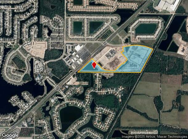
Property Record
5591 N 41 Hwy, Apollo Beach, FL 33572
NEARBY LISTINGS FOR SALE OR LEASE
-
-
View all Apollo Beach listings for sale on LoopNet.com
Property Detail
5591 N 41 Hwy
Tampa-St. Petersburg-Clearwater, FL
Unplatted
U-28-31-19-ZZZ-000001-75620.0
COMM AT SE COR OF SECTION 28 THN RUN N 89 DEG 28 MIN 33 SEC W 869.92 FT TO PT ON INTERSECTION WITH NWLY R/W LINE OF CSX R/RFOR A POB THN CONT N 89 DEG 28 MIN 33 SEC W 1778.21 FT TO S 1/4 COR OF SD SEC 28 THN N 89 DEG 17 MIN 18 SEC W 1042.42 FT TO PT
Miscellaneous
Hillsborough
AE
Florida
12057C0493J
75620
2024
36.50 AC
2024
Southeast Tampa
014106
Tampa/St Petersburg
DEMOGRAPHICS near 5591 N 41 Hwy
1 Mile
3 Mile
5 Mile
2024 Total Population
5,358
53,637
122,738
2029 Population
6,194
61,257
139,458
Pop Growth 2024-2029
+ 15.60%
+ 14.21%
+ 13.62%
Average Age
48
42
45
2024 Total Households
2,277
19,514
48,519
HH Growth 2024-2029
+ 15.24%
+ 14.46%
+ 13.60%
Median Household Inc
$106,643
$95,944
$76,400
Avg Household Size
2.40
2.70
2.50
2024 Avg HH Vehicles
2.00
2.00
2.00
Median Home Value
$394,698
$346,525
$279,494
Median Year Built
2010
2010
2006
Nearby Places
Map Layers
Map Styles
 Street
 Aerial
- Restaurants
- Banks
- Shops
- Fitness
- Groceries
PUBLIC TRANSPORTATION
AIRPORT
Tampa International
DRIVE
WALK
Distance
Tampa International
44 min
28.0 mi
Sarasota/Bradenton International
DRIVE
WALK
Distance
Sarasota/Bradenton International
49 min
30.6 mi
St Pete-Clearwater International
DRIVE
WALK
Distance
St Pete-Clearwater International
61 min
37.3 mi
Freight Ports
Port Manatee
DRIVE
WALK
Distance
Port Manatee
23 min
13.7 mi
Nearby Properties
Address
Land Use
TOTAL SIZE
Lot Size
Zoning
Address
Land Use
TOTAL SIZE
Lot Size
Zoning
1,026,563 SF
79.54 AC
PD
Address
Land Use
TOTAL SIZE
Lot Size
Zoning
503,703 SF
21 AC
PD
Address
Land Use
TOTAL SIZE
Lot Size
Zoning
351,758 SF
63.45 AC
PD
Address
Land Use
TOTAL SIZE
Lot Size
Zoning
334,559 SF
27.53 AC
PD
Address
Land Use
TOTAL SIZE
Lot Size
Zoning
35,855 SF
38.61 AC
PD
Address
Land Use
TOTAL SIZE
Lot Size
Zoning
154,232 SF
17.40 AC
PD
Address
Land Use
TOTAL SIZE
Lot Size
Zoning
290,432 SF
45.44 AC
PD
Address
Land Use
TOTAL SIZE
Lot Size
Zoning
138,397 SF
36.94 AC
PD
Address
Land Use
TOTAL SIZE
Lot Size
Zoning
64,512 SF
22.33 AC
PD
Address
Land Use
TOTAL SIZE
Lot Size
Zoning
77,315 SF
9.71 AC
CG
Address
Land Use
TOTAL SIZE
Lot Size
Zoning
478.28 AC
PD
Address
Land Use
TOTAL SIZE
Lot Size
Zoning
93,256 SF
14.82 AC
PD
Address
Land Use
TOTAL SIZE
Lot Size
Zoning
108,036 SF
11.70 AC
PD
Address
Land Use
TOTAL SIZE
Lot Size
Zoning
94,955 SF
13.55 AC
PD
Address
Land Use
TOTAL SIZE
Lot Size
Zoning
230,880 SF
25.13 AC
AI
Address
Land Use
TOTAL SIZE
Lot Size
Zoning
191,459 SF
13.60 AC
M
Address
Land Use
TOTAL SIZE
Lot Size
Zoning
58,368 SF
9.15 AC
PD
Address
Land Use
TOTAL SIZE
Lot Size
Zoning
137,465 SF
10.30 AC
PD
Address
Land Use
TOTAL SIZE
Lot Size
Zoning
131,647 SF
9.98 AC
PD
Address
Land Use
TOTAL SIZE
Lot Size
Zoning
51,900 SF
47.60 AC
PD
Address
Land Use
TOTAL SIZE
Lot Size
Zoning
61,680 SF
20.16 AC
PD
Address
Land Use
TOTAL SIZE
Lot Size
Zoning
1,325 SF
2.69 AC
PD
Address
Land Use
TOTAL SIZE
Lot Size
Zoning
89,847 SF
8.56 AC
PD
Address
Land Use
TOTAL SIZE
Lot Size
Zoning
113,683 SF
14.51 AC
PD
Address
Land Use
TOTAL SIZE
Lot Size
Zoning
131,155 SF
18.31 AC
PD
Address
Land Use
TOTAL SIZE
Lot Size
Zoning
76,280 SF
3.87 AC
PD
Address
Land Use
TOTAL SIZE
Lot Size
Zoning
41,031 SF
12.16 AC
CN
Address
Land Use
TOTAL SIZE
Lot Size
Zoning
97,398 SF
12.45 AC
RDC-12
Address
Land Use
TOTAL SIZE
Lot Size
Zoning
54,228 SF
2.85 AC
PD
Address
Land Use
TOTAL SIZE
Lot Size
Zoning
36,426 SF
20.23 AC
PD
The World's #1 Commercial Real Estate Marketplace
Connect with us
© 2026 CoStar Group
The information above has been obtained from sources believed reliable. While we do not doubt its accuracy we have not verified it and make no guarantee, warranty or representation about it. It is your responsibility to independently confirm its accuracy and completeness. Any projections, opinions, assumptions, or estimates used are for example only and do not represent the current or future performance of the property. The value of this transaction to you depends on tax and other factors which should be evaluated by your tax, financial, and legal advisors. You and your advisors should conduct a careful, independent investigation of the property to determine to your satisfaction the suitability of the property for your needs.