Property Record
5596 Nw Oak Hill Ave, Arcadia, FL 34266

NEARBY LISTINGS FOR SALE OR LEASE
Property Detail
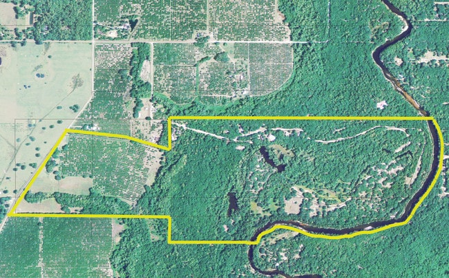
5596 Nw Oak Hill Ave
11-37-24-0000-0030-0000
SE1/4 OF NE1/4 E OF CLAY RD & N1/2 OF N1/2 OF NE1/4 OF SE1/4 E OF CLAY RD AND ALSO N1/2 OF N1/2 OF NW1/4 OF SE1/4 E OF CLAY RD LESS PARCELS 0035 & 0040 & LESS FPL ESMT OR 576/798 INST:202114006195
Pasture
DeSoto
A
Florida
12027C0044C
21 AC
2024
Florida Central South Area
2024
Other Market Areas
010404
Arcadia, FL
1,148 SF
DEMOGRAPHICS near 5596 Nw Oak Hill Ave
1 Mile
3 Mile
5 Mile
2024 Total Population
137
2,475
16,020
2029 Population
147
2,639
17,651
Pop Growth 2024-2029
+ 7.30%
+ 6.63%
+ 10.18%
Average Age
41
45
39
2024 Total Households
41
939
5,743
HH Growth 2024-2029
+ 7.32%
+ 7.24%
+ 10.92%
Median Household Inc
$23,749
$41,017
$29,791
Avg Household Size
2.70
2.40
2.70
2024 Avg HH Vehicles
2.00
2.00
2.00
Median Home Value
$156,249
$137,708
$128,889
Median Year Built
1990
1994
1986
Nearby Places
Map Layers
Map Styles
 Street
 Aerial
- Restaurants
- Banks
- Shops
- Fitness
- Groceries
PUBLIC TRANSPORTATION
AIRPORT
Punta Gorda
DRIVE
WALK
Distance
Punta Gorda
49 min
30.8 mi
Freight Ports
Port Manatee
DRIVE
WALK
Distance
Port Manatee
82 min
59.2 mi
SALE & LEASE HISTORY
LISTING DATE
SALE/LEASE

Feb 25, 2020
For Sale
Nearby Properties
Address
Land Use
TOTAL SIZE
Lot Size
Zoning
Address
Land Use
TOTAL SIZE
Lot Size
Zoning
9,092 SF
20.89 AC
TTRVC
Address
Land Use
TOTAL SIZE
Lot Size
Zoning
7,308 SF
48 AC
TTRVC
Address
Land Use
TOTAL SIZE
Lot Size
Zoning
8,376 SF
27.28 AC
A-10
Address
Land Use
TOTAL SIZE
Lot Size
Zoning
27,189 SF
39.50 AC
A-5
Address
Land Use
TOTAL SIZE
Lot Size
Zoning
23,212 SF
6.56 AC
RMF-M
Address
Land Use
TOTAL SIZE
Lot Size
Zoning
22,435 SF
10.51 AC
IL
Address
Land Use
TOTAL SIZE
Lot Size
Zoning
4,848 SF
14.05 AC
A-10
Address
Land Use
TOTAL SIZE
Lot Size
Zoning
660 SF
113.21 AC
A-5
Address
Land Use
TOTAL SIZE
Lot Size
Zoning
12,528 SF
159 AC
A-10
Address
Land Use
TOTAL SIZE
Lot Size
Zoning
9,872 SF
1.95 AC
A-10
Address
Land Use
TOTAL SIZE
Lot Size
Zoning
15,001 SF
6.44 AC
A-5
Address
Land Use
TOTAL SIZE
Lot Size
Zoning
27,450 SF
40 AC
A-5
Address
Land Use
TOTAL SIZE
Lot Size
Zoning
15,181 SF
10 AC
B-3
Address
Land Use
TOTAL SIZE
Lot Size
Zoning
25,436 SF
9.72 AC
IL
Address
Land Use
TOTAL SIZE
Lot Size
Zoning
80 AC
R-1A
Address
Land Use
TOTAL SIZE
Lot Size
Zoning
6,612 SF
10 AC
A-10
Address
Land Use
TOTAL SIZE
Lot Size
Zoning
3,017 SF
47.16 AC
A-10
Address
Land Use
TOTAL SIZE
Lot Size
Zoning
4,818 SF
17.76 AC
A-10
Address
Land Use
TOTAL SIZE
Lot Size
Zoning
1,188 SF
75 AC
A-10
Address
Land Use
TOTAL SIZE
Lot Size
Zoning
72.89 AC
A-10
Address
Land Use
TOTAL SIZE
Lot Size
Zoning
10,729 SF
2.22 AC
CN
Address
Land Use
TOTAL SIZE
Lot Size
Zoning
2,356 SF
31.39 AC
RMF-6
Address
Land Use
TOTAL SIZE
Lot Size
Zoning
3,430 SF
9.64 AC
R-1A
Address
Land Use
TOTAL SIZE
Lot Size
Zoning
4,939 SF
2.09 AC
MHP
Address
Land Use
TOTAL SIZE
Lot Size
Zoning
51.22 AC
A-10
Address
Land Use
TOTAL SIZE
Lot Size
Zoning
110 AC
A-5
Address
Land Use
TOTAL SIZE
Lot Size
Zoning
3,188 SF
40 AC
A-10
Address
Land Use
TOTAL SIZE
Lot Size
Zoning
351.93 AC
A-10
Address
Land Use
TOTAL SIZE
Lot Size
Zoning
984 SF
133.36 AC
A-10
Address
Land Use
TOTAL SIZE
Lot Size
Zoning
3,108 SF
7.29 AC
A-5
The World's #1 Commercial Real Estate Marketplace
Connect with us
© 2025 CoStar Group
The information above has been obtained from sources believed reliable. While we do not doubt its accuracy we have not verified it and make no guarantee, warranty or representation about it. It is your responsibility to independently confirm its accuracy and completeness. Any projections, opinions, assumptions, or estimates used are for example only and do not represent the current or future performance of the property. The value of this transaction to you depends on tax and other factors which should be evaluated by your tax, financial, and legal advisors. You and your advisors should conduct a careful, independent investigation of the property to determine to your satisfaction the suitability of the property for your needs.