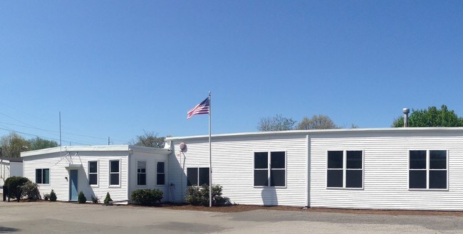
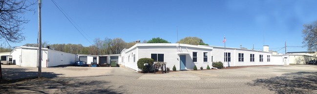
Property Record
55R Pawtucket Ave, Rumford, RI 02916
NEARBY LISTINGS FOR SALE OR LEASE
Property Detail
55R Pawtucket Ave
EPRO-000302-000001-000034
Providence
Industrialgeneral
Rhode Island
X
33
44007C0326J
1.20 AC
2025
East Providence
2025
Providence
010101
Providence-Warwick, RI-MA
64,836 SF
DEMOGRAPHICS near 55R Pawtucket Ave
1 Mile
3 Mile
5 Mile
2024 Total Population
10,178
156,754
339,506
2029 Population
10,208
155,180
336,005
Pop Growth 2024-2029
+ 0.29%
(1.00%)
(1.03%)
Average Age
42
39
38
2024 Total Households
4,249
63,641
134,771
HH Growth 2024-2029
+ 0.24%
(1.05%)
(1.00%)
Median Household Inc
$71,319
$63,904
$62,655
Avg Household Size
2.30
2.30
2.40
2024 Avg HH Vehicles
2.00
1.00
1.00
Median Home Value
$281,159
$302,208
$306,167
Median Year Built
1957
1948
1949
Nearby Places
Map Layers
Map Styles
 Street
 Aerial
- Restaurants
- Banks
- Shops
- Fitness
- Groceries
PUBLIC TRANSPORTATION
COMMUTER RAIL
Pawtucket/Central Falls (Foxboro Event Service - MBTA, Providence/Stoughton Line - MBTA)
DRIVE
WALK
Distance
Pawtucket/Central Falls (Foxboro Event Service - MBTA, Providence/Stoughton Line - MBTA)
5 min
2.7 mi
Providence (Providence/Stoughton Line - Massachusetts Bay Transportation Authority Commuter Rail (Purple Line))
DRIVE
WALK
Distance
Providence (Providence/Stoughton Line - Massachusetts Bay Transportation Authority Commuter Rail (Purple Line))
12 min
6.0 mi
AIRPORT
Rhode Island Tf Green International
DRIVE
WALK
Distance
Rhode Island Tf Green International
25 min
12.9 mi
Freight Ports
Port of Davisville, RI
DRIVE
WALK
Distance
Port of Davisville, RI
41 min
25.2 mi
SALE & LEASE HISTORY
LISTING DATE
SALE/LEASE

Nov 09, 2017
For Sale
Nearby Properties
Address
Land Use
TOTAL SIZE
Lot Size
Zoning
Address
Land Use
TOTAL SIZE
Lot Size
Zoning
45,407 SF
38.03 AC
I-2
Address
Land Use
TOTAL SIZE
Lot Size
Zoning
19.69 AC
R-1
Address
Land Use
TOTAL SIZE
Lot Size
Zoning
317,728 SF
28.20 AC
O1
Address
Land Use
TOTAL SIZE
Lot Size
Zoning
79.57 AC
O1
Address
Land Use
TOTAL SIZE
Lot Size
Zoning
170,531 SF
3 AC
M-2
Address
Land Use
TOTAL SIZE
Lot Size
Zoning
205,551 SF
1.38 AC
C-2
Address
Land Use
TOTAL SIZE
Lot Size
Zoning
6.39 AC
I-2
Address
Land Use
TOTAL SIZE
Lot Size
Zoning
18.51 AC
PS
Address
Land Use
TOTAL SIZE
Lot Size
Zoning
2.01 AC
I-2
Address
Land Use
TOTAL SIZE
Lot Size
Zoning
57,688 SF
0.46 AC
I-2
Address
Land Use
TOTAL SIZE
Lot Size
Zoning
4.21 AC
I-2
Address
Land Use
TOTAL SIZE
Lot Size
Zoning
4.88 AC
I-2
Address
Land Use
TOTAL SIZE
Lot Size
Zoning
140,769 SF
5.37 AC
PS
Address
Land Use
TOTAL SIZE
Lot Size
Zoning
2.01 AC
I-2
Address
Land Use
TOTAL SIZE
Lot Size
Zoning
95,064 SF
1.38 AC
I-2
Address
Land Use
TOTAL SIZE
Lot Size
Zoning
255,438 SF
174 SF
I-1-75
Address
Land Use
TOTAL SIZE
Lot Size
Zoning
270,505 SF
2.85 AC
D-1-75
Address
Land Use
TOTAL SIZE
Lot Size
Zoning
193.69 AC
PO
Address
Land Use
TOTAL SIZE
Lot Size
Zoning
1,274 SF
99.20 AC
OS
Address
Land Use
TOTAL SIZE
Lot Size
Zoning
2.91 AC
I-2
Address
Land Use
TOTAL SIZE
Lot Size
Zoning
101,060 SF
0.66 AC
I-2
Address
Land Use
TOTAL SIZE
Lot Size
Zoning
1.67 AC
I-2
Address
Land Use
TOTAL SIZE
Lot Size
Zoning
2.20 AC
I-2
Address
Land Use
TOTAL SIZE
Lot Size
Zoning
168,150 SF
2.77 AC
PO
Address
Land Use
TOTAL SIZE
Lot Size
Zoning
116,311 SF
0.22 AC
D-1-10
Address
Land Use
TOTAL SIZE
Lot Size
Zoning
1.03 AC
I-2
Address
Land Use
TOTAL SIZE
Lot Size
Zoning
38.09 AC
CD
Address
Land Use
TOTAL SIZE
Lot Size
Zoning
3.08 AC
R-3
Address
Land Use
TOTAL SIZE
Lot Size
Zoning
116,080 SF
0.77 AC
C-2
Address
Land Use
TOTAL SIZE
Lot Size
Zoning
21 AC
RM
The World's #1 Commercial Real Estate Marketplace
Connect with us
© 2025 CoStar Group
The information above has been obtained from sources believed reliable. While we do not doubt its accuracy we have not verified it and make no guarantee, warranty or representation about it. It is your responsibility to independently confirm its accuracy and completeness. Any projections, opinions, assumptions, or estimates used are for example only and do not represent the current or future performance of the property. The value of this transaction to you depends on tax and other factors which should be evaluated by your tax, financial, and legal advisors. You and your advisors should conduct a careful, independent investigation of the property to determine to your satisfaction the suitability of the property for your needs.