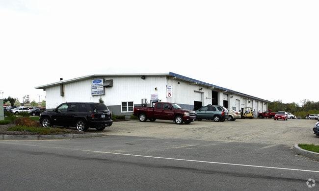
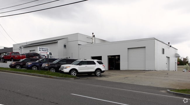
Property Record
56 Gilcreast Rd, Londonderry, NH 03053
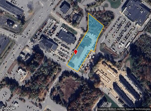
NEARBY LISTINGS FOR SALE OR LEASE
Property Detail
56 Gilcreast Rd
LOND-000007-000000-000073-000009
Rockingham
Autorepair
New Hampshire
X
73-9
33015C0526E
2.32 AC
2024
Rockingham
2024
Boston
003701
Boston-Cambridge-Newton, MA-NH
12,000 SF
DEMOGRAPHICS near 56 Gilcreast Rd
1 Mile
3 Mile
5 Mile
2024 Total Population
3,420
33,639
63,543
2029 Population
3,557
34,882
65,852
Pop Growth 2024-2029
+ 4.01%
+ 3.70%
+ 3.63%
Average Age
43
41
41
2024 Total Households
1,432
13,342
23,930
HH Growth 2024-2029
+ 3.98%
+ 3.58%
+ 3.54%
Median Household Inc
$87,556
$96,408
$110,621
Avg Household Size
2.30
2.50
2.60
2024 Avg HH Vehicles
2.00
2.00
2.00
Median Home Value
$336,956
$362,045
$398,426
Median Year Built
1982
1980
1982
Nearby Places
Map Layers
Map Styles
 Street
 Aerial
- Restaurants
- Banks
- Shops
- Fitness
- Groceries
PUBLIC TRANSPORTATION
AIRPORT
Manchester Boston Regional
DRIVE
WALK
Distance
Manchester Boston Regional
22 min
9.2 mi
Freight Ports
Port of Boston
DRIVE
WALK
Distance
Port of Boston
68 min
46.0 mi
Nearby Properties
Address
Land Use
TOTAL SIZE
Lot Size
Zoning
Address
Land Use
TOTAL SIZE
Lot Size
Zoning
43.88 AC
MHDR
Address
Land Use
TOTAL SIZE
Lot Size
Zoning
15.44 AC
AR-I
Address
Land Use
TOTAL SIZE
Lot Size
Zoning
1,710 SF
65 AC
AR-I
Address
Land Use
TOTAL SIZE
Lot Size
Zoning
214,583 SF
110.37 AC
AR-I
Address
Land Use
TOTAL SIZE
Lot Size
Zoning
54.56 AC
MFR
Address
Land Use
TOTAL SIZE
Lot Size
Zoning
186,072 SF
18.64 AC
C-I
Address
Land Use
TOTAL SIZE
Lot Size
Zoning
146,407 SF
15.39 AC
OMB
Address
Land Use
TOTAL SIZE
Lot Size
Zoning
40.50 AC
MDR
Address
Land Use
TOTAL SIZE
Lot Size
Zoning
133,188 SF
1.53 AC
AR-I
Address
Land Use
TOTAL SIZE
Lot Size
Zoning
12.94 AC
MFR
Address
Land Use
TOTAL SIZE
Lot Size
Zoning
23.03 AC
GC
Address
Land Use
TOTAL SIZE
Lot Size
Zoning
166,979 SF
22.08 AC
MHDR
Address
Land Use
TOTAL SIZE
Lot Size
Zoning
12.73 AC
C-I
Address
Land Use
TOTAL SIZE
Lot Size
Zoning
117,412 SF
12.86 AC
C-II
Address
Land Use
TOTAL SIZE
Lot Size
Zoning
33.45 AC
IND4
Address
Land Use
TOTAL SIZE
Lot Size
Zoning
30.26 AC
C-I
Address
Land Use
TOTAL SIZE
Lot Size
Zoning
154,551 SF
55.80 AC
IND4
Address
Land Use
TOTAL SIZE
Lot Size
Zoning
31.14 AC
AR-I
Address
Land Use
TOTAL SIZE
Lot Size
Zoning
195,610 SF
20.49 AC
C-I
Address
Land Use
TOTAL SIZE
Lot Size
Zoning
22.09 AC
AR-I
Address
Land Use
TOTAL SIZE
Lot Size
Zoning
90,406 SF
24.78 AC
AR-I
Address
Land Use
TOTAL SIZE
Lot Size
Zoning
108,248 SF
5.92 AC
OMB
Address
Land Use
TOTAL SIZE
Lot Size
Zoning
80,710 SF
20 AC
AR-I
Address
Land Use
TOTAL SIZE
Lot Size
Zoning
41,989 SF
C-III
Address
Land Use
TOTAL SIZE
Lot Size
Zoning
79,447 SF
6.83 AC
GC2
Address
Land Use
TOTAL SIZE
Lot Size
Zoning
69,266 SF
6.02 AC
MHDR
Address
Land Use
TOTAL SIZE
Lot Size
Zoning
42,956 SF
2.31 AC
Address
Land Use
TOTAL SIZE
Lot Size
Zoning
60,572 SF
5.65 AC
C-I
Address
Land Use
TOTAL SIZE
Lot Size
Zoning
11.28 AC
C-I
Address
Land Use
TOTAL SIZE
Lot Size
Zoning
16.50 AC
C-II
The World's #1 Commercial Real Estate Marketplace
Connect with us
© 2025 CoStar Group
The information above has been obtained from sources believed reliable. While we do not doubt its accuracy we have not verified it and make no guarantee, warranty or representation about it. It is your responsibility to independently confirm its accuracy and completeness. Any projections, opinions, assumptions, or estimates used are for example only and do not represent the current or future performance of the property. The value of this transaction to you depends on tax and other factors which should be evaluated by your tax, financial, and legal advisors. You and your advisors should conduct a careful, independent investigation of the property to determine to your satisfaction the suitability of the property for your needs.