Property Record
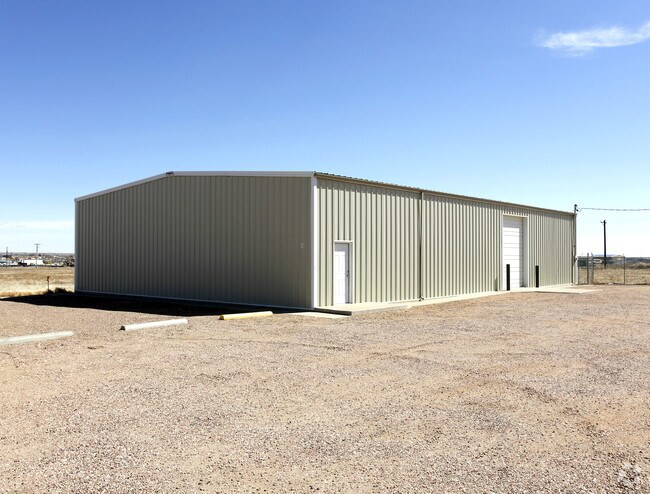
56 N Precision Dr, Pueblo, CO 81007


NEARBY LISTINGS FOR SALE OR LEASE
Property Detail
56 N Precision Dr
0-6-01-0-08-031
Com-Pueblo West Ip
Farms
PARCEL A LOT LINE VACATION NO 2015-008 FORMERLY,#06-010-08-007 + 008
X
Pueblo
08101C0478D
Colorado
2024
2 AC
2024
Colorado East Area
002923
Other Market Areas
4,000 SF
Pueblo, CO
DEMOGRAPHICS near 56 N Precision Dr
1 Mile
3 Mile
5 Mile
2024 Total Population
1,944
20,911
34,485
2029 Population
1,992
21,404
35,447
Pop Growth 2024-2029
+ 2.47%
+ 2.36%
+ 2.79%
Average Age
37
40
41
2024 Total Households
708
7,780
12,797
HH Growth 2024-2029
+ 2.68%
+ 2.40%
+ 2.87%
Median Household Inc
$64,218
$79,072
$82,578
Avg Household Size
2.70
2.60
2.60
2024 Avg HH Vehicles
2.00
2.00
2.00
Median Home Value
$283,540
$296,648
$316,613
Median Year Built
1993
1996
1998
Nearby Places
Map Layers
Map Styles
 Street
 Aerial
- Restaurants
- Banks
- Shops
- Fitness
- Groceries
Nearby Properties
Address
Land Use
TOTAL SIZE
Lot Size
Zoning
Address
Land Use
TOTAL SIZE
Lot Size
Zoning
78,127 SF
34.84 AC
R-5
Address
Land Use
TOTAL SIZE
Lot Size
Zoning
60,593 SF
12.69 AC
Address
Land Use
TOTAL SIZE
Lot Size
Zoning
221,954 SF
24.02 AC
B-4
Address
Land Use
TOTAL SIZE
Lot Size
Zoning
15,284 SF
4.50 AC
R6:RES/MUL
Address
Land Use
TOTAL SIZE
Lot Size
Zoning
33,098 SF
5 AC
B4:COMM/RE
Address
Land Use
TOTAL SIZE
Lot Size
Zoning
34,494 SF
3.87 AC
R5:RES/MUL
Address
Land Use
TOTAL SIZE
Lot Size
Zoning
8,166 SF
8.27 AC
R-6
Address
Land Use
TOTAL SIZE
Lot Size
Zoning
79,400 SF
5.83 AC
I-2
Address
Land Use
TOTAL SIZE
Lot Size
Zoning
7,495 SF
2.99 AC
R5:RES/MUL
Address
Land Use
TOTAL SIZE
Lot Size
Zoning
51,856 SF
6.01 AC
Address
Land Use
TOTAL SIZE
Lot Size
Zoning
3,146 SF
46.55 AC
S1:SPC/PUB
Address
Land Use
TOTAL SIZE
Lot Size
Zoning
107,280 SF
6.22 AC
I-2
Address
Land Use
TOTAL SIZE
Lot Size
Zoning
37.11 AC
S1:SPC/PUB
Address
Land Use
TOTAL SIZE
Lot Size
Zoning
33.01 AC
S1:SPC/PUB
Address
Land Use
TOTAL SIZE
Lot Size
Zoning
22,077 SF
13.98 AC
S1:SPC/PUB
Address
Land Use
TOTAL SIZE
Lot Size
Zoning
29,720 SF
2.28 AC
B4:COMM/RE
Address
Land Use
TOTAL SIZE
Lot Size
Zoning
30.47 AC
S1:SPC/PUB
Address
Land Use
TOTAL SIZE
Lot Size
Zoning
10,030 SF
1.72 AC
B4:COMM/RE
Address
Land Use
TOTAL SIZE
Lot Size
Zoning
20.39 AC
I2:IND/MAN
Address
Land Use
TOTAL SIZE
Lot Size
Zoning
56,140 SF
5.60 AC
B4:COMM/RE
Address
Land Use
TOTAL SIZE
Lot Size
Zoning
19.74 AC
I2:IND/MAN
Address
Land Use
TOTAL SIZE
Lot Size
Zoning
54,100 SF
4.60 AC
I2:IND/MAN
Address
Land Use
TOTAL SIZE
Lot Size
Zoning
19.41 AC
I2:IND/MAN
Address
Land Use
TOTAL SIZE
Lot Size
Zoning
32.46 AC
B4:COMM/RE
Address
Land Use
TOTAL SIZE
Lot Size
Zoning
5,682 SF
4.23 AC
R6:RES/MUL
Address
Land Use
TOTAL SIZE
Lot Size
Zoning
62,080 SF
3.11 AC
I-2
Address
Land Use
TOTAL SIZE
Lot Size
Zoning
34,950 SF
8.26 AC
R6:RES/MUL
Address
Land Use
TOTAL SIZE
Lot Size
Zoning
25.34 AC
S1:SPC/PUB
Address
Land Use
TOTAL SIZE
Lot Size
Zoning
53,200 SF
10.34 AC
I2:IND/MAN
Address
Land Use
TOTAL SIZE
Lot Size
Zoning
21,394 SF
1.38 AC
B4:COMM/RE
The World's #1 Commercial Real Estate Marketplace
Connect with us
© 2026 CoStar Group
The information above has been obtained from sources believed reliable. While we do not doubt its accuracy we have not verified it and make no guarantee, warranty or representation about it. It is your responsibility to independently confirm its accuracy and completeness. Any projections, opinions, assumptions, or estimates used are for example only and do not represent the current or future performance of the property. The value of this transaction to you depends on tax and other factors which should be evaluated by your tax, financial, and legal advisors. You and your advisors should conduct a careful, independent investigation of the property to determine to your satisfaction the suitability of the property for your needs.