Property Record
56 Payne Rd, Lebanon, NJ 08833


NEARBY LISTINGS FOR SALE OR LEASE
-
-
View all Lebanon listings for sale on LoopNet.com
Property Detail
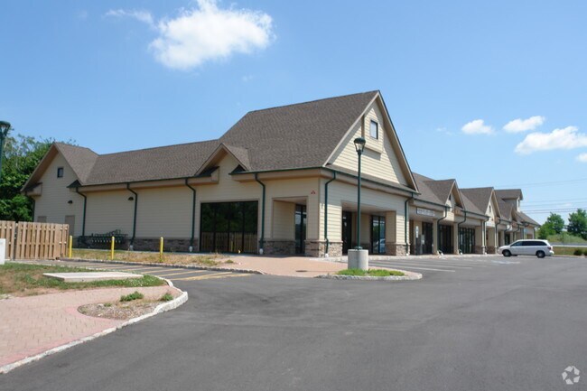
56 Payne Rd
Newark, NJ-PA
ADDITIONAL LOTS: 15600SF STRIP CENTER
06-00089-0000-00008
Hunterdon
Regionalshoppingcenterormallwithanchorstore
New Jersey
X
8
34019C0255F
3.05 AC
2024
Hunterdon
2025
Northern New Jersey
011003
DEMOGRAPHICS near 56 Payne Rd
1 Mile
3 Mile
5 Mile
2024 Total Population
1,725
10,034
31,269
2029 Population
1,742
10,150
31,678
Pop Growth 2024-2029
+ 0.99%
+ 1.16%
+ 1.31%
Average Age
42
45
44
2024 Total Households
574
3,803
11,471
HH Growth 2024-2029
+ 1.05%
+ 1.29%
+ 1.50%
Median Household Inc
$175,000
$148,235
$136,259
Avg Household Size
3.00
2.60
2.60
2024 Avg HH Vehicles
3.00
2.00
2.00
Median Home Value
$543,367
$513,584
$477,250
Median Year Built
1980
1983
1980
Nearby Places
Map Layers
Map Styles
 Street
 Aerial
- Restaurants
- Banks
- Shops
- Fitness
- Groceries
PUBLIC TRANSPORTATION
COMMUTER RAIL
Annandale (Raritan Valley Line - NJ Transit Commuter Rail (NJ Transit))
DRIVE
WALK
Distance
Annandale (Raritan Valley Line - NJ Transit Commuter Rail (NJ Transit))
8 min
3.9 mi
Lebanon (Raritan Valley Line - NJ Transit Commuter Rail (NJ Transit))
DRIVE
WALK
Distance
Lebanon (Raritan Valley Line - NJ Transit Commuter Rail (NJ Transit))
12 min
6.5 mi
AIRPORT
Trenton Mercer
DRIVE
WALK
Distance
Trenton Mercer
43 min
25.4 mi
Lehigh Valley International
DRIVE
WALK
Distance
Lehigh Valley International
54 min
36.6 mi
Freight Ports
Maher Terminal
DRIVE
WALK
Distance
Maher Terminal
60 min
46.4 mi
Nearby Properties
Address
Land Use
TOTAL SIZE
Lot Size
Zoning
Address
Land Use
TOTAL SIZE
Lot Size
Zoning
84.62 AC
ROM1
Address
Land Use
TOTAL SIZE
Lot Size
Zoning
3,703.19 AC
RC
Address
Land Use
TOTAL SIZE
Lot Size
Zoning
49.26 AC
RR4S
Address
Land Use
TOTAL SIZE
Lot Size
Zoning
6 AC
ROM1
Address
Land Use
TOTAL SIZE
Lot Size
Zoning
9,408 SF
37 AC
ROM1
Address
Land Use
TOTAL SIZE
Lot Size
Zoning
10.20 AC
OB1
Address
Land Use
TOTAL SIZE
Lot Size
Zoning
244 SF
29.92 AC
RR4S
Address
Land Use
TOTAL SIZE
Lot Size
Zoning
10.44 AC
PUD
Address
Land Use
TOTAL SIZE
Lot Size
Zoning
2,087 SF
4.12 AC
ROM2
Address
Land Use
TOTAL SIZE
Lot Size
Zoning
6,618 SF
43.45 AC
RC
Address
Land Use
TOTAL SIZE
Lot Size
Zoning
5.80 AC
OB1
Address
Land Use
TOTAL SIZE
Lot Size
Zoning
98.91 AC
ROM1
Address
Land Use
TOTAL SIZE
Lot Size
Zoning
24.14 AC
AR-7
Address
Land Use
TOTAL SIZE
Lot Size
Zoning
15,876 SF
1.94 AC
ROM1
Address
Land Use
TOTAL SIZE
Lot Size
Zoning
22,358 SF
2.81 AC
C1
Address
Land Use
TOTAL SIZE
Lot Size
Zoning
3,683 SF
4.84 AC
C1
Address
Land Use
TOTAL SIZE
Lot Size
Zoning
8,148 SF
7.75 AC
R-1
Address
Land Use
TOTAL SIZE
Lot Size
Zoning
11,460 SF
2 AC
RR50
Address
Land Use
TOTAL SIZE
Lot Size
Zoning
7.11 AC
RR4S
Address
Land Use
TOTAL SIZE
Lot Size
Zoning
2.77 AC
OB1
Address
Land Use
TOTAL SIZE
Lot Size
Zoning
10,352 SF
85.65 AC
RC
Address
Land Use
TOTAL SIZE
Lot Size
Zoning
2.69 AC
C1
Address
Land Use
TOTAL SIZE
Lot Size
Zoning
2,760 SF
90.55 AC
RC
Address
Land Use
TOTAL SIZE
Lot Size
Zoning
14,120 SF
2.20 AC
OB1
Address
Land Use
TOTAL SIZE
Lot Size
Zoning
44.20 AC
ROM1
Address
Land Use
TOTAL SIZE
Lot Size
Zoning
2,420 SF
68.70 AC
SRR
Address
Land Use
TOTAL SIZE
Lot Size
Zoning
8,106 SF
4 AC
RC
Address
Land Use
TOTAL SIZE
Lot Size
Zoning
0.39 AC
PUD
Address
Land Use
TOTAL SIZE
Lot Size
Zoning
7,974 SF
2 AC
RR50
The World's #1 Commercial Real Estate Marketplace
Connect with us
© 2025 CoStar Group
The information above has been obtained from sources believed reliable. While we do not doubt its accuracy we have not verified it and make no guarantee, warranty or representation about it. It is your responsibility to independently confirm its accuracy and completeness. Any projections, opinions, assumptions, or estimates used are for example only and do not represent the current or future performance of the property. The value of this transaction to you depends on tax and other factors which should be evaluated by your tax, financial, and legal advisors. You and your advisors should conduct a careful, independent investigation of the property to determine to your satisfaction the suitability of the property for your needs.