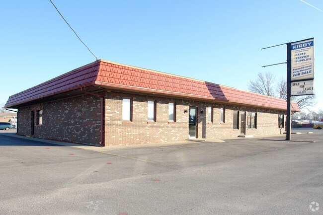
Property Record
560 E Springhill Dr, Terre Haute, IN 47802


Save to a Folder
{{folder.Name}}
{{folder.ListingIds.length}} Properties
{{folder.ListingIds.length}} Property
Create a New Folder
Property Detail
560 E Springhill Dr
84-09-09-278-024.000-004
W SIDE SW SW SE NE D-396/243 9-11-9 .60 AC
Publicstorage
VIGO
AE The base floodplain where base flood elevations are provided. AE Zones are now used on new format FIRMs instead of A1-A30 Zones.
Indiana
2025
0.65 AC
2025
Bloomington/Terre Haute
011201
Other Market Areas
6,600 SF
Terre Haute, IN
NEARBY LISTINGS FOR SALE OR LEASE
DEMOGRAPHICS near 560 E Springhill Dr
1 mile
3 mile
5 mile
2025 Total Population
3,648
25,064
61,000
2030 Population
3,663
24,979
61,370
Pop Growth 2025-2030
+ 0.41%
(0.34%)
+ 0.61%
Average Age
42
40
38
2025 Total Households
1,702
9,606
23,836
HH Growth 2025-2030
+ 0.41%
(0.42%)
+ 0.74%
Median Household Inc
$41,487
$47,012
$43,831
Avg Household Size
2.10
2.20
2.20
2025 Avg HH Vehicles
2.00
2.00
2.00
Median Home Value
$147,977
$147,578
$132,929
Median Year Built
1983
1975
1971
Nearby Places
Map Layers
Map Styles
 Street
 Aerial
Layers
 Traffic
 Biking
Places
Listings with unknown addresses are not visible on the map
- Restaurants
- Banks
- Shops
- Fitness
- Groceries
Nearby Properties
Address
Land Use
TOTAL SIZE
Lot Size
Zoning
Address
Land Use
TOTAL SIZE
Lot Size
Zoning
174,674 SF
20.53 AC
Address
Land Use
TOTAL SIZE
Lot Size
Zoning
20,400 SF
131.99 AC
Address
Land Use
TOTAL SIZE
Lot Size
Zoning
72,804 SF
22.28 AC
Address
Land Use
TOTAL SIZE
Lot Size
Zoning
199,297 SF
24.64 AC
Address
Land Use
TOTAL SIZE
Lot Size
Zoning
1,881 SF
21.39 AC
Address
Land Use
TOTAL SIZE
Lot Size
Zoning
15,586 SF
8.75 AC
Address
Land Use
TOTAL SIZE
Lot Size
Zoning
13,360 SF
9.44 AC
Address
Land Use
TOTAL SIZE
Lot Size
Zoning
13,360 SF
10.93 AC
Address
Land Use
TOTAL SIZE
Lot Size
Zoning
263,122 SF
14.80 AC
Address
Land Use
TOTAL SIZE
Lot Size
Zoning
156,558 SF
15.77 AC
Address
Land Use
TOTAL SIZE
Lot Size
Zoning
227,038 SF
22.09 AC
Address
Land Use
TOTAL SIZE
Lot Size
Zoning
18,226 SF
8 AC
Address
Land Use
TOTAL SIZE
Lot Size
Zoning
63,979 SF
5.47 AC
Address
Land Use
TOTAL SIZE
Lot Size
Zoning
93,774 SF
8.71 AC
Address
Land Use
TOTAL SIZE
Lot Size
Zoning
77,170 SF
1.53 AC
Address
Land Use
TOTAL SIZE
Lot Size
Zoning
47,432 SF
13.50 AC
Address
Land Use
TOTAL SIZE
Lot Size
Zoning
2,516 SF
14.31 AC
Address
Land Use
TOTAL SIZE
Lot Size
Zoning
9,443 SF
4.33 AC
Address
Land Use
TOTAL SIZE
Lot Size
Zoning
53,196 SF
2.21 AC
Address
Land Use
TOTAL SIZE
Lot Size
Zoning
111,744 SF
9.33 AC
Address
Land Use
TOTAL SIZE
Lot Size
Zoning
29,679 SF
4.77 AC
Address
Land Use
TOTAL SIZE
Lot Size
Zoning
111,948 SF
9.88 AC
Address
Land Use
TOTAL SIZE
Lot Size
Zoning
131,981 SF
17.33 AC
Address
Land Use
TOTAL SIZE
Lot Size
Zoning
28,311 SF
40 AC
Address
Land Use
TOTAL SIZE
Lot Size
Zoning
39,600 SF
3.95 AC
Address
Land Use
TOTAL SIZE
Lot Size
Zoning
27,104 SF
0.45 AC
Address
Land Use
TOTAL SIZE
Lot Size
Zoning
63,416 SF
1.40 AC
Address
Land Use
TOTAL SIZE
Lot Size
Zoning
8,128 SF
3.46 AC
Address
Land Use
TOTAL SIZE
Lot Size
Zoning
9,424 SF
28.17 AC
Address
Land Use
TOTAL SIZE
Lot Size
Zoning
23,049 SF
6.75 AC
The World's #1 Commercial Real Estate Marketplace
Connect with us
© 2026 CoStar Group
The information above has been obtained from sources believed reliable. While we do not doubt its accuracy we have not verified it and make no guarantee, warranty or representation about it. It is your responsibility to independently confirm its accuracy and completeness. Any projections, opinions, assumptions, or estimates used are for example only and do not represent the current or future performance of the property. The value of this transaction to you depends on tax and other factors which should be evaluated by your tax, financial, and legal advisors. You and your advisors should conduct a careful, independent investigation of the property to determine to your satisfaction the suitability of the property for your needs.