Property Record
560 River St, Haverhill, MA 01832
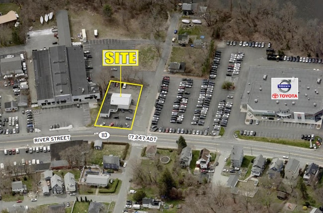

Property Detail
560 River St
HAVE-000508-000260-000008
ESSEX
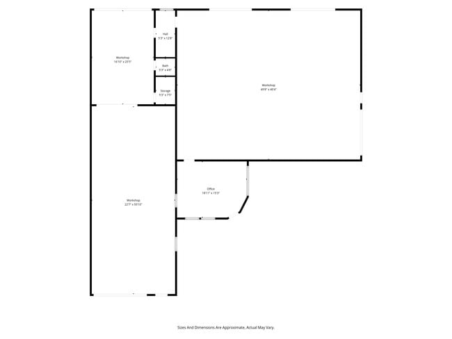
Autorepair
Massachusetts
C and X Area of minimal flood hazard, usually depicted on FIRMs as above the 500-year flood level.
8
2025
0.47 AC
2025
Lawrence/Andover
260900
Boston
4,184 SF
Boston-Cambridge-Newton, MA-NH
NEARBY LISTINGS FOR SALE OR LEASE
DEMOGRAPHICS near 560 River St
1 mile
3 mile
5 mile
2025 Total Population
13,717
69,829
163,237
2030 Population
13,879
71,109
165,743
Pop Growth 2025-2030
+ 1.18%
+ 1.83%
+ 1.54%
Average Age
38
40
40
2025 Total Households
5,248
27,402
60,214
HH Growth 2025-2030
+ 1.24%
+ 1.86%
+ 1.64%
Median Household Inc
$83,305
$82,257
$85,913
Avg Household Size
2.50
2.50
2.60
2025 Avg HH Vehicles
2.00
2.00
2.00
Median Home Value
$407,626
$454,636
$486,495
Median Year Built
1965
1966
1965
Nearby Places
Map Layers
Map Styles
 Street
 Aerial
Layers
 Traffic
 Biking
Places
Listings with unknown addresses are not visible on the map
- Restaurants
- Banks
- Shops
- Fitness
- Groceries
PUBLIC TRANSPORTATION
COMMUTER RAIL
Haverhill (Haverhill Line - Massachusetts Bay Transportation Authority Commuter Rail (Purple Line))
Drive
Walk
Distance
Haverhill (Haverhill Line - Massachusetts Bay Transportation Authority Commuter Rail (Purple Line))
2 min
1.2 mi
Bradford (Haverhill Line - Massachusetts Bay Transportation Authority Commuter Rail (Purple Line))
Drive
Walk
Distance
Bradford (Haverhill Line - Massachusetts Bay Transportation Authority Commuter Rail (Purple Line))
3 min
1.4 mi
AIRPORT
Manchester Boston Regional
Drive
Walk
Distance
Manchester Boston Regional
45 min
30.0 mi
Portsmouth International at Pease
Drive
Walk
Distance
Portsmouth International at Pease
43 min
30.9 mi
General Edward Lawrence Logan International
Drive
Walk
Distance
General Edward Lawrence Logan International
49 min
37.1 mi
Freight Ports
Port of Boston
Drive
Walk
Distance
Port of Boston
50 min
36.8 mi
SALE & LEASE HISTORY
LISTING DATE
SALE/LEASE

Feb 26, 2025
For Sale
Feb 26, 2025
For Lease
Nearby Properties
Address
Land Use
TOTAL SIZE
Lot Size
Zoning
Address
Land Use
TOTAL SIZE
Lot Size
Zoning
110.12 AC
I2
Address
Land Use
TOTAL SIZE
Lot Size
Zoning
3,000 SF
44.13 AC
IL
Address
Land Use
TOTAL SIZE
Lot Size
Zoning
30.72 AC
Address
Land Use
TOTAL SIZE
Lot Size
Zoning
32.32 AC
Address
Land Use
TOTAL SIZE
Lot Size
Zoning
232,420 SF
4.58 AC
Address
Land Use
TOTAL SIZE
Lot Size
Zoning
358,890 SF
5.72 AC
Address
Land Use
TOTAL SIZE
Lot Size
Zoning
Address
Land Use
TOTAL SIZE
Lot Size
Zoning
195,120 SF
9.05 AC
Address
Land Use
TOTAL SIZE
Lot Size
Zoning
226,309 SF
19.33 AC
R3
Address
Land Use
TOTAL SIZE
Lot Size
Zoning
260,720 SF
57.68 AC
I2
Address
Land Use
TOTAL SIZE
Lot Size
Zoning
187,600 SF
19.31 AC
Address
Land Use
TOTAL SIZE
Lot Size
Zoning
173,788 SF
16.30 AC
Address
Land Use
TOTAL SIZE
Lot Size
Zoning
21.91 AC
Address
Land Use
TOTAL SIZE
Lot Size
Zoning
19.90 AC
Address
Land Use
TOTAL SIZE
Lot Size
Zoning
121,231 SF
1.11 AC
Address
Land Use
TOTAL SIZE
Lot Size
Zoning
248,592 SF
27.74 AC
I2
Address
Land Use
TOTAL SIZE
Lot Size
Zoning
200,081 SF
1.95 AC
Address
Land Use
TOTAL SIZE
Lot Size
Zoning
72,019 SF
10.74 AC
Address
Land Use
TOTAL SIZE
Lot Size
Zoning
21,752 SF
5.28 AC
Address
Land Use
TOTAL SIZE
Lot Size
Zoning
26.60 AC
Address
Land Use
TOTAL SIZE
Lot Size
Zoning
17.95 AC
Address
Land Use
TOTAL SIZE
Lot Size
Zoning
201,526 SF
24 AC
Address
Land Use
TOTAL SIZE
Lot Size
Zoning
159,058 SF
7.46 AC
Address
Land Use
TOTAL SIZE
Lot Size
Zoning
5.82 AC
Address
Land Use
TOTAL SIZE
Lot Size
Zoning
106,323 SF
2.05 AC
Address
Land Use
TOTAL SIZE
Lot Size
Zoning
142,845 SF
20.99 AC
Address
Land Use
TOTAL SIZE
Lot Size
Zoning
69,094 SF
0.54 AC
Address
Land Use
TOTAL SIZE
Lot Size
Zoning
119,956 SF
9.54 AC
Address
Land Use
TOTAL SIZE
Lot Size
Zoning
88,943 SF
2.43 AC
Address
Land Use
TOTAL SIZE
Lot Size
Zoning
202,022 SF
13.29 AC
The World's #1 Commercial Real Estate Marketplace
Connect with us
© 2026 CoStar Group
The information above has been obtained from sources believed reliable. While we do not doubt its accuracy we have not verified it and make no guarantee, warranty or representation about it. It is your responsibility to independently confirm its accuracy and completeness. Any projections, opinions, assumptions, or estimates used are for example only and do not represent the current or future performance of the property. The value of this transaction to you depends on tax and other factors which should be evaluated by your tax, financial, and legal advisors. You and your advisors should conduct a careful, independent investigation of the property to determine to your satisfaction the suitability of the property for your needs.