Property Record
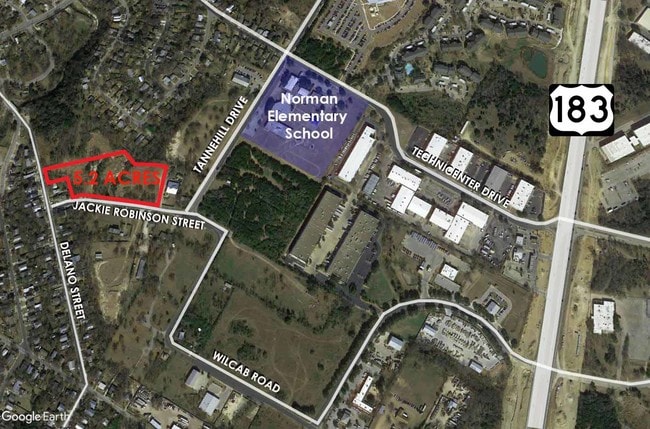
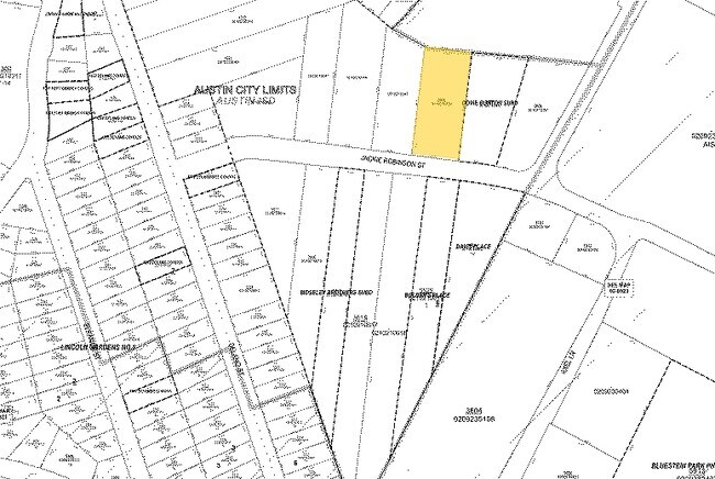
5600 Jackie Robinson St, Austin, TX 78721
Property Detail
5600 Jackie Robinson St
Austin-Round Rock-San Marcos, TX
NORTH JACKIE ROBINSON SUBD LOT 1
201193
TRAVIS
Vacantlandnec
Texas
B and X Area of moderate flood hazard, usually the area between the limits of the 100-year and 500-year floods.
1
2025
8.03 AC
2025
East
002110
Austin
NEARBY LISTINGS FOR SALE OR LEASE
DEMOGRAPHICS near 5600 Jackie Robinson St
1 mile
3 mile
5 mile
2025 Total Population
9,715
94,000
302,777
2030 Population
10,215
99,926
320,337
Pop Growth 2025-2030
+ 5.15%
+ 6.30%
+ 5.80%
Average Age
38
37
35
2025 Total Households
3,577
38,170
132,342
HH Growth 2025-2030
+ 5.76%
+ 7.04%
+ 6.61%
Median Household Inc
$107,356
$97,888
$81,268
Avg Household Size
2.40
2.30
2.10
2025 Avg HH Vehicles
2.00
2.00
2.00
Median Home Value
$585,348
$620,664
$642,832
Median Year Built
1992
2001
1999
Nearby Places
Map Layers
Map Styles
 Street
 Aerial
Transit
 Traffic
 Biking
Places
Listings with unknown addresses are not visible on the map
- Restaurants
- Banks
- Shops
- Fitness
- Groceries
PUBLIC TRANSPORTATION
COMMUTER RAIL
Austin (Texas Eagle - Amtrak)
Drive
Walk
Distance
Austin (Texas Eagle - Amtrak)
14 min
6.3 mi
AIRPORT
Austin-Bergstrom International
Drive
Walk
Distance
Austin-Bergstrom International
22 min
10.7 mi
Freight Ports
Calhoun Port
Drive
Walk
Distance
Calhoun Port
187 min
154.2 mi
SALE & LEASE HISTORY
LISTING DATE
SALE/LEASE

Feb 12, 2024
For Sale
Dec 18, 2018
For Sale
Nearby Properties
Address
Land Use
TOTAL SIZE
Lot Size
Zoning
Address
Land Use
TOTAL SIZE
Lot Size
Zoning
9,768 SF
386.80 AC
Address
Land Use
TOTAL SIZE
Lot Size
Zoning
548,399 SF
23.82 AC
Address
Land Use
TOTAL SIZE
Lot Size
Zoning
832,892 SF
30.12 AC
Address
Land Use
TOTAL SIZE
Lot Size
Zoning
22.14 AC
Address
Land Use
TOTAL SIZE
Lot Size
Zoning
39.25 AC
Address
Land Use
TOTAL SIZE
Lot Size
Zoning
91,836 SF
19.80 AC
Address
Land Use
TOTAL SIZE
Lot Size
Zoning
19,284 SF
178.26 AC
Address
Land Use
TOTAL SIZE
Lot Size
Zoning
17.37 AC
Address
Land Use
TOTAL SIZE
Lot Size
Zoning
241,998 SF
2.42 AC
Address
Land Use
TOTAL SIZE
Lot Size
Zoning
322,150 SF
3.83 AC
Address
Land Use
TOTAL SIZE
Lot Size
Zoning
432,032 SF
6.70 AC
Address
Land Use
TOTAL SIZE
Lot Size
Zoning
609,823 SF
3.33 AC
Address
Land Use
TOTAL SIZE
Lot Size
Zoning
372,075 SF
4.97 AC
Address
Land Use
TOTAL SIZE
Lot Size
Zoning
265,000 SF
1.57 AC
Address
Land Use
TOTAL SIZE
Lot Size
Zoning
91,639 SF
35.97 AC
Address
Land Use
TOTAL SIZE
Lot Size
Zoning
297,356 SF
4.32 AC
Address
Land Use
TOTAL SIZE
Lot Size
Zoning
283,800 SF
4.05 AC
Address
Land Use
TOTAL SIZE
Lot Size
Zoning
288,750 SF
4.81 AC
Address
Land Use
TOTAL SIZE
Lot Size
Zoning
190,546 SF
5.85 AC
Address
Land Use
TOTAL SIZE
Lot Size
Zoning
296,378 SF
3.72 AC
Address
Land Use
TOTAL SIZE
Lot Size
Zoning
301,125 SF
5.23 AC
Address
Land Use
TOTAL SIZE
Lot Size
Zoning
31,357 SF
37.73 AC
Address
Land Use
TOTAL SIZE
Lot Size
Zoning
126.15 AC
Address
Land Use
TOTAL SIZE
Lot Size
Zoning
302,967 SF
8.31 AC
Address
Land Use
TOTAL SIZE
Lot Size
Zoning
236,503 SF
6.86 AC
Address
Land Use
TOTAL SIZE
Lot Size
Zoning
292,431 SF
2.33 AC
Address
Land Use
TOTAL SIZE
Lot Size
Zoning
19.76 AC
Address
Land Use
TOTAL SIZE
Lot Size
Zoning
300,300 SF
3.72 AC
Address
Land Use
TOTAL SIZE
Lot Size
Zoning
274,943 SF
42.35 AC
Address
Land Use
TOTAL SIZE
Lot Size
Zoning
The World's #1 Commercial Real Estate Marketplace
Connect with us
© 2026 CoStar Group
The information above has been obtained from sources believed reliable. While we do not doubt its accuracy we have not verified it and make no guarantee, warranty or representation about it. It is your responsibility to independently confirm its accuracy and completeness. Any projections, opinions, assumptions, or estimates used are for example only and do not represent the current or future performance of the property. The value of this transaction to you depends on tax and other factors which should be evaluated by your tax, financial, and legal advisors. You and your advisors should conduct a careful, independent investigation of the property to determine to your satisfaction the suitability of the property for your needs.