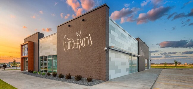
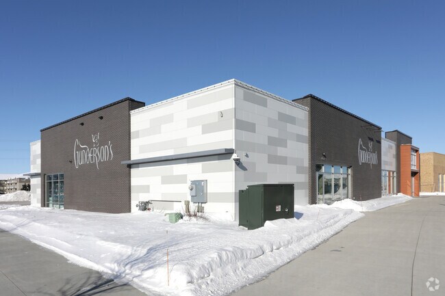
Property Record
5601 28Th Ave S, Fargo, ND 58104

Save to a Folder
{{folder.Name}}
{{folder.ListingIds.length}} Properties
{{folder.ListingIds.length}} Property
Create a New Folder
Property Detail
5601 28Th Ave S
Fargo, ND-MN
LOT: 2 BLOCK: 1 ADDITION: URBAN PLAINS BY BRANDT 4TH ADDITION ADDITIONAL: URBAN PLAINS BY BRANDT 4TH LT 2 BLK 1 **2-28-20
01-8729-00200-000
Cass
Commercialnec
North Dakota
C and X Area of minimal flood hazard, usually depicted on FIRMs as above the 500-year flood level.
2
2025
0.87 AC
2025
Fargo
040700
Other Market Areas
NEARBY LISTINGS FOR SALE OR LEASE
DEMOGRAPHICS near 5601 28Th Ave S
1 mile
3 mile
5 mile
2025 Total Population
14,193
94,295
149,477
2030 Population
15,282
100,769
159,710
Pop Growth 2025-2030
+ 7.67%
+ 6.87%
+ 6.85%
Average Age
32
35
36
2025 Total Households
6,276
40,784
64,744
HH Growth 2025-2030
+ 8.16%
+ 7.16%
+ 7.04%
Median Household Inc
$81,678
$76,960
$74,907
Avg Household Size
2.20
2.30
2.20
2025 Avg HH Vehicles
2.00
2.00
2.00
Median Home Value
$444,761
$324,124
$301,304
Median Year Built
2011
2004
1999
Nearby Places
Map Layers
Map Styles
 Street
 Aerial
Layers
 Traffic
 Biking
Places
Listings with unknown addresses are not visible on the map
- Restaurants
- Banks
- Shops
- Fitness
- Groceries
PUBLIC TRANSPORTATION
COMMUTER RAIL
Drive
Walk
Distance
14 min
7.5 mi
AIRPORT
Hector International
Drive
Walk
Distance
Hector International
19 min
10.5 mi
Nearby Properties
Address
Land Use
TOTAL SIZE
Lot Size
Zoning
Address
Land Use
TOTAL SIZE
Lot Size
Zoning
408,617 SF
9.33 AC
GC
Address
Land Use
TOTAL SIZE
Lot Size
Zoning
55.68 AC
Address
Land Use
TOTAL SIZE
Lot Size
Zoning
Address
Land Use
TOTAL SIZE
Lot Size
Zoning
Address
Land Use
TOTAL SIZE
Lot Size
Zoning
Address
Land Use
TOTAL SIZE
Lot Size
Zoning
418,024 SF
10.88 AC
Address
Land Use
TOTAL SIZE
Lot Size
Zoning
230,272 SF
21.77 AC
GC
Address
Land Use
TOTAL SIZE
Lot Size
Zoning
Address
Land Use
TOTAL SIZE
Lot Size
Zoning
7.66 AC
Address
Land Use
TOTAL SIZE
Lot Size
Zoning
Address
Land Use
TOTAL SIZE
Lot Size
Zoning
163,195 SF
11.95 AC
GC
Address
Land Use
TOTAL SIZE
Lot Size
Zoning
Address
Land Use
TOTAL SIZE
Lot Size
Zoning
45.33 AC
GC
Address
Land Use
TOTAL SIZE
Lot Size
Zoning
Address
Land Use
TOTAL SIZE
Lot Size
Zoning
131,309 SF
6.62 AC
GC
Address
Land Use
TOTAL SIZE
Lot Size
Zoning
217,776 SF
31.82 AC
GC
Address
Land Use
TOTAL SIZE
Lot Size
Zoning
34,100 SF
1.46 AC
MR3
Address
Land Use
TOTAL SIZE
Lot Size
Zoning
9,279 SF
8.33 AC
MR1
Address
Land Use
TOTAL SIZE
Lot Size
Zoning
48,300 SF
2.33 AC
MR3
Address
Land Use
TOTAL SIZE
Lot Size
Zoning
30,240 SF
1.54 AC
MR2
Address
Land Use
TOTAL SIZE
Lot Size
Zoning
152,509 SF
18.14 AC
Address
Land Use
TOTAL SIZE
Lot Size
Zoning
152,918 SF
5.38 AC
Address
Land Use
TOTAL SIZE
Lot Size
Zoning
Address
Land Use
TOTAL SIZE
Lot Size
Zoning
73,907 SF
3.41 AC
MR3
Address
Land Use
TOTAL SIZE
Lot Size
Zoning
146,131 SF
15.67 AC
GO
Address
Land Use
TOTAL SIZE
Lot Size
Zoning
54,927 SF
8.45 AC
Address
Land Use
TOTAL SIZE
Lot Size
Zoning
46,271 SF
2.06 AC
MR3
Address
Land Use
TOTAL SIZE
Lot Size
Zoning
104,817 SF
13.93 AC
GC
Address
Land Use
TOTAL SIZE
Lot Size
Zoning
123,777 SF
1.90 AC
Address
Land Use
TOTAL SIZE
Lot Size
Zoning
387,326 SF
16.51 AC
GC
The World's #1 Commercial Real Estate Marketplace
Connect with us
© 2026 CoStar Group
The information above has been obtained from sources believed reliable. While we do not doubt its accuracy we have not verified it and make no guarantee, warranty or representation about it. It is your responsibility to independently confirm its accuracy and completeness. Any projections, opinions, assumptions, or estimates used are for example only and do not represent the current or future performance of the property. The value of this transaction to you depends on tax and other factors which should be evaluated by your tax, financial, and legal advisors. You and your advisors should conduct a careful, independent investigation of the property to determine to your satisfaction the suitability of the property for your needs.