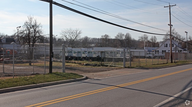
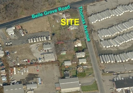
Property Record
5601 Belle Grove Rd, Brooklyn, MD 21225

Property Detail
5601 Belle Grove Rd
05-000-09094400
PT LTS 1 2 THOMAS TRACT
Commercialnec
Anne Arundel
W2
Maryland
C and X Area of minimal flood hazard, usually depicted on FIRMs as above the 500-year flood level.
1
2024
0.51 AC
2025
BWI North/Linthicum
750201
Baltimore
1,265 SF
Baltimore-Columbia-Towson, MD
NEARBY LISTINGS FOR SALE OR LEASE
DEMOGRAPHICS near 5601 Belle Grove Rd
1 mile
3 mile
5 mile
2025 Total Population
9,801
91,230
232,700
2030 Population
9,844
91,242
233,509
Pop Growth 2025-2030
+ 0.44%
+ 0.01%
+ 0.35%
Average Age
39
38
38
2025 Total Households
3,504
33,298
95,476
HH Growth 2025-2030
+ 0.43%
+ 0.04%
+ 0.21%
Median Household Inc
$80,220
$68,789
$78,487
Avg Household Size
2.70
2.60
2.40
2025 Avg HH Vehicles
2.00
2.00
1.00
Median Home Value
$281,001
$281,198
$307,150
Median Year Built
1957
1958
1957
Nearby Places
Map Layers
Map Styles
 Street
 Aerial
Layers
 Traffic
 Biking
Places
Listings with unknown addresses are not visible on the map
- Restaurants
- Banks
- Shops
- Fitness
- Groceries
PUBLIC TRANSPORTATION
TRANSIT/SUBWAY
Nursery Road (Hunt Valley & BWI Marshall - Maryland Transit Administration Light Rail (Baltimore Light Rail), Timonium & Cromwell - Maryland Transit Administration Light Rail (Baltimore Light Rail))
Drive
Walk
Distance
Nursery Road (Hunt Valley & BWI Marshall - Maryland Transit Administration Light Rail (Baltimore Light Rail), Timonium & Cromwell - Maryland Transit Administration Light Rail (Baltimore Light Rail))
4 min
18 min
0.9 mi
COMMUTER RAIL
Halethorpe Marc Nb (PENN - WASHINGTON - Maryland Transit Administration)
Drive
Walk
Distance
Halethorpe Marc Nb (PENN - WASHINGTON - Maryland Transit Administration)
12 min
6.0 mi
Halethorpe Marc Sb (PENN - WASHINGTON - Maryland Transit Administration)
Drive
Walk
Distance
Halethorpe Marc Sb (PENN - WASHINGTON - Maryland Transit Administration)
12 min
6.0 mi
AIRPORT
Baltimore/Washington International Thurgood Marshall
Drive
Walk
Distance
Baltimore/Washington International Thurgood Marshall
12 min
5.0 mi
Freight Ports
Port of Baltimore
Drive
Walk
Distance
Port of Baltimore
12 min
4.9 mi
SALE & LEASE HISTORY
LISTING DATE
SALE/LEASE

Nov 07, 2021
For Lease
Nearby Properties
Address
Land Use
TOTAL SIZE
Lot Size
Zoning
Address
Land Use
TOTAL SIZE
Lot Size
Zoning
467.03 AC
W2
Address
Land Use
TOTAL SIZE
Lot Size
Zoning
430,940 SF
18.81 AC
MXDT
Address
Land Use
TOTAL SIZE
Lot Size
Zoning
520,407 SF
16.85 AC
H
Address
Land Use
TOTAL SIZE
Lot Size
Zoning
305,483 SF
11.38 AC
MXDT
Address
Land Use
TOTAL SIZE
Lot Size
Zoning
383,697 SF
68.35 AC
R5
Address
Land Use
TOTAL SIZE
Lot Size
Zoning
289,829 SF
24.56 AC
C3
Address
Land Use
TOTAL SIZE
Lot Size
Zoning
231,128 SF
8.30 AC
W1-BW
Address
Land Use
TOTAL SIZE
Lot Size
Zoning
19.20 AC
R15
Address
Land Use
TOTAL SIZE
Lot Size
Zoning
12.90 AC
R15
Address
Land Use
TOTAL SIZE
Lot Size
Zoning
233,408 SF
24.73 AC
C3
Address
Land Use
TOTAL SIZE
Lot Size
Zoning
263,024 SF
6.87 AC
C3
Address
Land Use
TOTAL SIZE
Lot Size
Zoning
18.86 AC
DR16
Address
Land Use
TOTAL SIZE
Lot Size
Zoning
173,735 SF
17.31 AC
PC-4
Address
Land Use
TOTAL SIZE
Lot Size
Zoning
41.14 AC
W1-BW
Address
Land Use
TOTAL SIZE
Lot Size
Zoning
16.26 AC
R15
Address
Land Use
TOTAL SIZE
Lot Size
Zoning
15.05 AC
R15
Address
Land Use
TOTAL SIZE
Lot Size
Zoning
187,814 SF
38.47 AC
R5
Address
Land Use
TOTAL SIZE
Lot Size
Zoning
239,476 SF
19.02 AC
MI
Address
Land Use
TOTAL SIZE
Lot Size
Zoning
12 AC
C3
Address
Land Use
TOTAL SIZE
Lot Size
Zoning
116,600 SF
8.97 AC
C4
Address
Land Use
TOTAL SIZE
Lot Size
Zoning
101,220 SF
17.51 AC
DR5.5
Address
Land Use
TOTAL SIZE
Lot Size
Zoning
194,652 SF
20.49 AC
W1-BW
Address
Land Use
TOTAL SIZE
Lot Size
Zoning
190,650 SF
20.80 AC
I-2
Address
Land Use
TOTAL SIZE
Lot Size
Zoning
19.86 AC
DR16
Address
Land Use
TOTAL SIZE
Lot Size
Zoning
10.92 AC
R15
Address
Land Use
TOTAL SIZE
Lot Size
Zoning
227,704 SF
23.52 AC
C4
Address
Land Use
TOTAL SIZE
Lot Size
Zoning
265,423 SF
22.26 AC
MI
Address
Land Use
TOTAL SIZE
Lot Size
Zoning
86,587 SF
9.86 AC
W1-BW
Address
Land Use
TOTAL SIZE
Lot Size
Zoning
132,000 SF
29.26 AC
ML
Address
Land Use
TOTAL SIZE
Lot Size
Zoning
209,044 SF
17.28 AC
C3
The World's #1 Commercial Real Estate Marketplace
Connect with us
© 2026 CoStar Group
The information above has been obtained from sources believed reliable. While we do not doubt its accuracy we have not verified it and make no guarantee, warranty or representation about it. It is your responsibility to independently confirm its accuracy and completeness. Any projections, opinions, assumptions, or estimates used are for example only and do not represent the current or future performance of the property. The value of this transaction to you depends on tax and other factors which should be evaluated by your tax, financial, and legal advisors. You and your advisors should conduct a careful, independent investigation of the property to determine to your satisfaction the suitability of the property for your needs.