Property Record
5601 Cedars Rd, Redding, CA 96001
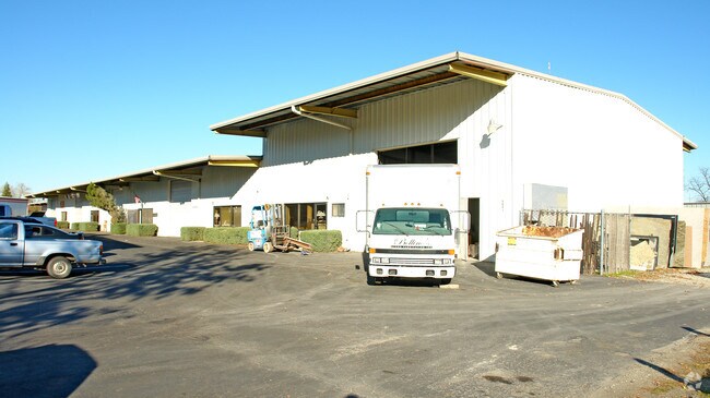

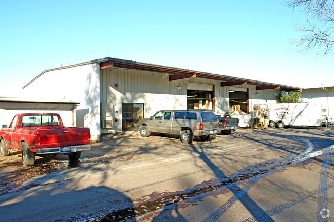
Property Detail
5601 Cedars Rd
049-130-030-000
SHASTA
Miscellaneous
California
B and X Area of moderate flood hazard, usually the area between the limits of the 100-year and 500-year floods.
3.04 AC
2024
Other Market Areas
2025
Redding, CA
011002
NEARBY LISTINGS FOR SALE OR LEASE
DEMOGRAPHICS near 5601 Cedars Rd
1 mile
3 mile
5 mile
2024 Total Population
4,530
32,431
86,950
2029 Population
4,582
32,611
87,270
Pop Growth 2024-2029
+ 1.15%
+ 0.56%
+ 0.37%
Average Age
41
41
41
2024 Total Households
1,748
12,545
34,546
HH Growth 2024-2029
+ 1.20%
+ 0.58%
+ 0.37%
Median Household Inc
$73,691
$79,151
$77,232
Avg Household Size
2.50
2.40
2.40
2024 Avg HH Vehicles
2.00
2.00
2.00
Median Home Value
$351,134
$361,870
$377,610
Median Year Built
1972
1978
1981
Nearby Places
Map Layers
Map Styles
 Street
 Aerial
Transit
 Traffic
 Biking
Places
Listings with unknown addresses are not visible on the map
- Restaurants
- Banks
- Shops
- Fitness
- Groceries
PUBLIC TRANSPORTATION
COMMUTER RAIL
Redding Amtrak (Coast Starlight - Amtrak)
Drive
Walk
Distance
Redding Amtrak (Coast Starlight - Amtrak)
9 min
4.1 mi
AIRPORT
Redding Regional
Drive
Walk
Distance
Redding Regional
13 min
7.3 mi
Freight Ports
Port of Richmond
Drive
Walk
Distance
Port of Richmond
229 min
201.8 mi
Nearby Properties
Address
Land Use
TOTAL SIZE
Lot Size
Zoning
Address
Land Use
TOTAL SIZE
Lot Size
Zoning
15.20 AC
Address
Land Use
TOTAL SIZE
Lot Size
Zoning
151,773 SF
17.64 AC
Address
Land Use
TOTAL SIZE
Lot Size
Zoning
47,062 SF
4.80 AC
Address
Land Use
TOTAL SIZE
Lot Size
Zoning
81,800 SF
14.81 AC
Address
Land Use
TOTAL SIZE
Lot Size
Zoning
50,251 SF
4.06 AC
Address
Land Use
TOTAL SIZE
Lot Size
Zoning
61,754 SF
1.73 AC
Address
Land Use
TOTAL SIZE
Lot Size
Zoning
92,699 SF
5.91 AC
Address
Land Use
TOTAL SIZE
Lot Size
Zoning
344.24 AC
U
Address
Land Use
TOTAL SIZE
Lot Size
Zoning
11.90 AC
Address
Land Use
TOTAL SIZE
Lot Size
Zoning
16,320 SF
3.76 AC
Address
Land Use
TOTAL SIZE
Lot Size
Zoning
11.80 AC
Address
Land Use
TOTAL SIZE
Lot Size
Zoning
4.20 AC
Address
Land Use
TOTAL SIZE
Lot Size
Zoning
50,609 SF
4.62 AC
Address
Land Use
TOTAL SIZE
Lot Size
Zoning
90,832 SF
12.44 AC
C-2
Address
Land Use
TOTAL SIZE
Lot Size
Zoning
65,920 SF
11.34 AC
Address
Land Use
TOTAL SIZE
Lot Size
Zoning
3,178 SF
3.58 AC
Address
Land Use
TOTAL SIZE
Lot Size
Zoning
46,114 SF
2.93 AC
Address
Land Use
TOTAL SIZE
Lot Size
Zoning
2,400 SF
13 AC
Address
Land Use
TOTAL SIZE
Lot Size
Zoning
75,145 SF
5.95 AC
Address
Land Use
TOTAL SIZE
Lot Size
Zoning
2.50 AC
Address
Land Use
TOTAL SIZE
Lot Size
Zoning
7.26 AC
Address
Land Use
TOTAL SIZE
Lot Size
Zoning
7.29 AC
Address
Land Use
TOTAL SIZE
Lot Size
Zoning
28,051 SF
1.53 AC
Address
Land Use
TOTAL SIZE
Lot Size
Zoning
840 SF
109.09 AC
Address
Land Use
TOTAL SIZE
Lot Size
Zoning
3.43 AC
Address
Land Use
TOTAL SIZE
Lot Size
Zoning
3.50 AC
M-L
Address
Land Use
TOTAL SIZE
Lot Size
Zoning
4.61 AC
Address
Land Use
TOTAL SIZE
Lot Size
Zoning
28,712 SF
2.60 AC
Address
Land Use
TOTAL SIZE
Lot Size
Zoning
31,328 SF
4.50 AC
Address
Land Use
TOTAL SIZE
Lot Size
Zoning
5,005 SF
4.64 AC
The World's #1 Commercial Real Estate Marketplace
Connect with us
© 2026 CoStar Group
The information above has been obtained from sources believed reliable. While we do not doubt its accuracy we have not verified it and make no guarantee, warranty or representation about it. It is your responsibility to independently confirm its accuracy and completeness. Any projections, opinions, assumptions, or estimates used are for example only and do not represent the current or future performance of the property. The value of this transaction to you depends on tax and other factors which should be evaluated by your tax, financial, and legal advisors. You and your advisors should conduct a careful, independent investigation of the property to determine to your satisfaction the suitability of the property for your needs.