Property Record
5601 Rockfish Rd, Hope Mills, NC 28348


NEARBY LISTINGS FOR SALE OR LEASE
-
-
View all Hope Mills listings for lease on LoopNet.com
Property Detail
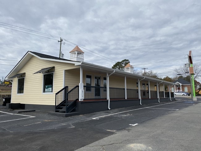
5601 Rockfish Rd
Fayetteville, NC
Hope Mills Proper
0414-45-7855
ALL AMERICAN WEIGHT LOSS & WELLNESS LO:1 PL:00150-0045
Officebuilding
Cumberland
X
North Carolina
3720041400J
7855
2025
0.32 AC
2025
Southwest Fayetteville
001605
Fayetteville
2,400 SF
DEMOGRAPHICS near 5601 Rockfish Rd
1 Mile
3 Mile
5 Mile
2024 Total Population
4,921
45,179
104,310
2029 Population
4,853
44,905
103,931
Pop Growth 2024-2029
(1.38%)
(0.61%)
(0.36%)
Average Age
38
35
36
2024 Total Households
1,995
16,935
39,538
HH Growth 2024-2029
(1.35%)
(0.60%)
(0.36%)
Median Household Inc
$48,468
$54,370
$57,539
Avg Household Size
2.40
2.60
2.60
2024 Avg HH Vehicles
2.00
2.00
2.00
Median Home Value
$148,938
$152,810
$162,383
Median Year Built
1986
1992
1988
Nearby Places
Map Layers
Map Styles
 Street
 Aerial
- Restaurants
- Banks
- Shops
- Fitness
- Groceries
PUBLIC TRANSPORTATION
COMMUTER RAIL
DRIVE
WALK
Distance
15 min
8.0 mi
AIRPORT
Fayetteville Regional/Grannis Field
DRIVE
WALK
Distance
Fayetteville Regional/Grannis Field
11 min
6.4 mi
SALE & LEASE HISTORY
LISTING DATE
SALE/LEASE

Dec 06, 2019
For Lease
Aug 10, 2018
For Sale
Nearby Properties
Address
Land Use
TOTAL SIZE
Lot Size
Zoning
Address
Land Use
TOTAL SIZE
Lot Size
Zoning
2,370 SF
15.66 AC
PND
Address
Land Use
TOTAL SIZE
Lot Size
Zoning
56,622 SF
104.70 AC
R10
Address
Land Use
TOTAL SIZE
Lot Size
Zoning
14,000 SF
97.50 AC
MP
Address
Land Use
TOTAL SIZE
Lot Size
Zoning
66,637 SF
25.83 AC
RR
Address
Land Use
TOTAL SIZE
Lot Size
Zoning
120,262 SF
12.45 AC
CP
Address
Land Use
TOTAL SIZE
Lot Size
Zoning
182,425 SF
23.13 AC
CP
Address
Land Use
TOTAL SIZE
Lot Size
Zoning
121,079 SF
15.39 AC
CP
Address
Land Use
TOTAL SIZE
Lot Size
Zoning
7,418 SF
10 AC
OIP
Address
Land Use
TOTAL SIZE
Lot Size
Zoning
54,706 SF
27.30 AC
R10
Address
Land Use
TOTAL SIZE
Lot Size
Zoning
2,476 SF
7.36 AC
R5A
Address
Land Use
TOTAL SIZE
Lot Size
Zoning
2,126 SF
6.67 AC
MXDCU
Address
Land Use
TOTAL SIZE
Lot Size
Zoning
12,550 SF
6.87 AC
RR
Address
Land Use
TOTAL SIZE
Lot Size
Zoning
26,366 SF
1.35 AC
MXD
Address
Land Use
TOTAL SIZE
Lot Size
Zoning
21.10 AC
MP
Address
Land Use
TOTAL SIZE
Lot Size
Zoning
88,383 SF
13.30 AC
CC
Address
Land Use
TOTAL SIZE
Lot Size
Zoning
9,404 SF
62.05 AC
RR
Address
Land Use
TOTAL SIZE
Lot Size
Zoning
53,351 SF
5.90 AC
CP
Address
Land Use
TOTAL SIZE
Lot Size
Zoning
51,180 SF
26 AC
R6
Address
Land Use
TOTAL SIZE
Lot Size
Zoning
8,754 SF
4.46 AC
R5A
Address
Land Use
TOTAL SIZE
Lot Size
Zoning
2,347 SF
7.22 AC
R5A
Address
Land Use
TOTAL SIZE
Lot Size
Zoning
1,970 SF
5.04 AC
R5A
Address
Land Use
TOTAL SIZE
Lot Size
Zoning
6,477 SF
10.71 AC
CPCU
Address
Land Use
TOTAL SIZE
Lot Size
Zoning
3,236 SF
16.32 AC
R6
Address
Land Use
TOTAL SIZE
Lot Size
Zoning
19,420 SF
14.04 AC
PND
Address
Land Use
TOTAL SIZE
Lot Size
Zoning
2,499 SF
5.15 AC
R10
Address
Land Use
TOTAL SIZE
Lot Size
Zoning
49,085 SF
16.55 AC
R10
Address
Land Use
TOTAL SIZE
Lot Size
Zoning
29,750 SF
1.86 AC
CP
Address
Land Use
TOTAL SIZE
Lot Size
Zoning
7,246 SF
10.01 AC
RRCZ-RURAL
Address
Land Use
TOTAL SIZE
Lot Size
Zoning
8,950 SF
1.19 AC
CP
Address
Land Use
TOTAL SIZE
Lot Size
Zoning
1,200 SF
11.40 AC
CP
The World's #1 Commercial Real Estate Marketplace
Connect with us
© 2026 CoStar Group
The information above has been obtained from sources believed reliable. While we do not doubt its accuracy we have not verified it and make no guarantee, warranty or representation about it. It is your responsibility to independently confirm its accuracy and completeness. Any projections, opinions, assumptions, or estimates used are for example only and do not represent the current or future performance of the property. The value of this transaction to you depends on tax and other factors which should be evaluated by your tax, financial, and legal advisors. You and your advisors should conduct a careful, independent investigation of the property to determine to your satisfaction the suitability of the property for your needs.