Property Record
5602 Cavalcade St, Houston, TX 77026


Save to a Folder
{{folder.Name}}
{{folder.ListingIds.length}} Properties
{{folder.ListingIds.length}} Property
Create a New Folder
This Property Is For Sale
Property Detail
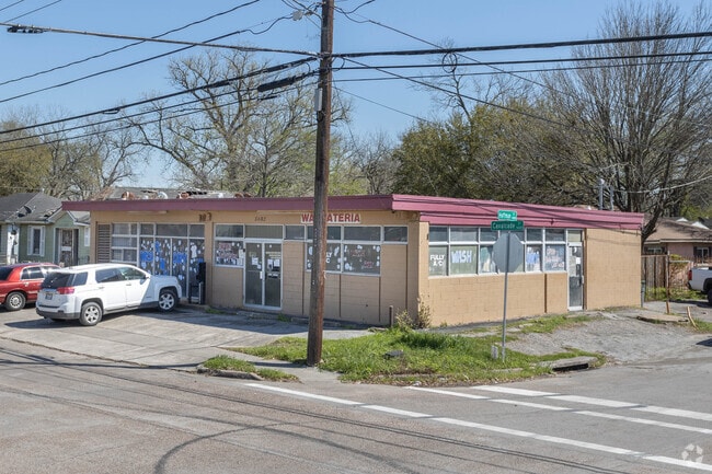
5602 Cavalcade St
0690650040096
TR 96 BLK 4 LIBERTY GARDENS EXTN SEC 1
Storebuilding
HARRIS
AE The base floodplain where base flood elevations are provided. AE Zones are now used on new format FIRMs instead of A1-A30 Zones.
Texas
2025
0.12 AC
2025
Inner Loop East End
211700
Houston
2,160 SF
Houston-Pasadena-The Woodlands, TX
NEARBY LISTINGS FOR SALE OR LEASE
DEMOGRAPHICS near 5602 Cavalcade St
1 mile
3 mile
5 mile
2025 Total Population
10,868
98,834
311,700
2030 Population
11,912
107,251
336,592
Pop Growth 2025-2030
+ 9.61%
+ 8.52%
+ 7.99%
Average Age
39
38
38
2025 Total Households
4,108
34,671
114,571
HH Growth 2025-2030
+ 9.76%
+ 8.77%
+ 8.61%
Median Household Inc
$30,432
$42,098
$57,123
Avg Household Size
2.60
2.80
2.60
2025 Avg HH Vehicles
1.00
2.00
2.00
Median Home Value
$154,115
$170,669
$243,370
Median Year Built
1963
1961
1965
Nearby Places
Map Layers
Map Styles
 Street
 Aerial
Layers
 Traffic
 Biking
Places
Listings with unknown addresses are not visible on the map
- Restaurants
- Banks
- Shops
- Fitness
- Groceries
PUBLIC TRANSPORTATION
AIRPORT
William P Hobby
Drive
Walk
Distance
William P Hobby
29 min
16.5 mi
George Bush Intcntl/Houston
Drive
Walk
Distance
George Bush Intcntl/Houston
23 min
16.6 mi
Nearby Properties
Address
Land Use
TOTAL SIZE
Lot Size
Zoning
Address
Land Use
TOTAL SIZE
Lot Size
Zoning
12,206,592 SF
212.18 AC
Address
Land Use
TOTAL SIZE
Lot Size
Zoning
793,077 SF
49.76 AC
Address
Land Use
TOTAL SIZE
Lot Size
Zoning
663,147 SF
40.63 AC
Address
Land Use
TOTAL SIZE
Lot Size
Zoning
Address
Land Use
TOTAL SIZE
Lot Size
Zoning
224,741 SF
10.75 AC
Address
Land Use
TOTAL SIZE
Lot Size
Zoning
240,968 SF
12.45 AC
Address
Land Use
TOTAL SIZE
Lot Size
Zoning
190,512 SF
8.81 AC
Address
Land Use
TOTAL SIZE
Lot Size
Zoning
225,393 SF
20.59 AC
Address
Land Use
TOTAL SIZE
Lot Size
Zoning
433,639 SF
19.89 AC
Address
Land Use
TOTAL SIZE
Lot Size
Zoning
264,866 SF
10.46 AC
Address
Land Use
TOTAL SIZE
Lot Size
Zoning
789,346 SF
52.49 AC
Address
Land Use
TOTAL SIZE
Lot Size
Zoning
163,807 SF
8.58 AC
Address
Land Use
TOTAL SIZE
Lot Size
Zoning
175,172 SF
8.81 AC
Address
Land Use
TOTAL SIZE
Lot Size
Zoning
304,925 SF
10.91 AC
Address
Land Use
TOTAL SIZE
Lot Size
Zoning
265,232 SF
13.31 AC
Address
Land Use
TOTAL SIZE
Lot Size
Zoning
250,929 SF
13.17 AC
Address
Land Use
TOTAL SIZE
Lot Size
Zoning
76,842 SF
49.76 AC
Address
Land Use
TOTAL SIZE
Lot Size
Zoning
149,052 SF
7.48 AC
Address
Land Use
TOTAL SIZE
Lot Size
Zoning
254,904 SF
9.27 AC
Address
Land Use
TOTAL SIZE
Lot Size
Zoning
346,320 SF
12.55 AC
Address
Land Use
TOTAL SIZE
Lot Size
Zoning
177,720 SF
14.96 AC
Address
Land Use
TOTAL SIZE
Lot Size
Zoning
199,340 SF
13.27 AC
Address
Land Use
TOTAL SIZE
Lot Size
Zoning
229,050 SF
8.13 AC
Address
Land Use
TOTAL SIZE
Lot Size
Zoning
306,886 SF
45.06 AC
Address
Land Use
TOTAL SIZE
Lot Size
Zoning
234,016 SF
7.75 AC
Address
Land Use
TOTAL SIZE
Lot Size
Zoning
266,931 SF
12.01 AC
Address
Land Use
TOTAL SIZE
Lot Size
Zoning
205,000 SF
9.49 AC
Address
Land Use
TOTAL SIZE
Lot Size
Zoning
189,018 SF
17 AC
Address
Land Use
TOTAL SIZE
Lot Size
Zoning
196,666 SF
9.38 AC
Address
Land Use
TOTAL SIZE
Lot Size
Zoning
89,184 SF
6.89 AC
The World's #1 Commercial Real Estate Marketplace
Connect with us
© 2026 CoStar Group
The information above has been obtained from sources believed reliable. While we do not doubt its accuracy we have not verified it and make no guarantee, warranty or representation about it. It is your responsibility to independently confirm its accuracy and completeness. Any projections, opinions, assumptions, or estimates used are for example only and do not represent the current or future performance of the property. The value of this transaction to you depends on tax and other factors which should be evaluated by your tax, financial, and legal advisors. You and your advisors should conduct a careful, independent investigation of the property to determine to your satisfaction the suitability of the property for your needs.