Property Record
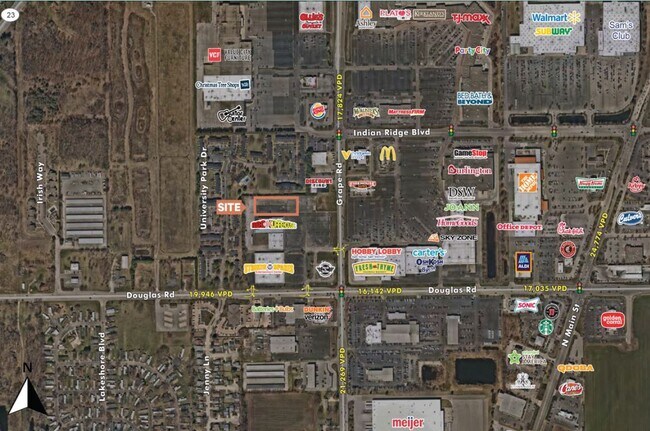
5603 Grape Rd, Mishawaka, IN 46545
This Property Is For Sale
Property Detail
5603 Grape Rd
South Bend-Mishawaka, IN-MI
LOT 5 GW GRAPE ROAD MINOR 23/24 NP #864 5/2/2022
71-04-28-376-010.000-005
St Joseph
Servicestation
Indiana
B and X Area of moderate flood hazard, usually the area between the limits of the 100-year and 500-year floods.
5
2024
0.85 AC
2025
Mishawaka
011506
South Bend/Mishawaka
4,352 SF
NEARBY LISTINGS FOR SALE OR LEASE
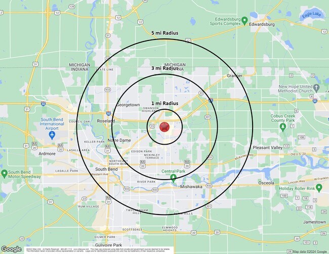
DEMOGRAPHICS near 5603 Grape Rd
1 mile
3 mile
5 mile
2025 Total Population
5,288
67,868
164,096
2030 Population
5,294
68,570
166,601
Pop Growth 2025-2030
+ 0.11%
+ 1.03%
+ 1.53%
Average Age
38
38
38
2025 Total Households
2,811
27,136
65,265
HH Growth 2025-2030
(0.11%)
+ 1.07%
+ 1.71%
Median Household Inc
$45,053
$65,764
$64,328
Avg Household Size
1.80
2.20
2.30
2025 Avg HH Vehicles
1.00
2.00
2.00
Median Home Value
$199,712
$216,996
$192,433
Median Year Built
1983
1977
1969
Nearby Places
Map Layers
Map Styles
 Street
 Aerial
Layers
 Traffic
 Biking
Places
Listings with unknown addresses are not visible on the map
- Restaurants
- Banks
- Shops
- Fitness
- Groceries
PUBLIC TRANSPORTATION
COMMUTER RAIL
Drive
Walk
Distance
16 min
6.7 mi
South Bend Airport Station (South Shore Line - Northern Indiana Commuter Transportation District (South Shore Line))
Drive
Walk
Distance
South Bend Airport Station (South Shore Line - Northern Indiana Commuter Transportation District (South Shore Line))
20 min
8.0 mi
AIRPORT
South Bend International
Drive
Walk
Distance
South Bend International
30 min
10.2 mi
Nearby Properties
Address
Land Use
TOTAL SIZE
Lot Size
Zoning
Address
Land Use
TOTAL SIZE
Lot Size
Zoning
1,089,534 SF
436.76 AC
Address
Land Use
TOTAL SIZE
Lot Size
Zoning
82,660 SF
48.07 AC
Address
Land Use
TOTAL SIZE
Lot Size
Zoning
266,075 SF
89.04 AC
Address
Land Use
TOTAL SIZE
Lot Size
Zoning
219,803 SF
59.79 AC
Address
Land Use
TOTAL SIZE
Lot Size
Zoning
39,988 SF
21.28 AC
Address
Land Use
TOTAL SIZE
Lot Size
Zoning
61,220 SF
19.80 AC
Address
Land Use
TOTAL SIZE
Lot Size
Zoning
162,985 SF
10.54 AC
Address
Land Use
TOTAL SIZE
Lot Size
Zoning
529,154 SF
30.30 AC
Address
Land Use
TOTAL SIZE
Lot Size
Zoning
41,528 SF
6.07 AC
Address
Land Use
TOTAL SIZE
Lot Size
Zoning
114,669 SF
13.81 AC
Address
Land Use
TOTAL SIZE
Lot Size
Zoning
41,917 SF
0.93 AC
Address
Land Use
TOTAL SIZE
Lot Size
Zoning
45,212 SF
Address
Land Use
TOTAL SIZE
Lot Size
Zoning
263,706 SF
4.60 AC
Address
Land Use
TOTAL SIZE
Lot Size
Zoning
10,000 SF
2.57 AC
Address
Land Use
TOTAL SIZE
Lot Size
Zoning
21,468 SF
1.66 AC
Address
Land Use
TOTAL SIZE
Lot Size
Zoning
55,106 SF
Address
Land Use
TOTAL SIZE
Lot Size
Zoning
416,191 SF
39.10 AC
Address
Land Use
TOTAL SIZE
Lot Size
Zoning
120,801 SF
30.51 AC
Address
Land Use
TOTAL SIZE
Lot Size
Zoning
27,043 SF
30.53 AC
Address
Land Use
TOTAL SIZE
Lot Size
Zoning
42,485 SF
1.68 AC
Address
Land Use
TOTAL SIZE
Lot Size
Zoning
38,938 SF
114.29 AC
Address
Land Use
TOTAL SIZE
Lot Size
Zoning
329,088 SF
47.27 AC
Address
Land Use
TOTAL SIZE
Lot Size
Zoning
51,570 SF
29.14 AC
Address
Land Use
TOTAL SIZE
Lot Size
Zoning
113,265 SF
2.33 AC
Address
Land Use
TOTAL SIZE
Lot Size
Zoning
133,277 SF
17.90 AC
Address
Land Use
TOTAL SIZE
Lot Size
Zoning
50,916 SF
11.52 AC
Address
Land Use
TOTAL SIZE
Lot Size
Zoning
385,405 SF
49.31 AC
Address
Land Use
TOTAL SIZE
Lot Size
Zoning
24,588 SF
20.82 AC
Address
Land Use
TOTAL SIZE
Lot Size
Zoning
37,589 SF
11.57 AC
Address
Land Use
TOTAL SIZE
Lot Size
Zoning
38,431 SF
1.58 AC
The World's #1 Commercial Real Estate Marketplace
Connect with us
© 2026 CoStar Group
The information above has been obtained from sources believed reliable. While we do not doubt its accuracy we have not verified it and make no guarantee, warranty or representation about it. It is your responsibility to independently confirm its accuracy and completeness. Any projections, opinions, assumptions, or estimates used are for example only and do not represent the current or future performance of the property. The value of this transaction to you depends on tax and other factors which should be evaluated by your tax, financial, and legal advisors. You and your advisors should conduct a careful, independent investigation of the property to determine to your satisfaction the suitability of the property for your needs.