Property Record
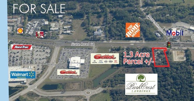
5603 Sr 64 Rd E, Bradenton, FL 34208

Property Detail
5603 Sr 64 Rd E
11127-0000-8
PARCEL 107: LOTS 9 THROUGH 14 INCLUSIVE, LOTS 20 THROUGH 25 INCLUSIVE AND REMAINING PORTIONS OF LOTS 15 THROUGH 19 INCLUSIVE LYING NLY OF N EXISTING R/W LN OF SR 64 (PER SEC
Stateproperty
MANATEE
NC-M NBRHD
Florida
AE The base floodplain where base flood elevations are provided. AE Zones are now used on new format FIRMs instead of A1-A30 Zones.
9
0
2.16 AC
2025
Manatee
000705
Tampa/St Petersburg
1,056 SF
North Port-Bradenton-Sarasota, FL
NEARBY LISTINGS FOR SALE OR LEASE
DEMOGRAPHICS near 5603 Sr 64 Rd E
1 mile
3 mile
5 mile
2025 Total Population
7,156
41,187
146,042
2030 Population
8,053
46,124
163,809
Pop Growth 2025-2030
+ 12.53%
+ 11.99%
+ 12.17%
Average Age
41
47
46
2025 Total Households
3,128
17,830
59,914
HH Growth 2025-2030
+ 12.63%
+ 12.18%
+ 12.50%
Median Household Inc
$74,804
$81,815
$80,045
Avg Household Size
2.30
2.30
2.40
2025 Avg HH Vehicles
2.00
2.00
2.00
Median Home Value
$374,844
$427,796
$409,933
Median Year Built
2006
1999
2000
Nearby Places
Map Layers
Map Styles
 Street
 Aerial
Transit
 Traffic
 Biking
Places
Listings with unknown addresses are not visible on the map
- Restaurants
- Banks
- Shops
- Fitness
- Groceries
PUBLIC TRANSPORTATION
AIRPORT
Sarasota/Bradenton International
Drive
Walk
Distance
Sarasota/Bradenton International
27 min
16.8 mi
Freight Ports
Port Manatee
Drive
Walk
Distance
Port Manatee
25 min
15.1 mi
SALE & LEASE HISTORY
LISTING DATE
SALE/LEASE

Sep 24, 2016
For Sale
Nearby Properties
Address
Land Use
TOTAL SIZE
Lot Size
Zoning
Address
Land Use
TOTAL SIZE
Lot Size
Zoning
622,266 SF
68.76 AC
PD-MU
Address
Land Use
TOTAL SIZE
Lot Size
Zoning
881,490 SF
83.09 AC
BR_R-3
Address
Land Use
TOTAL SIZE
Lot Size
Zoning
513,465 SF
78.39 AC
PD-MU
Address
Land Use
TOTAL SIZE
Lot Size
Zoning
707,409 SF
27.98 AC
PD-MU
Address
Land Use
TOTAL SIZE
Lot Size
Zoning
319,679 SF
31.78 AC
BR_R-1
Address
Land Use
TOTAL SIZE
Lot Size
Zoning
311,669 SF
34.55 AC
BR_R-2
Address
Land Use
TOTAL SIZE
Lot Size
Zoning
293,332 SF
50.52 AC
A-1 SUBURB
Address
Land Use
TOTAL SIZE
Lot Size
Zoning
225,768 SF
18.47 AC
BR_R-1
Address
Land Use
TOTAL SIZE
Lot Size
Zoning
270,900 SF
44.35 AC
PD-MU
Address
Land Use
TOTAL SIZE
Lot Size
Zoning
89,137 SF
11.61 AC
Address
Land Use
TOTAL SIZE
Lot Size
Zoning
348,901 SF
27 AC
BR_R-2
Address
Land Use
TOTAL SIZE
Lot Size
Zoning
191,100 SF
30.35 AC
PD-C
Address
Land Use
TOTAL SIZE
Lot Size
Zoning
160,163 SF
16.35 AC
PD-MU
Address
Land Use
TOTAL SIZE
Lot Size
Zoning
107,298 SF
12.91 AC
PD-MU
Address
Land Use
TOTAL SIZE
Lot Size
Zoning
220,706 SF
24.13 AC
PD-C, A-1
Address
Land Use
TOTAL SIZE
Lot Size
Zoning
234,818 SF
18.20 AC
BR_R-2
Address
Land Use
TOTAL SIZE
Lot Size
Zoning
201,982 SF
16.65 AC
BR_SCC
Address
Land Use
TOTAL SIZE
Lot Size
Zoning
13,621 SF
61.72 AC
PD-RV,RSF-
Address
Land Use
TOTAL SIZE
Lot Size
Zoning
92,466 SF
18.80 AC
A-1 SUBURB
Address
Land Use
TOTAL SIZE
Lot Size
Zoning
89,912 SF
5.05 AC
Address
Land Use
TOTAL SIZE
Lot Size
Zoning
61,770 SF
79.85 AC
A,A-1
Address
Land Use
TOTAL SIZE
Lot Size
Zoning
151,596 SF
29.79 AC
BR_PDP
Address
Land Use
TOTAL SIZE
Lot Size
Zoning
138,535 SF
13.94 AC
BR_SCC
Address
Land Use
TOTAL SIZE
Lot Size
Zoning
91,918 SF
6.03 AC
PD-C
Address
Land Use
TOTAL SIZE
Lot Size
Zoning
69,192 SF
3.71 AC
Address
Land Use
TOTAL SIZE
Lot Size
Zoning
42,905 SF
6.17 AC
PD-C
Address
Land Use
TOTAL SIZE
Lot Size
Zoning
63,563 SF
4.44 AC
Address
Land Use
TOTAL SIZE
Lot Size
Zoning
59,222 SF
4.49 AC
PD-C
Address
Land Use
TOTAL SIZE
Lot Size
Zoning
65,761 SF
11.91 AC
BR_SCC
Address
Land Use
TOTAL SIZE
Lot Size
Zoning
47,241 SF
15.63 AC
A-1 SUBURB
The World's #1 Commercial Real Estate Marketplace
Connect with us
© 2026 CoStar Group
The information above has been obtained from sources believed reliable. While we do not doubt its accuracy we have not verified it and make no guarantee, warranty or representation about it. It is your responsibility to independently confirm its accuracy and completeness. Any projections, opinions, assumptions, or estimates used are for example only and do not represent the current or future performance of the property. The value of this transaction to you depends on tax and other factors which should be evaluated by your tax, financial, and legal advisors. You and your advisors should conduct a careful, independent investigation of the property to determine to your satisfaction the suitability of the property for your needs.