Property Record
5605 Avenida Del Mare, Sarasota, FL 34242

NEARBY LISTINGS FOR SALE OR LEASE
-
-
View all Sarasota listings for sale on LoopNet.com
Property Detail
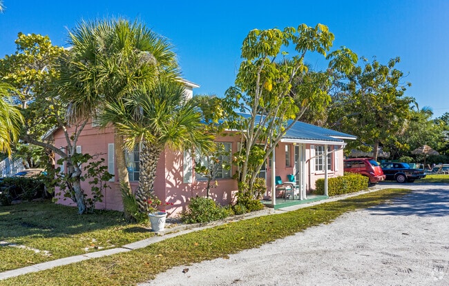
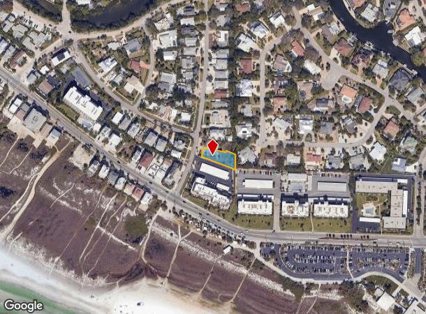
5605 Avenida Del Mare
North Port-Sarasota-Bradenton, FL
Sarasota Beach
0107-03-0012
BEG AT SE COR OF LOT 16 TH ALG ELY LINE OF LOT 16 ON AN ASSUMED N BEARING 64.91 FT TH CONT ON SAID BEARING & ALG ELY LINE OF SAID LOT 10.39 FT TH N-78-19-00- W 48.65 FT TH S-12-57-00-W 6.6 FT TH
Residentialacreage
Sarasota
AE
Florida
12115C0143G
16
2024
0.24 AC
2025
Sarasota/Beaches
001904
Tampa/St Petersburg
1,911 SF
DEMOGRAPHICS near 5605 Avenida Del Mare
1 Mile
3 Mile
5 Mile
2024 Total Population
6,594
35,304
96,318
2029 Population
8,085
41,798
112,032
Pop Growth 2024-2029
+ 22.61%
+ 18.39%
+ 16.31%
Average Age
59
54
52
2024 Total Households
3,369
17,454
46,926
HH Growth 2024-2029
+ 22.89%
+ 18.67%
+ 16.57%
Median Household Inc
$108,321
$86,893
$77,078
Avg Household Size
1.90
2.00
2.00
2024 Avg HH Vehicles
2.00
2.00
2.00
Median Home Value
$777,842
$571,239
$424,248
Median Year Built
1975
1975
1975
Nearby Places
Map Layers
Map Styles
 Street
 Aerial
- Restaurants
- Banks
- Shops
- Fitness
- Groceries
PUBLIC TRANSPORTATION
AIRPORT
Sarasota/Bradenton International
DRIVE
WALK
Distance
Sarasota/Bradenton International
25 min
11.5 mi
Freight Ports
Port Manatee
DRIVE
WALK
Distance
Port Manatee
52 min
36.6 mi
Nearby Properties
Address
Land Use
TOTAL SIZE
Lot Size
Zoning
Address
Land Use
TOTAL SIZE
Lot Size
Zoning
588,839 SF
42.33 AC
GU
Address
Land Use
TOTAL SIZE
Lot Size
Zoning
11,781 SF
43.95 AC
GU
Address
Land Use
TOTAL SIZE
Lot Size
Zoning
332,822 SF
34.74 AC
CG
Address
Land Use
TOTAL SIZE
Lot Size
Zoning
2,900 SF
152 AC
G
Address
Land Use
TOTAL SIZE
Lot Size
Zoning
133,389 SF
6.14 AC
WFR
Address
Land Use
TOTAL SIZE
Lot Size
Zoning
17,718 SF
3.91 AC
WFR
Address
Land Use
TOTAL SIZE
Lot Size
Zoning
151,814 SF
10.89 AC
CSCC
Address
Land Use
TOTAL SIZE
Lot Size
Zoning
133,430 SF
19.60 AC
GU
Address
Land Use
TOTAL SIZE
Lot Size
Zoning
146,339 SF
12.54 AC
CG
Address
Land Use
TOTAL SIZE
Lot Size
Zoning
177,957 SF
19.36 AC
G
Address
Land Use
TOTAL SIZE
Lot Size
Zoning
376,559 SF
26.52 AC
CSC
Address
Land Use
TOTAL SIZE
Lot Size
Zoning
96,425 SF
8.59 AC
OPI
Address
Land Use
TOTAL SIZE
Lot Size
Zoning
73,810 SF
3.98 AC
WFR
Address
Land Use
TOTAL SIZE
Lot Size
Zoning
139,974 SF
6.07 AC
RMF4
Address
Land Use
TOTAL SIZE
Lot Size
Zoning
89,101 SF
8.42 AC
CGD
Address
Land Use
TOTAL SIZE
Lot Size
Zoning
81,166 SF
13.18 AC
GU
Address
Land Use
TOTAL SIZE
Lot Size
Zoning
86,102 SF
5.23 AC
RMF3
Address
Land Use
TOTAL SIZE
Lot Size
Zoning
7,872 SF
1.63 AC
RSF1
Address
Land Use
TOTAL SIZE
Lot Size
Zoning
76,273 SF
6.53 AC
CSCC
Address
Land Use
TOTAL SIZE
Lot Size
Zoning
13,643 SF
36.64 AC
GU
Address
Land Use
TOTAL SIZE
Lot Size
Zoning
33,200 SF
16.91 AC
RSF1
Address
Land Use
TOTAL SIZE
Lot Size
Zoning
38,517 SF
7.56 AC
CI
Address
Land Use
TOTAL SIZE
Lot Size
Zoning
8,163 SF
2.40 AC
RMF4
Address
Land Use
TOTAL SIZE
Lot Size
Zoning
44,403 SF
20.98 AC
RSF3
Address
Land Use
TOTAL SIZE
Lot Size
Zoning
83,730 SF
1.53 AC
CG
Address
Land Use
TOTAL SIZE
Lot Size
Zoning
17,719 SF
6.47 AC
RMF2
Address
Land Use
TOTAL SIZE
Lot Size
Zoning
5,738 SF
10.38 AC
RMF1
Address
Land Use
TOTAL SIZE
Lot Size
Zoning
17,214 SF
1.85 AC
RSF1
Address
Land Use
TOTAL SIZE
Lot Size
Zoning
12,270 SF
0.87 AC
RSF1
Address
Land Use
TOTAL SIZE
Lot Size
Zoning
25.01 AC
CG
The World's #1 Commercial Real Estate Marketplace
Connect with us
© 2025 CoStar Group
The information above has been obtained from sources believed reliable. While we do not doubt its accuracy we have not verified it and make no guarantee, warranty or representation about it. It is your responsibility to independently confirm its accuracy and completeness. Any projections, opinions, assumptions, or estimates used are for example only and do not represent the current or future performance of the property. The value of this transaction to you depends on tax and other factors which should be evaluated by your tax, financial, and legal advisors. You and your advisors should conduct a careful, independent investigation of the property to determine to your satisfaction the suitability of the property for your needs.