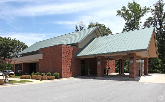
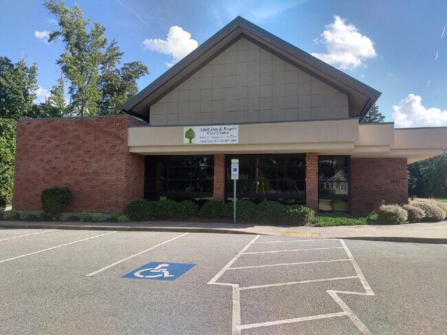
Property Record
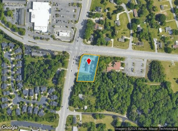
5605 Hilltop Rd, Jamestown, NC 27282
Current Lease Availabilities
NEARBY LISTINGS FOR SALE OR LEASE
Property Detail
5605 Hilltop Rd
Greensboro-High Point, NC
Unitarian Universalist
0155090
COMMUNITYONE BANK/JAMESTOWN PL:172-127
Officebuilding
Guilford
X
North Carolina
3710782300J
2
2024
1.18 AC
2025
Central Guilford County
016505
Greensboro/Winston-Salem
4,203 SF
DEMOGRAPHICS near 5605 Hilltop Rd
1 Mile
3 Mile
5 Mile
2024 Total Population
8,128
48,679
125,052
2029 Population
8,030
48,461
124,701
Pop Growth 2024-2029
(1.21%)
(0.45%)
(0.28%)
Average Age
39
40
39
2024 Total Households
3,580
21,990
54,299
HH Growth 2024-2029
(1.17%)
(0.42%)
(0.29%)
Median Household Inc
$84,578
$67,243
$61,828
Avg Household Size
2.20
2.20
2.20
2024 Avg HH Vehicles
2.00
2.00
2.00
Median Home Value
$278,805
$203,682
$207,500
Median Year Built
1994
1993
1989
Nearby Places
Map Layers
Map Styles
 Street
 Aerial
- Restaurants
- Banks
- Shops
- Fitness
- Groceries
PUBLIC TRANSPORTATION
COMMUTER RAIL
High Point Station (Piedmont - North Carolina by Train (NC Train))
DRIVE
WALK
Distance
High Point Station (Piedmont - North Carolina by Train (NC Train))
16 min
9.3 mi
Greensboro Station (Piedmont - North Carolina by Train (NC Train))
DRIVE
WALK
Distance
Greensboro Station (Piedmont - North Carolina by Train (NC Train))
16 min
9.8 mi
AIRPORT
Piedmont Triad International
DRIVE
WALK
Distance
Piedmont Triad International
15 min
6.5 mi
Nearby Properties
Address
Land Use
TOTAL SIZE
Lot Size
Zoning
Address
Land Use
TOTAL SIZE
Lot Size
Zoning
892,800 SF
51.53 AC
HI
Address
Land Use
TOTAL SIZE
Lot Size
Zoning
37,237 SF
334.45 AC
HI
Address
Land Use
TOTAL SIZE
Lot Size
Zoning
1,307,155 SF
60.56 AC
C-H
Address
Land Use
TOTAL SIZE
Lot Size
Zoning
256,051 SF
37.69 AC
LI
Address
Land Use
TOTAL SIZE
Lot Size
Zoning
412,635 SF
37.70 AC
RM-12
Address
Land Use
TOTAL SIZE
Lot Size
Zoning
275,782 SF
27.65 AC
RM-12
Address
Land Use
TOTAL SIZE
Lot Size
Zoning
341,210 SF
13.43 AC
PUD
Address
Land Use
TOTAL SIZE
Lot Size
Zoning
536,466 SF
46.90 AC
PUD
Address
Land Use
TOTAL SIZE
Lot Size
Zoning
691,408 SF
58.69 AC
LI
Address
Land Use
TOTAL SIZE
Lot Size
Zoning
279,853 SF
19.80 AC
RM-18
Address
Land Use
TOTAL SIZE
Lot Size
Zoning
552,314 SF
38.47 AC
PDR
Address
Land Use
TOTAL SIZE
Lot Size
Zoning
419,281 SF
25.12 AC
CIV
Address
Land Use
TOTAL SIZE
Lot Size
Zoning
138,843 SF
115.56 AC
CU-LI
Address
Land Use
TOTAL SIZE
Lot Size
Zoning
230,664 SF
13.69 AC
HI
Address
Land Use
TOTAL SIZE
Lot Size
Zoning
374,522 SF
56.55 AC
HI
Address
Land Use
TOTAL SIZE
Lot Size
Zoning
367,819 SF
32.88 AC
C-H
Address
Land Use
TOTAL SIZE
Lot Size
Zoning
245,192 SF
15.27 AC
RM-12
Address
Land Use
TOTAL SIZE
Lot Size
Zoning
312,732 SF
14.27 AC
RM-18
Address
Land Use
TOTAL SIZE
Lot Size
Zoning
400,000 SF
46.72 AC
LI
Address
Land Use
TOTAL SIZE
Lot Size
Zoning
354,454 SF
20.65 AC
RM-18
Address
Land Use
TOTAL SIZE
Lot Size
Zoning
683,263 SF
52.92 AC
HI
Address
Land Use
TOTAL SIZE
Lot Size
Zoning
291,895 SF
21.52 AC
RM-26
Address
Land Use
TOTAL SIZE
Lot Size
Zoning
228,994 SF
15.59 AC
PUD
Address
Land Use
TOTAL SIZE
Lot Size
Zoning
231,597 SF
8.46 AC
PD-R
Address
Land Use
TOTAL SIZE
Lot Size
Zoning
145,105 SF
20.12 AC
C-M
Address
Land Use
TOTAL SIZE
Lot Size
Zoning
234,173 SF
22.14 AC
RM-12
Address
Land Use
TOTAL SIZE
Lot Size
Zoning
256,423 SF
20.64 AC
PUD
Address
Land Use
TOTAL SIZE
Lot Size
Zoning
341,118 SF
36.48 AC
LI
Address
Land Use
TOTAL SIZE
Lot Size
Zoning
309,749 SF
16.74 AC
CZ-PDM
Address
Land Use
TOTAL SIZE
Lot Size
Zoning
274,999 SF
21.57 AC
LI
The World's #1 Commercial Real Estate Marketplace
Connect with us
© 2026 CoStar Group
The information above has been obtained from sources believed reliable. While we do not doubt its accuracy we have not verified it and make no guarantee, warranty or representation about it. It is your responsibility to independently confirm its accuracy and completeness. Any projections, opinions, assumptions, or estimates used are for example only and do not represent the current or future performance of the property. The value of this transaction to you depends on tax and other factors which should be evaluated by your tax, financial, and legal advisors. You and your advisors should conduct a careful, independent investigation of the property to determine to your satisfaction the suitability of the property for your needs.