Property Record
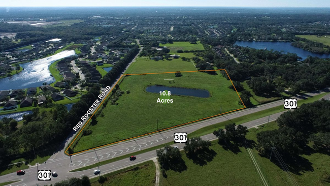
5605 Red Rooster Rd, Parrish, FL 34219


Property Detail
5605 Red Rooster Rd
4875-1075-2
COM AT SW COR OF SEC 32; TH N 00 DEG 08 MIN 00 SEC W ALG W LN OF SEC 32, 2109.90 FT FOR POB; TH N 08 DEG 37 MIN 25 SEC E, 552.52 FT TO SLY R/W LN OF U S HWY 301; TH N 60 DEG 05
Vacantlandnec
MANATEE
RSF-1
Florida
A Areas with a 1% annual chance of flooding and a 26% chance of flooding over the life of a 30-year mortgage.
10.80 AC
2023
Manatee
2025
Tampa/St Petersburg
001913
North Port-Bradenton-Sarasota, FL
NEARBY LISTINGS FOR SALE OR LEASE
DEMOGRAPHICS near 5605 Red Rooster Rd
1 mile
3 mile
5 mile
2025 Total Population
6,745
33,597
81,073
2030 Population
7,533
38,784
93,241
Pop Growth 2025-2030
+ 11.68%
+ 15.44%
+ 15.01%
Average Age
45
43
46
2025 Total Households
2,560
12,196
31,102
HH Growth 2025-2030
+ 11.88%
+ 14.99%
+ 14.61%
Median Household Inc
$91,853
$110,084
$104,839
Avg Household Size
2.60
2.70
2.50
2025 Avg HH Vehicles
2.00
2.00
2.00
Median Home Value
$396,307
$450,596
$455,546
Median Year Built
2008
2010
2010
Nearby Places
Map Layers
Map Styles
 Street
 Aerial
Layers
 Traffic
 Biking
Places
Listings with unknown addresses are not visible on the map
- Restaurants
- Banks
- Shops
- Fitness
- Groceries
PUBLIC TRANSPORTATION
AIRPORT
Sarasota/Bradenton International
Drive
Walk
Distance
Sarasota/Bradenton International
35 min
19.0 mi
St Pete-Clearwater International
Drive
Walk
Distance
St Pete-Clearwater International
59 min
41.5 mi
Tampa International
Drive
Walk
Distance
Tampa International
64 min
44.1 mi
Freight Ports
Port Manatee
Drive
Walk
Distance
Port Manatee
22 min
12.6 mi
SALE & LEASE HISTORY
LISTING DATE
SALE/LEASE

Sep 24, 2016
For Sale
Nov 30, 2021
For Sale
Nearby Properties
Address
Land Use
TOTAL SIZE
Lot Size
Zoning
Address
Land Use
TOTAL SIZE
Lot Size
Zoning
137.34 AC
Address
Land Use
TOTAL SIZE
Lot Size
Zoning
313,422 SF
47.93 AC
PD-C
Address
Land Use
TOTAL SIZE
Lot Size
Zoning
136.89 AC
Address
Land Use
TOTAL SIZE
Lot Size
Zoning
50.25 AC
Address
Land Use
TOTAL SIZE
Lot Size
Zoning
64,800 SF
8.19 AC
Address
Land Use
TOTAL SIZE
Lot Size
Zoning
66,063 SF
9.24 AC
PD-C
Address
Land Use
TOTAL SIZE
Lot Size
Zoning
43,464 SF
14.47 AC
VIL VILLAG
Address
Land Use
TOTAL SIZE
Lot Size
Zoning
190.90 AC
PD-R
Address
Land Use
TOTAL SIZE
Lot Size
Zoning
43.81 AC
Address
Land Use
TOTAL SIZE
Lot Size
Zoning
50,580 SF
5.97 AC
Address
Land Use
TOTAL SIZE
Lot Size
Zoning
61,721 SF
5.50 AC
PD-C
Address
Land Use
TOTAL SIZE
Lot Size
Zoning
61.03 AC
Address
Land Use
TOTAL SIZE
Lot Size
Zoning
28,413 SF
5.40 AC
RSMH-6
Address
Land Use
TOTAL SIZE
Lot Size
Zoning
53,851 SF
6.32 AC
Address
Land Use
TOTAL SIZE
Lot Size
Zoning
30,101 SF
13.44 AC
PD-C
Address
Land Use
TOTAL SIZE
Lot Size
Zoning
76.98 AC
Address
Land Use
TOTAL SIZE
Lot Size
Zoning
23,742 SF
5.21 AC
A-1 SUBURB
Address
Land Use
TOTAL SIZE
Lot Size
Zoning
36,700 SF
17 AC
A-1 SUBURB
Address
Land Use
TOTAL SIZE
Lot Size
Zoning
44,874 SF
394.53 AC
PD-PI
Address
Land Use
TOTAL SIZE
Lot Size
Zoning
109.06 AC
Address
Land Use
TOTAL SIZE
Lot Size
Zoning
25,912 SF
6.66 AC
PD-C
Address
Land Use
TOTAL SIZE
Lot Size
Zoning
3.11 AC
Address
Land Use
TOTAL SIZE
Lot Size
Zoning
4.07 AC
Address
Land Use
TOTAL SIZE
Lot Size
Zoning
53,448 SF
3 AC
PD-C
Address
Land Use
TOTAL SIZE
Lot Size
Zoning
44.29 AC
Address
Land Use
TOTAL SIZE
Lot Size
Zoning
25,842 SF
3.92 AC
Address
Land Use
TOTAL SIZE
Lot Size
Zoning
9,806 SF
4.04 AC
VIL VILLAG
Address
Land Use
TOTAL SIZE
Lot Size
Zoning
17,677 SF
9.52 AC
A-1 SUBURB
Address
Land Use
TOTAL SIZE
Lot Size
Zoning
113.80 AC
Address
Land Use
TOTAL SIZE
Lot Size
Zoning
13.62 AC
PD-R
The World's #1 Commercial Real Estate Marketplace
Connect with us
© 2026 CoStar Group
The information above has been obtained from sources believed reliable. While we do not doubt its accuracy we have not verified it and make no guarantee, warranty or representation about it. It is your responsibility to independently confirm its accuracy and completeness. Any projections, opinions, assumptions, or estimates used are for example only and do not represent the current or future performance of the property. The value of this transaction to you depends on tax and other factors which should be evaluated by your tax, financial, and legal advisors. You and your advisors should conduct a careful, independent investigation of the property to determine to your satisfaction the suitability of the property for your needs.