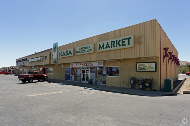
Property Record
56089 29 Palms Hwy, Yucca Valley, CA 92284
NEARBY LISTINGS FOR SALE OR LEASE
Property Detail
56089 29 Palms Hwy
0586-314-03
TRACT NO 2865 YUCCA VILLAGE LOTS 115 AND 116 EX ST
Commercialnec
San Bernardino
A
California
06065C0250G
115
2024
0.62 AC
2025
Twentynine Palms
010413
Inland Empire (California)
17,800 SF
Riverside-San Bernardino-Ontario, CA
DEMOGRAPHICS near 56089 29 Palms Hwy
1 Mile
3 Mile
5 Mile
2024 Total Population
5,451
18,825
24,973
2029 Population
5,625
19,399
25,761
Pop Growth 2024-2029
+ 3.19%
+ 3.05%
+ 3.16%
Average Age
42
43
42
2024 Total Households
2,437
7,820
10,179
HH Growth 2024-2029
+ 3.20%
+ 3.11%
+ 3.19%
Median Household Inc
$44,093
$61,577
$61,918
Avg Household Size
2.20
2.40
2.40
2024 Avg HH Vehicles
2.00
2.00
2.00
Median Home Value
$172,075
$294,673
$303,569
Median Year Built
1977
1979
1979
Nearby Places
Map Layers
Map Styles
 Street
 Aerial
- Restaurants
- Banks
- Shops
- Fitness
- Groceries
PUBLIC TRANSPORTATION
AIRPORT
Palm Springs International
DRIVE
WALK
Distance
Palm Springs International
41 min
30.1 mi
SALE & LEASE HISTORY
LISTING DATE
SALE/LEASE

May 01, 2017
For Sale
Mar 12, 2024
For Sale
Mar 07, 2022
For Sale
Nearby Properties
Address
Land Use
TOTAL SIZE
Lot Size
Zoning
Address
Land Use
TOTAL SIZE
Lot Size
Zoning
178,083 SF
1.75 AC
Address
Land Use
TOTAL SIZE
Lot Size
Zoning
51,455 SF
2.83 AC
Address
Land Use
TOTAL SIZE
Lot Size
Zoning
81,904 SF
2 AC
Address
Land Use
TOTAL SIZE
Lot Size
Zoning
104,442 SF
7.29 AC
Address
Land Use
TOTAL SIZE
Lot Size
Zoning
17,299 SF
1.74 AC
Address
Land Use
TOTAL SIZE
Lot Size
Zoning
45,139 SF
3.67 AC
Address
Land Use
TOTAL SIZE
Lot Size
Zoning
19,950 SF
1.57 AC
Address
Land Use
TOTAL SIZE
Lot Size
Zoning
41,321 SF
1.83 AC
Address
Land Use
TOTAL SIZE
Lot Size
Zoning
89,981 SF
8.08 AC
Address
Land Use
TOTAL SIZE
Lot Size
Zoning
25,193 SF
2.72 AC
Address
Land Use
TOTAL SIZE
Lot Size
Zoning
30,393 SF
3.83 AC
Address
Land Use
TOTAL SIZE
Lot Size
Zoning
20,485 SF
2.39 AC
Address
Land Use
TOTAL SIZE
Lot Size
Zoning
50,784 SF
11.37 AC
Address
Land Use
TOTAL SIZE
Lot Size
Zoning
10,399 SF
22.87 AC
Address
Land Use
TOTAL SIZE
Lot Size
Zoning
18,152 SF
5 AC
Address
Land Use
TOTAL SIZE
Lot Size
Zoning
14,285 SF
1.52 AC
Address
Land Use
TOTAL SIZE
Lot Size
Zoning
46,334 SF
2.20 AC
Address
Land Use
TOTAL SIZE
Lot Size
Zoning
17,422 SF
2.40 AC
Address
Land Use
TOTAL SIZE
Lot Size
Zoning
32,900 SF
4.18 AC
Address
Land Use
TOTAL SIZE
Lot Size
Zoning
40,000 SF
3.03 AC
Address
Land Use
TOTAL SIZE
Lot Size
Zoning
18,124 SF
1.07 AC
Address
Land Use
TOTAL SIZE
Lot Size
Zoning
49,282 SF
2.74 AC
Address
Land Use
TOTAL SIZE
Lot Size
Zoning
17,422 SF
2.36 AC
Address
Land Use
TOTAL SIZE
Lot Size
Zoning
22,981 SF
2.02 AC
Address
Land Use
TOTAL SIZE
Lot Size
Zoning
43,920 SF
4.38 AC
Address
Land Use
TOTAL SIZE
Lot Size
Zoning
4,264 SF
0.60 AC
Address
Land Use
TOTAL SIZE
Lot Size
Zoning
12,060 SF
4.92 AC
Address
Land Use
TOTAL SIZE
Lot Size
Zoning
13,000 SF
0.49 AC
Address
Land Use
TOTAL SIZE
Lot Size
Zoning
2,325 SF
0.74 AC
Address
Land Use
TOTAL SIZE
Lot Size
Zoning
48,946 SF
2.01 AC
The World's #1 Commercial Real Estate Marketplace
Connect with us
© 2026 CoStar Group
The information above has been obtained from sources believed reliable. While we do not doubt its accuracy we have not verified it and make no guarantee, warranty or representation about it. It is your responsibility to independently confirm its accuracy and completeness. Any projections, opinions, assumptions, or estimates used are for example only and do not represent the current or future performance of the property. The value of this transaction to you depends on tax and other factors which should be evaluated by your tax, financial, and legal advisors. You and your advisors should conduct a careful, independent investigation of the property to determine to your satisfaction the suitability of the property for your needs.