Property Record
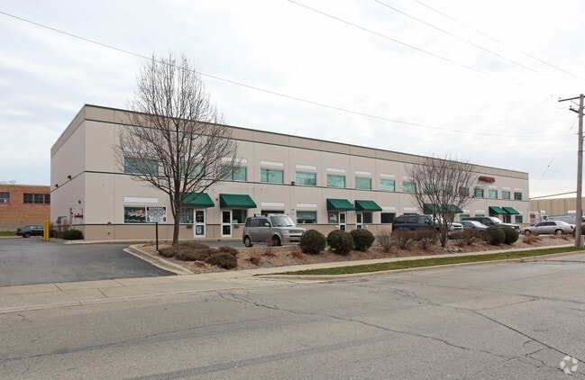
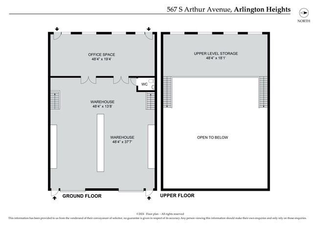
567 S Arthur Ave, Arlington Heights, IL 60005
Current Lease Availabilities
NEARBY LISTINGS FOR SALE OR LEASE
Property Detail
567 S Arthur Ave
03-33-300-084-1004
Gwn Indust Condo
Industrialcondominium
Cook
X
Illinois
17031C0204J
1
2023
1.12 AC
2024
Northwest Cook
803400
Chicago
1,745 SF
Chicago-Naperville-Elgin, IL-IN-WI
DEMOGRAPHICS near 567 S Arthur Ave
1 Mile
3 Mile
5 Mile
2024 Total Population
16,174
131,528
303,285
2029 Population
15,682
127,495
294,206
Pop Growth 2024-2029
(3.04%)
(3.07%)
(2.99%)
Average Age
42
42
42
2024 Total Households
6,268
51,491
119,696
HH Growth 2024-2029
(3.38%)
(3.42%)
(3.30%)
Median Household Inc
$115,561
$95,607
$88,658
Avg Household Size
2.50
2.50
2.50
2024 Avg HH Vehicles
2.00
2.00
2.00
Median Home Value
$392,364
$352,989
$325,564
Median Year Built
1963
1968
1971
Nearby Places
- Restaurants
- Banks
- Shops
- Fitness
- Groceries
PUBLIC TRANSPORTATION
COMMUTER RAIL
Arlington Heights Station (Union Pacific Northwest Line - Northeast Illinois Regional Commuter Railroad (Metra))
DRIVE
WALK
Distance
Arlington Heights Station (Union Pacific Northwest Line - Northeast Illinois Regional Commuter Railroad (Metra))
4 min
1.4 mi
Mount Prospect Station (Union Pacific Northwest Line - Northeast Illinois Regional Commuter Railroad (Metra))
DRIVE
WALK
Distance
Mount Prospect Station (Union Pacific Northwest Line - Northeast Illinois Regional Commuter Railroad (Metra))
4 min
2.1 mi
AIRPORT
Chicago O'Hare International
DRIVE
WALK
Distance
Chicago O'Hare International
19 min
11.0 mi
Chicago Midway International
DRIVE
WALK
Distance
Chicago Midway International
47 min
28.7 mi
Nearby Properties
Address
Land Use
TOTAL SIZE
Lot Size
Zoning
Address
Land Use
TOTAL SIZE
Lot Size
Zoning
32.56 AC
Address
Land Use
TOTAL SIZE
Lot Size
Zoning
6.53 AC
Address
Land Use
TOTAL SIZE
Lot Size
Zoning
Address
Land Use
TOTAL SIZE
Lot Size
Zoning
642,049 SF
33.14 AC
Address
Land Use
TOTAL SIZE
Lot Size
Zoning
366,052 SF
32.18 AC
Address
Land Use
TOTAL SIZE
Lot Size
Zoning
234,337 SF
23.59 AC
Address
Land Use
TOTAL SIZE
Lot Size
Zoning
18.34 AC
Address
Land Use
TOTAL SIZE
Lot Size
Zoning
255,638 SF
9.69 AC
Address
Land Use
TOTAL SIZE
Lot Size
Zoning
262,533 SF
32.21 AC
Address
Land Use
TOTAL SIZE
Lot Size
Zoning
Address
Land Use
TOTAL SIZE
Lot Size
Zoning
303,701 SF
31.18 AC
Address
Land Use
TOTAL SIZE
Lot Size
Zoning
211,275 SF
21.67 AC
Address
Land Use
TOTAL SIZE
Lot Size
Zoning
195,269 SF
11.07 AC
Address
Land Use
TOTAL SIZE
Lot Size
Zoning
283,822 SF
9.56 AC
Address
Land Use
TOTAL SIZE
Lot Size
Zoning
Address
Land Use
TOTAL SIZE
Lot Size
Zoning
304,912 SF
16.63 AC
Address
Land Use
TOTAL SIZE
Lot Size
Zoning
161,035 SF
13.57 AC
Address
Land Use
TOTAL SIZE
Lot Size
Zoning
286,720 SF
9.77 AC
Address
Land Use
TOTAL SIZE
Lot Size
Zoning
143,002 SF
14.58 AC
Address
Land Use
TOTAL SIZE
Lot Size
Zoning
130,791 SF
8.41 AC
Address
Land Use
TOTAL SIZE
Lot Size
Zoning
138,926 SF
2.81 AC
Address
Land Use
TOTAL SIZE
Lot Size
Zoning
397,654 SF
19.35 AC
Address
Land Use
TOTAL SIZE
Lot Size
Zoning
Address
Land Use
TOTAL SIZE
Lot Size
Zoning
176,325 SF
18.20 AC
Address
Land Use
TOTAL SIZE
Lot Size
Zoning
17.21 AC
Address
Land Use
TOTAL SIZE
Lot Size
Zoning
152,773 SF
1.30 AC
Address
Land Use
TOTAL SIZE
Lot Size
Zoning
Address
Land Use
TOTAL SIZE
Lot Size
Zoning
332,283 SF
Address
Land Use
TOTAL SIZE
Lot Size
Zoning
51,028 SF
4.20 AC
Address
Land Use
TOTAL SIZE
Lot Size
Zoning
312,281 SF
11.66 AC
The World's #1 Commercial Real Estate Marketplace
Connect with us
© 2025 CoStar Group
The information above has been obtained from sources believed reliable. While we do not doubt its accuracy we have not verified it and make no guarantee, warranty or representation about it. It is your responsibility to independently confirm its accuracy and completeness. Any projections, opinions, assumptions, or estimates used are for example only and do not represent the current or future performance of the property. The value of this transaction to you depends on tax and other factors which should be evaluated by your tax, financial, and legal advisors. You and your advisors should conduct a careful, independent investigation of the property to determine to your satisfaction the suitability of the property for your needs.