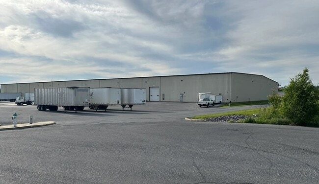
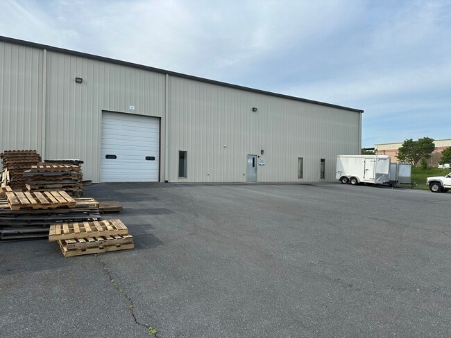
Property Record
561 Belle Cir, Harrisonburg, VA 22801

Current Lease Availabilities
Property Detail
561 Belle Cir
124F-2-L9
BLACK'S RUN INDUSTRIAL PARK S2 L 9
Warehouse
ROCKINGHAM
I1
Virginia
B and X Area of moderate flood hazard, usually the area between the limits of the 100-year and 500-year floods.
9
2025
6 AC
2025
Staunton & Harrisonburg
000207
Other Market Areas
80,000 SF
Harrisonburg, VA
NEARBY LISTINGS FOR SALE OR LEASE
DEMOGRAPHICS near 561 Belle Cir
1 mile
3 mile
5 mile
2025 Total Population
270
12,289
59,259
2030 Population
282
12,760
60,513
Pop Growth 2025-2030
+ 4.44%
+ 3.83%
+ 2.12%
Average Age
39
37
35
2025 Total Households
103
4,476
19,814
HH Growth 2025-2030
+ 3.88%
+ 3.95%
+ 2.44%
Median Household Inc
$84,615
$78,199
$74,371
Avg Household Size
2.60
2.50
2.50
2025 Avg HH Vehicles
2.00
2.00
2.00
Median Home Value
$376,666
$385,528
$370,045
Median Year Built
1997
1995
1994
Nearby Places
Map Layers
Map Styles
 Street
 Aerial
Layers
 Traffic
 Biking
Places
Listings with unknown addresses are not visible on the map
- Restaurants
- Banks
- Shops
- Fitness
- Groceries
PUBLIC TRANSPORTATION
AIRPORT
Charlottesville-Albemarle
Drive
Walk
Distance
Charlottesville-Albemarle
75 min
49.4 mi
Nearby Properties
Address
Land Use
TOTAL SIZE
Lot Size
Zoning
Address
Land Use
TOTAL SIZE
Lot Size
Zoning
126,552 SF
49.87 AC
GENERAL BU
Address
Land Use
TOTAL SIZE
Lot Size
Zoning
57.92 AC
I1
Address
Land Use
TOTAL SIZE
Lot Size
Zoning
199.08 AC
I1
Address
Land Use
TOTAL SIZE
Lot Size
Zoning
11.56 AC
B1
Address
Land Use
TOTAL SIZE
Lot Size
Zoning
260,792 SF
27.98 AC
P1
Address
Land Use
TOTAL SIZE
Lot Size
Zoning
225,359 SF
33.32 AC
I1
Address
Land Use
TOTAL SIZE
Lot Size
Zoning
11.11 AC
R3
Address
Land Use
TOTAL SIZE
Lot Size
Zoning
7,463 SF
74.63 AC
I1
Address
Land Use
TOTAL SIZE
Lot Size
Zoning
130,426 SF
19.11 AC
R1
Address
Land Use
TOTAL SIZE
Lot Size
Zoning
16.52 AC
TOWN
Address
Land Use
TOTAL SIZE
Lot Size
Zoning
295,543 SF
33.23 AC
I1
Address
Land Use
TOTAL SIZE
Lot Size
Zoning
905,215 SF
26.54 AC
M1
Address
Land Use
TOTAL SIZE
Lot Size
Zoning
13,578 SF
180 AC
HIGH DENSI
Address
Land Use
TOTAL SIZE
Lot Size
Zoning
2,129 SF
17.70 AC
R3
Address
Land Use
TOTAL SIZE
Lot Size
Zoning
84,000 SF
17 AC
GENERAL IN
Address
Land Use
TOTAL SIZE
Lot Size
Zoning
348,800 SF
26.90 AC
I1
Address
Land Use
TOTAL SIZE
Lot Size
Zoning
172,194 SF
4.24 AC
B1
Address
Land Use
TOTAL SIZE
Lot Size
Zoning
21.42 AC
I1
Address
Land Use
TOTAL SIZE
Lot Size
Zoning
4.82 AC
B1
Address
Land Use
TOTAL SIZE
Lot Size
Zoning
15.50 AC
GENERAL IN
Address
Land Use
TOTAL SIZE
Lot Size
Zoning
74,032 SF
20.64 AC
R3
Address
Land Use
TOTAL SIZE
Lot Size
Zoning
216,800 SF
19.20 AC
I1
Address
Land Use
TOTAL SIZE
Lot Size
Zoning
116,958 SF
9.85 AC
GENERAL BU
Address
Land Use
TOTAL SIZE
Lot Size
Zoning
36,612 SF
12.78 AC
R3
Address
Land Use
TOTAL SIZE
Lot Size
Zoning
47,160 SF
5.94 AC
GENERAL IN
Address
Land Use
TOTAL SIZE
Lot Size
Zoning
54,680 SF
16.64 AC
GENERAL BU
Address
Land Use
TOTAL SIZE
Lot Size
Zoning
44,350 SF
10 AC
GENERAL IN
Address
Land Use
TOTAL SIZE
Lot Size
Zoning
28,160 SF
2.57 AC
GENERAL BU
Address
Land Use
TOTAL SIZE
Lot Size
Zoning
552 SF
63.72 AC
MH1
Address
Land Use
TOTAL SIZE
Lot Size
Zoning
57,080 SF
1.98 AC
GENERAL BU
The World's #1 Commercial Real Estate Marketplace
Connect with us
© 2026 CoStar Group
The information above has been obtained from sources believed reliable. While we do not doubt its accuracy we have not verified it and make no guarantee, warranty or representation about it. It is your responsibility to independently confirm its accuracy and completeness. Any projections, opinions, assumptions, or estimates used are for example only and do not represent the current or future performance of the property. The value of this transaction to you depends on tax and other factors which should be evaluated by your tax, financial, and legal advisors. You and your advisors should conduct a careful, independent investigation of the property to determine to your satisfaction the suitability of the property for your needs.