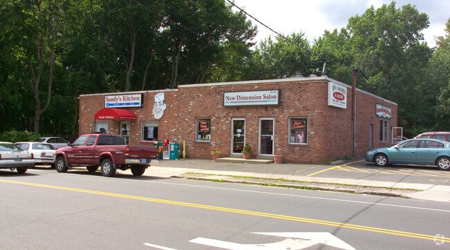
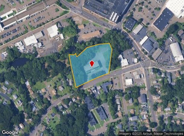
Property Record
561 Main St, West Haven, CT 06516
NEARBY LISTINGS FOR SALE OR LEASE
Property Detail
561 Main St
Publicschool
New Haven
AE
Connecticut
09009C0439J
3.83 AC
2025
West Haven
2025
Westchester/So Connecticut
154600
New Haven, CT
24,779 SF
WHAV-000034-000053
DEMOGRAPHICS near 561 Main St
1 Mile
3 Mile
5 Mile
2024 Total Population
19,663
81,579
215,666
2029 Population
19,175
80,726
213,505
Pop Growth 2024-2029
(2.48%)
(1.05%)
(1.00%)
Average Age
40
39
38
2024 Total Households
8,086
31,977
83,691
HH Growth 2024-2029
(2.55%)
(0.94%)
(0.99%)
Median Household Inc
$61,828
$61,409
$62,980
Avg Household Size
2.30
2.30
2.30
2024 Avg HH Vehicles
2.00
1.00
1.00
Median Home Value
$208,800
$233,261
$265,394
Median Year Built
1959
1959
1956
Nearby Places
Map Layers
Map Styles
 Street
 Aerial
- Restaurants
- Banks
- Shops
- Fitness
- Groceries
PUBLIC TRANSPORTATION
COMMUTER RAIL
DRIVE
WALK
Distance
1 min
10 min
0.5 mi
DRIVE
WALK
Distance
6 min
2.9 mi
AIRPORT
Tweed/New Haven
DRIVE
WALK
Distance
Tweed/New Haven
16 min
7.9 mi
Freight Ports
Port of New Haven
DRIVE
WALK
Distance
Port of New Haven
11 min
5.1 mi
Nearby Properties
Address
Land Use
TOTAL SIZE
Lot Size
Zoning
Address
Land Use
TOTAL SIZE
Lot Size
Zoning
289,886 SF
2.21 AC
BD2
Address
Land Use
TOTAL SIZE
Lot Size
Zoning
56,359 SF
17.09 AC
RCPD
Address
Land Use
TOTAL SIZE
Lot Size
Zoning
50.14 AC
PRD
Address
Land Use
TOTAL SIZE
Lot Size
Zoning
81,870 SF
3.86 AC
RM2
Address
Land Use
TOTAL SIZE
Lot Size
Zoning
302,262 SF
10.40 AC
RM1
Address
Land Use
TOTAL SIZE
Lot Size
Zoning
133,767 SF
1.25 AC
BD2
Address
Land Use
TOTAL SIZE
Lot Size
Zoning
486,703 SF
2.12 AC
BD
Address
Land Use
TOTAL SIZE
Lot Size
Zoning
72,708 SF
1.91 AC
PDU 87
Address
Land Use
TOTAL SIZE
Lot Size
Zoning
117,902 SF
1.41 AC
BD
Address
Land Use
TOTAL SIZE
Lot Size
Zoning
42.52 AC
PF
Address
Land Use
TOTAL SIZE
Lot Size
Zoning
287,844 SF
2.11 AC
IL
Address
Land Use
TOTAL SIZE
Lot Size
Zoning
158,622 SF
2.09 AC
BA/RM2
Address
Land Use
TOTAL SIZE
Lot Size
Zoning
29.78 AC
PRD
Address
Land Use
TOTAL SIZE
Lot Size
Zoning
76,945 SF
8.52 AC
RM2
Address
Land Use
TOTAL SIZE
Lot Size
Zoning
35.05 AC
LI-2
Address
Land Use
TOTAL SIZE
Lot Size
Zoning
205,756 SF
1.27 AC
PDD 15
Address
Land Use
TOTAL SIZE
Lot Size
Zoning
840,277 SF
4.28 AC
BD2
Address
Land Use
TOTAL SIZE
Lot Size
Zoning
119,187 SF
1.38 AC
RO
Address
Land Use
TOTAL SIZE
Lot Size
Zoning
214,516 SF
35.88 AC
RA
Address
Land Use
TOTAL SIZE
Lot Size
Zoning
54,372 SF
2.42 AC
BD2
Address
Land Use
TOTAL SIZE
Lot Size
Zoning
287.63 AC
OS
Address
Land Use
TOTAL SIZE
Lot Size
Zoning
125,676 SF
22.12 AC
BOP
Address
Land Use
TOTAL SIZE
Lot Size
Zoning
194,140 SF
1.50 AC
BD3
Address
Land Use
TOTAL SIZE
Lot Size
Zoning
85,592 SF
1.75 AC
BD1
Address
Land Use
TOTAL SIZE
Lot Size
Zoning
228,347 SF
0.66 AC
BA
Address
Land Use
TOTAL SIZE
Lot Size
Zoning
253,181 SF
1.86 AC
RH2
Address
Land Use
TOTAL SIZE
Lot Size
Zoning
155,143 SF
1.11 AC
BD
Address
Land Use
TOTAL SIZE
Lot Size
Zoning
297,601 SF
16.70 AC
PDD 10
Address
Land Use
TOTAL SIZE
Lot Size
Zoning
195,941 SF
1.15 AC
BD1
Address
Land Use
TOTAL SIZE
Lot Size
Zoning
56,509 SF
1.07 AC
BA
The World's #1 Commercial Real Estate Marketplace
Connect with us
© 2026 CoStar Group
The information above has been obtained from sources believed reliable. While we do not doubt its accuracy we have not verified it and make no guarantee, warranty or representation about it. It is your responsibility to independently confirm its accuracy and completeness. Any projections, opinions, assumptions, or estimates used are for example only and do not represent the current or future performance of the property. The value of this transaction to you depends on tax and other factors which should be evaluated by your tax, financial, and legal advisors. You and your advisors should conduct a careful, independent investigation of the property to determine to your satisfaction the suitability of the property for your needs.