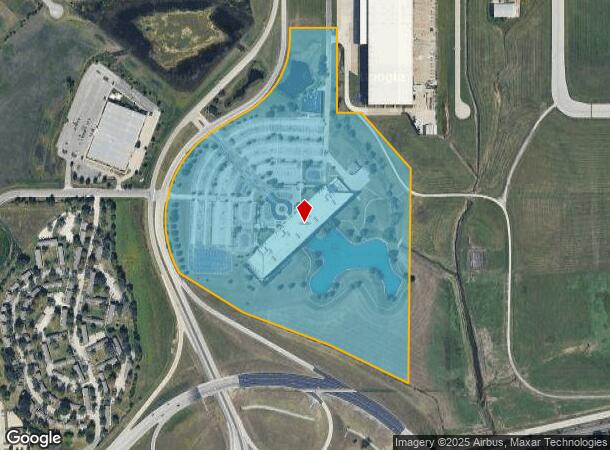
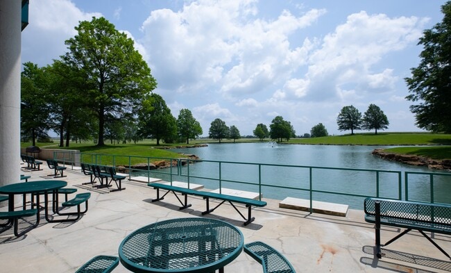
Property Record
561 Sumner Way St, New Century, KS 66031
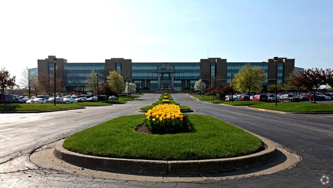
This Property Is For Sale
Current Lease Availabilities
NEARBY LISTINGS FOR SALE OR LEASE
Property Detail
561 Sumner Way St
2F231419-1005
19-14-23 BG 1750' S & 160' E NW CR NE1/4 E 410' S 460' SELY517.25' S 1308.61' NWLY 527.44' 570' & 457.39' N NWLY & NELY ALG CUR 1016.5' NELY 212.17' N & N ELY533.52' N 69.57' TO POB EX TR IN NE CR & EX .62 AC ( NEW CENTURY AIR CENTER ) ( NORTH SUPPLY
Officebuilding
Johnson
X
Kansas
20091C0106G
45.72 AC
0
South Johnson County
2024
Kansas City
053711
Kansas City, MO-KS
522,478 SF
DEMOGRAPHICS near 561 Sumner Way St
1 Mile
3 Mile
5 Mile
2024 Total Population
5,804
25,330
38,043
2029 Population
6,092
26,488
39,949
Pop Growth 2024-2029
+ 4.96%
+ 4.57%
+ 5.01%
Average Age
33
35
37
2024 Total Households
2,046
8,561
12,881
HH Growth 2024-2029
+ 5.13%
+ 4.84%
+ 5.24%
Median Household Inc
$72,489
$83,729
$90,116
Avg Household Size
2.80
2.80
2.80
2024 Avg HH Vehicles
2.00
2.00
2.00
Median Home Value
$233,914
$257,021
$288,118
Median Year Built
1996
1999
2001
Nearby Places
Map Layers
Map Styles
 Street
 Aerial
- Restaurants
- Banks
- Shops
- Fitness
- Groceries
PUBLIC TRANSPORTATION
AIRPORT
Kansas City International
DRIVE
WALK
Distance
Kansas City International
60 min
46.9 mi
Nearby Properties
Address
Land Use
TOTAL SIZE
Lot Size
Zoning
Address
Land Use
TOTAL SIZE
Lot Size
Zoning
287,502 SF
80.54 AC
PEC3
Address
Land Use
TOTAL SIZE
Lot Size
Zoning
345,346 SF
73.42 AC
R-1
Address
Land Use
TOTAL SIZE
Lot Size
Zoning
1,060,732 SF
57.62 AC
MP-2
Address
Land Use
TOTAL SIZE
Lot Size
Zoning
951,860 SF
55.73 AC
RUR
Address
Land Use
TOTAL SIZE
Lot Size
Zoning
71,086 SF
22.76 AC
R-3
Address
Land Use
TOTAL SIZE
Lot Size
Zoning
790,120 SF
38.55 AC
RUR
Address
Land Use
TOTAL SIZE
Lot Size
Zoning
750,100 SF
39.48 AC
RUR
Address
Land Use
TOTAL SIZE
Lot Size
Zoning
206,145 SF
55.77 AC
Address
Land Use
TOTAL SIZE
Lot Size
Zoning
1,005,940 SF
66.67 AC
L-P
Address
Land Use
TOTAL SIZE
Lot Size
Zoning
746,120 SF
PEC3
Address
Land Use
TOTAL SIZE
Lot Size
Zoning
648,070 SF
33.46 AC
MP-1
Address
Land Use
TOTAL SIZE
Lot Size
Zoning
569,960 SF
26.89 AC
M-2
Address
Land Use
TOTAL SIZE
Lot Size
Zoning
106,819 SF
14.43 AC
PEC3
Address
Land Use
TOTAL SIZE
Lot Size
Zoning
320,835 SF
57.95 AC
M-2
Address
Land Use
TOTAL SIZE
Lot Size
Zoning
565,272 SF
24.79 AC
RUR
Address
Land Use
TOTAL SIZE
Lot Size
Zoning
141,329 SF
20.88 AC
R-1
Address
Land Use
TOTAL SIZE
Lot Size
Zoning
1,107,600 SF
50.97 AC
MP-1
Address
Land Use
TOTAL SIZE
Lot Size
Zoning
73,451 SF
14.39 AC
R-1
Address
Land Use
TOTAL SIZE
Lot Size
Zoning
33,045 SF
15.25 AC
CP-2
Address
Land Use
TOTAL SIZE
Lot Size
Zoning
88,724 SF
127.92 AC
A
Address
Land Use
TOTAL SIZE
Lot Size
Zoning
189,334 SF
12.19 AC
PEC3
Address
Land Use
TOTAL SIZE
Lot Size
Zoning
73,451 SF
12.58 AC
A
Address
Land Use
TOTAL SIZE
Lot Size
Zoning
212,032 SF
9.53 AC
RUR
Address
Land Use
TOTAL SIZE
Lot Size
Zoning
331,712 SF
PEC3
Address
Land Use
TOTAL SIZE
Lot Size
Zoning
158.84 AC
RUR
Address
Land Use
TOTAL SIZE
Lot Size
Zoning
821,570 SF
44.78 AC
M-2
Address
Land Use
TOTAL SIZE
Lot Size
Zoning
88,250 SF
9.82 AC
PEC3
The World's #1 Commercial Real Estate Marketplace
Connect with us
© 2025 CoStar Group
The information above has been obtained from sources believed reliable. While we do not doubt its accuracy we have not verified it and make no guarantee, warranty or representation about it. It is your responsibility to independently confirm its accuracy and completeness. Any projections, opinions, assumptions, or estimates used are for example only and do not represent the current or future performance of the property. The value of this transaction to you depends on tax and other factors which should be evaluated by your tax, financial, and legal advisors. You and your advisors should conduct a careful, independent investigation of the property to determine to your satisfaction the suitability of the property for your needs.