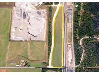
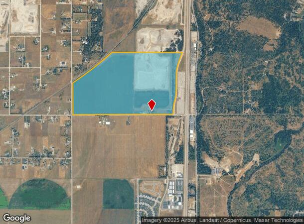
Property Record
561 W Boekel Rd, Rathdrum, ID 83858
NEARBY LISTINGS FOR SALE OR LEASE
Property Detail
561 W Boekel Rd
52N04W355300
S2 W OF HWY 95 & E OF RR RW EX PTN E OF CO RD 3552N04W
Multipleuses
Kootenai
X
Idaho
16055C0250E
238.32 AC
2025
Hayden/Dalton Gardens
2025
Coeur D'Alene
000201
Coeur d'Alene, ID
2,198 SF
DEMOGRAPHICS near 561 W Boekel Rd
1 Mile
3 Mile
5 Mile
2024 Total Population
383
13,397
47,656
2029 Population
454
15,887
56,701
Pop Growth 2024-2029
+ 18.54%
+ 18.59%
+ 18.98%
Average Age
42
43
42
2024 Total Households
140
5,004
17,945
HH Growth 2024-2029
+ 17.86%
+ 18.19%
+ 18.60%
Median Household Inc
$99,038
$81,104
$75,704
Avg Household Size
2.80
2.60
2.60
2024 Avg HH Vehicles
3.00
3.00
2.00
Median Home Value
$484,285
$514,092
$466,303
Median Year Built
1998
1993
1999
Nearby Places
Map Layers
Map Styles
 Street
 Aerial
- Restaurants
- Banks
- Shops
- Fitness
- Groceries
Nearby Properties
Address
Land Use
TOTAL SIZE
Lot Size
Zoning
Address
Land Use
TOTAL SIZE
Lot Size
Zoning
36,622 SF
60.16 AC
LTIND
Address
Land Use
TOTAL SIZE
Lot Size
Zoning
60,020 SF
9.52 AC
Address
Land Use
TOTAL SIZE
Lot Size
Zoning
87,176 SF
14.18 AC
Address
Land Use
TOTAL SIZE
Lot Size
Zoning
45,316 SF
5.79 AC
Address
Land Use
TOTAL SIZE
Lot Size
Zoning
46,560 SF
3.58 AC
Address
Land Use
TOTAL SIZE
Lot Size
Zoning
82,250 SF
8.76 AC
Address
Land Use
TOTAL SIZE
Lot Size
Zoning
67,220 SF
7.21 AC
Address
Land Use
TOTAL SIZE
Lot Size
Zoning
34,236 SF
9.48 AC
Address
Land Use
TOTAL SIZE
Lot Size
Zoning
58,000 SF
4.78 AC
Address
Land Use
TOTAL SIZE
Lot Size
Zoning
49,241 SF
2.81 AC
LTIND
Address
Land Use
TOTAL SIZE
Lot Size
Zoning
28,788 SF
9.38 AC
Address
Land Use
TOTAL SIZE
Lot Size
Zoning
50,532 SF
4.70 AC
AGSUB
Address
Land Use
TOTAL SIZE
Lot Size
Zoning
18,180 SF
3.94 AC
Address
Land Use
TOTAL SIZE
Lot Size
Zoning
48,040 SF
10 AC
LTIND
Address
Land Use
TOTAL SIZE
Lot Size
Zoning
19,600 SF
168.52 AC
LTIND
Address
Land Use
TOTAL SIZE
Lot Size
Zoning
47,845 SF
14.85 AC
Address
Land Use
TOTAL SIZE
Lot Size
Zoning
15,609 SF
35.15 AC
Address
Land Use
TOTAL SIZE
Lot Size
Zoning
720 SF
291.71 AC
AG
Address
Land Use
TOTAL SIZE
Lot Size
Zoning
35,340 SF
4.55 AC
Address
Land Use
TOTAL SIZE
Lot Size
Zoning
6,986 SF
54.55 AC
RESRES
Address
Land Use
TOTAL SIZE
Lot Size
Zoning
7,752 SF
5 AC
Address
Land Use
TOTAL SIZE
Lot Size
Zoning
13,760 SF
5.77 AC
Address
Land Use
TOTAL SIZE
Lot Size
Zoning
46,800 SF
17.49 AC
COM
Address
Land Use
TOTAL SIZE
Lot Size
Zoning
32,496 SF
4.38 AC
Address
Land Use
TOTAL SIZE
Lot Size
Zoning
30,350 SF
4.13 AC
LTIND
Address
Land Use
TOTAL SIZE
Lot Size
Zoning
38,400 SF
4.65 AC
AGSUB
Address
Land Use
TOTAL SIZE
Lot Size
Zoning
41,836 SF
13.06 AC
LTIND
Address
Land Use
TOTAL SIZE
Lot Size
Zoning
16,896 SF
3.66 AC
Address
Land Use
TOTAL SIZE
Lot Size
Zoning
17,707 SF
5.12 AC
COM
The World's #1 Commercial Real Estate Marketplace
Connect with us
© 2025 CoStar Group
The information above has been obtained from sources believed reliable. While we do not doubt its accuracy we have not verified it and make no guarantee, warranty or representation about it. It is your responsibility to independently confirm its accuracy and completeness. Any projections, opinions, assumptions, or estimates used are for example only and do not represent the current or future performance of the property. The value of this transaction to you depends on tax and other factors which should be evaluated by your tax, financial, and legal advisors. You and your advisors should conduct a careful, independent investigation of the property to determine to your satisfaction the suitability of the property for your needs.