Property Record
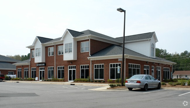
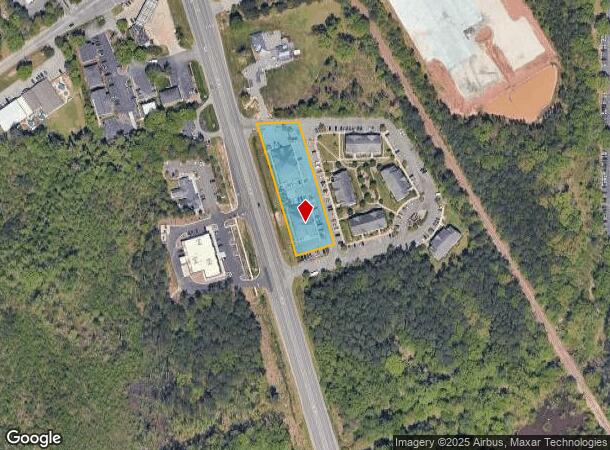
5521 Nc Highway 55, Durham, NC 27713

NEARBY LISTINGS FOR SALE OR LEASE
Property Detail
5521 Nc Highway 55
Durham-Chapel Hill, NC
Bentley Rdg Lot 1/L-1A
207244
BENTLEY RIDGE/LT#01-A DEB/SEE COMMENTS PL:000175-000336
Officebuilding
Durham
X
North Carolina
3720073700K
1
2025
1.22 AC
2025
Research Triangle
002022
Raleigh/Durham
19,264 SF
DEMOGRAPHICS near 5521 Nc Highway 55
1 Mile
3 Mile
5 Mile
2024 Total Population
3,710
41,884
133,396
2029 Population
3,881
43,978
142,492
Pop Growth 2024-2029
+ 4.61%
+ 5.00%
+ 6.82%
Average Age
39
37
37
2024 Total Households
1,622
18,566
55,589
HH Growth 2024-2029
+ 4.87%
+ 5.17%
+ 6.71%
Median Household Inc
$52,554
$90,119
$97,808
Avg Household Size
2.20
2.20
2.40
2024 Avg HH Vehicles
2.00
2.00
2.00
Median Home Value
$261,214
$333,360
$369,425
Median Year Built
1993
2003
2005
Nearby Places
Map Layers
Map Styles
 Street
 Aerial
- Restaurants
- Banks
- Shops
- Fitness
- Groceries
PUBLIC TRANSPORTATION
COMMUTER RAIL
DRIVE
WALK
Distance
16 min
8.7 mi
AIRPORT
Raleigh-Durham International
DRIVE
WALK
Distance
Raleigh-Durham International
16 min
9.4 mi
SALE & LEASE HISTORY
LISTING DATE
SALE/LEASE

Sep 25, 2016
For Lease
Nearby Properties
Address
Land Use
TOTAL SIZE
Lot Size
Zoning
Address
Land Use
TOTAL SIZE
Lot Size
Zoning
2,436,024 SF
SRP
Address
Land Use
TOTAL SIZE
Lot Size
Zoning
896,802 SF
86.14 AC
RA
Address
Land Use
TOTAL SIZE
Lot Size
Zoning
1,272,163 SF
117.61 AC
OI,SRP
Address
Land Use
TOTAL SIZE
Lot Size
Zoning
1,378,965 SF
183.46 AC
SRP
Address
Land Use
TOTAL SIZE
Lot Size
Zoning
868,283 SF
56.23 AC
SRP
Address
Land Use
TOTAL SIZE
Lot Size
Zoning
507,119 SF
118.85 AC
SRP
Address
Land Use
TOTAL SIZE
Lot Size
Zoning
799,818 SF
84.58 AC
IL
Address
Land Use
TOTAL SIZE
Lot Size
Zoning
168,660 SF
15.49 AC
CG(D)
Address
Land Use
TOTAL SIZE
Lot Size
Zoning
444,254 SF
58.71 AC
SRP
Address
Land Use
TOTAL SIZE
Lot Size
Zoning
122,544 SF
8.04 AC
MU(D)
Address
Land Use
TOTAL SIZE
Lot Size
Zoning
624,324 SF
81.65 AC
RA
Address
Land Use
TOTAL SIZE
Lot Size
Zoning
35.03 AC
RS-M(D)
Address
Land Use
TOTAL SIZE
Lot Size
Zoning
627,566 SF
37.83 AC
RA
Address
Land Use
TOTAL SIZE
Lot Size
Zoning
449,992 SF
25.16 AC
IP
Address
Land Use
TOTAL SIZE
Lot Size
Zoning
597,624 SF
53.04 AC
RA
Address
Land Use
TOTAL SIZE
Lot Size
Zoning
373,099 SF
14.08 AC
GCM
Address
Land Use
TOTAL SIZE
Lot Size
Zoning
47,376 SF
11.86 AC
OI(D)
Address
Land Use
TOTAL SIZE
Lot Size
Zoning
319,275 SF
50.52 AC
SRP
Address
Land Use
TOTAL SIZE
Lot Size
Zoning
353,339 SF
25.95 AC
SRP
Address
Land Use
TOTAL SIZE
Lot Size
Zoning
477,384 SF
37.07 AC
RMFM
Address
Land Use
TOTAL SIZE
Lot Size
Zoning
287,321 SF
12.68 AC
GCM
Address
Land Use
TOTAL SIZE
Lot Size
Zoning
2.82 AC
SRP-C
Address
Land Use
TOTAL SIZE
Lot Size
Zoning
23,889 SF
50.95 AC
OI
Address
Land Use
TOTAL SIZE
Lot Size
Zoning
7,080 SF
30.67 AC
OI,RS-M
Address
Land Use
TOTAL SIZE
Lot Size
Zoning
6,948 SF
21.22 AC
RS-M(D)
Address
Land Use
TOTAL SIZE
Lot Size
Zoning
292,739 SF
55.64 AC
GCM
Address
Land Use
TOTAL SIZE
Lot Size
Zoning
10,143 SF
46.78 AC
PDR 5.940
Address
Land Use
TOTAL SIZE
Lot Size
Zoning
7,241 SF
25.34 AC
PDR 5.370
Address
Land Use
TOTAL SIZE
Lot Size
Zoning
300,042 SF
41.03 AC
SRP
Address
Land Use
TOTAL SIZE
Lot Size
Zoning
295,946 SF
15.35 AC
RMFM
The World's #1 Commercial Real Estate Marketplace
Connect with us
© 2025 CoStar Group
The information above has been obtained from sources believed reliable. While we do not doubt its accuracy we have not verified it and make no guarantee, warranty or representation about it. It is your responsibility to independently confirm its accuracy and completeness. Any projections, opinions, assumptions, or estimates used are for example only and do not represent the current or future performance of the property. The value of this transaction to you depends on tax and other factors which should be evaluated by your tax, financial, and legal advisors. You and your advisors should conduct a careful, independent investigation of the property to determine to your satisfaction the suitability of the property for your needs.