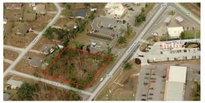
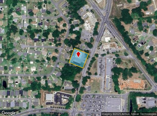
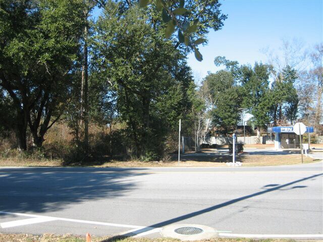
Property Record
5611 Woodbine Rd, Milton, FL 32571
NEARBY LISTINGS FOR SALE OR LEASE
-
-
View all Milton listings for sale on LoopNet.com
Property Detail
5611 Woodbine Rd
Pensacola-Ferry Pass-Brent, FL
Autumn Run North Phase 1
31-2N-29-0000-00105-0000
BEG AT SE CORN OF LOT 9 BLK B AUTUMN RUN NORTH PHS 1 TH N 21*1021 E 200.34 FT TO SW CORN OF OR 2123 PG 189 TH S 68 *5411 E 199.93 FT TO W R/W OF WOODBINE RD TH S 21*0834 W ALONG R/W 200.65 FT TO N R/W OF DOVE DR TH N 68*49 W ALON G R/W 200.04 FT TO P
Storebuilding
Santa Rosa
X
Florida
12113C0293H
9
2024
0.92 AC
2025
Gonzalez/SW Santa Rosa
010707
Pensacola
5,830 SF
DEMOGRAPHICS near 5611 Woodbine Rd
1 Mile
3 Mile
5 Mile
2024 Total Population
4,470
22,435
36,977
2029 Population
5,143
25,706
42,297
Pop Growth 2024-2029
+ 15.06%
+ 14.58%
+ 14.39%
Average Age
40
39
39
2024 Total Households
1,588
7,897
13,255
HH Growth 2024-2029
+ 15.24%
+ 14.83%
+ 14.67%
Median Household Inc
$92,975
$87,137
$82,930
Avg Household Size
2.80
2.80
2.80
2024 Avg HH Vehicles
2.00
2.00
2.00
Median Home Value
$324,329
$288,837
$273,503
Median Year Built
2001
2001
1999
Nearby Places
Map Layers
Map Styles
 Street
 Aerial
- Restaurants
- Banks
- Shops
- Fitness
- Groceries
PUBLIC TRANSPORTATION
AIRPORT
Pensacola International
DRIVE
WALK
Distance
Pensacola International
27 min
14.9 mi
SALE & LEASE HISTORY
LISTING DATE
SALE/LEASE

Sep 24, 2016
For Sale
Nov 06, 2018
For Sale
Aug 03, 2017
For Sale
Apr 05, 2017
For Sale
Nearby Properties
Address
Land Use
TOTAL SIZE
Lot Size
Zoning
Address
Land Use
TOTAL SIZE
Lot Size
Zoning
47.05 AC
AG-RR
Address
Land Use
TOTAL SIZE
Lot Size
Zoning
52,875 SF
5.24 AC
HCD
Address
Land Use
TOTAL SIZE
Lot Size
Zoning
51,329 SF
5.65 AC
HCD
Address
Land Use
TOTAL SIZE
Lot Size
Zoning
23.33 AC
AG-RR
Address
Land Use
TOTAL SIZE
Lot Size
Zoning
93,476 SF
7.43 AC
HCD
Address
Land Use
TOTAL SIZE
Lot Size
Zoning
94,231 SF
14.72 AC
HCD
Address
Land Use
TOTAL SIZE
Lot Size
Zoning
389.54 AC
AG-RR
Address
Land Use
TOTAL SIZE
Lot Size
Zoning
80,141 SF
11.33 AC
HCD
Address
Land Use
TOTAL SIZE
Lot Size
Zoning
602.07 AC
AG-RR
Address
Land Use
TOTAL SIZE
Lot Size
Zoning
25,700 SF
4.34 AC
HCD
Address
Land Use
TOTAL SIZE
Lot Size
Zoning
45,825 SF
3.26 AC
HCD
Address
Land Use
TOTAL SIZE
Lot Size
Zoning
35,878 SF
10 AC
HCD
Address
Land Use
TOTAL SIZE
Lot Size
Zoning
26,638 SF
3.08 AC
HCD
Address
Land Use
TOTAL SIZE
Lot Size
Zoning
27,839 SF
4 AC
AG-RR
Address
Land Use
TOTAL SIZE
Lot Size
Zoning
34,880 SF
2.42 AC
HCD
Address
Land Use
TOTAL SIZE
Lot Size
Zoning
14,765 SF
173.09 AC
R1
Address
Land Use
TOTAL SIZE
Lot Size
Zoning
71.77 AC
R2
Address
Land Use
TOTAL SIZE
Lot Size
Zoning
19,054 SF
25 AC
AG-RR
Address
Land Use
TOTAL SIZE
Lot Size
Zoning
2,324 SF
19.68 AC
HCD
Address
Land Use
TOTAL SIZE
Lot Size
Zoning
16,211 SF
2.05 AC
HCD
Address
Land Use
TOTAL SIZE
Lot Size
Zoning
8,574 SF
1.64 AC
HCD
Address
Land Use
TOTAL SIZE
Lot Size
Zoning
24,567 SF
2.82 AC
HCD
Address
Land Use
TOTAL SIZE
Lot Size
Zoning
11,713 SF
1.58 AC
HCD
Address
Land Use
TOTAL SIZE
Lot Size
Zoning
28,576 SF
3.49 AC
HCD
Address
Land Use
TOTAL SIZE
Lot Size
Zoning
8,703 SF
1.42 AC
HCD
Address
Land Use
TOTAL SIZE
Lot Size
Zoning
15,943 SF
1.89 AC
HCD
Address
Land Use
TOTAL SIZE
Lot Size
Zoning
22,876 SF
4.05 AC
AG-RR
Address
Land Use
TOTAL SIZE
Lot Size
Zoning
11,589 SF
36.81 AC
AG-RR
The World's #1 Commercial Real Estate Marketplace
Connect with us
© 2026 CoStar Group
The information above has been obtained from sources believed reliable. While we do not doubt its accuracy we have not verified it and make no guarantee, warranty or representation about it. It is your responsibility to independently confirm its accuracy and completeness. Any projections, opinions, assumptions, or estimates used are for example only and do not represent the current or future performance of the property. The value of this transaction to you depends on tax and other factors which should be evaluated by your tax, financial, and legal advisors. You and your advisors should conduct a careful, independent investigation of the property to determine to your satisfaction the suitability of the property for your needs.