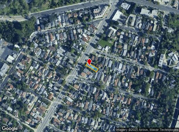
Property Record
5612 Monterey Rd, Los Angeles, CA 90042
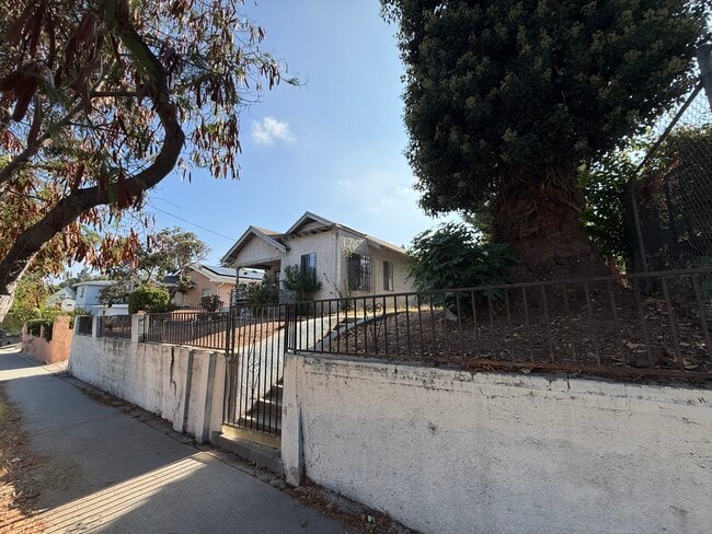

This Property Is For Sale
NEARBY LISTINGS FOR SALE OR LEASE
Property Detail
5612 Monterey Rd
Los Angeles-Long Beach-Glendale, CA
Highland Park Addition
5301-013-017
Los Angeles
Duplex
California
X
0.13 AC
06037C1635F
Monterey Hills
1,348 SF
Los Angeles
DEMOGRAPHICS near 5612 Monterey Rd
1 Mile
3 Mile
5 Mile
2024 Total Population
28,789
243,595
703,866
2029 Population
28,264
240,353
696,357
Pop Growth 2024-2029
(1.82%)
(1.33%)
(1.07%)
Average Age
40
41
41
2024 Total Households
10,919
84,861
252,974
HH Growth 2024-2029
(1.96%)
(1.55%)
(1.20%)
Median Household Inc
$96,790
$98,756
$87,154
Avg Household Size
2.50
2.70
2.60
2024 Avg HH Vehicles
2.00
2.00
2.00
Median Home Value
$916,938
$1,005,108
$953,089
Median Year Built
1963
1952
1959
Nearby Places
- Restaurants
- Banks
- Shops
- Fitness
- Groceries
PUBLIC TRANSPORTATION
TRANSIT/SUBWAY
Highland Park Station (Gold Line - Los Angeles County Metropolitan Transportation Authority (Metro))
DRIVE
WALK
Distance
Highland Park Station (Gold Line - Los Angeles County Metropolitan Transportation Authority (Metro))
3 min
19 min
1.0 mi
COMMUTER RAIL
Union Station (91 Line - Southern California Regional Rail Authority (Metrolink), Antelope Valley Line - Southern California Regional Rail Authority (Metrolink), Orange County Line - Southern California Regional Rail Authority (Metrolink), Riverside Line - Southern California Regional Rail Authority (Metrolink), San Bernardino Line - Southern California Regional Rail Authority (Metrolink), Ventura County Line - Southern California Regional Rail Authority (Metrolink))
DRIVE
WALK
Distance
Union Station (91 Line - Southern California Regional Rail Authority (Metrolink), Antelope Valley Line - Southern California Regional Rail Authority (Metrolink), Orange County Line - Southern California Regional Rail Authority (Metrolink), Riverside Line - Southern California Regional Rail Authority (Metrolink), San Bernardino Line - Southern California Regional Rail Authority (Metrolink), Ventura County Line - Southern California Regional Rail Authority (Metrolink))
12 min
5.5 mi
Cal State La Metrolink Station (Metrolink San Bernardino Line - Metrolink Trains)
DRIVE
WALK
Distance
Cal State La Metrolink Station (Metrolink San Bernardino Line - Metrolink Trains)
13 min
9.5 mi
AIRPORT
Bob Hope
DRIVE
WALK
Distance
Bob Hope
25 min
17.5 mi
Los Angeles International
DRIVE
WALK
Distance
Los Angeles International
32 min
20.5 mi
Long Beach (Daugherty Field)
DRIVE
WALK
Distance
Long Beach (Daugherty Field)
38 min
24.1 mi
Freight Ports
Port of Long Beach
DRIVE
WALK
Distance
Port of Long Beach
40 min
26.9 mi
Nearby Properties
Address
Land Use
TOTAL SIZE
Lot Size
Zoning
Address
Land Use
TOTAL SIZE
Lot Size
Zoning
874,871 SF
25.01 AC
PSC*
Address
Land Use
TOTAL SIZE
Lot Size
Zoning
513,825 SF
4.28 AC
LAC2
Address
Land Use
TOTAL SIZE
Lot Size
Zoning
534,225 SF
Address
Land Use
TOTAL SIZE
Lot Size
Zoning
460,590 SF
23.95 AC
ALMPD*
Address
Land Use
TOTAL SIZE
Lot Size
Zoning
523,298 SF
5.74 AC
PSC-
Address
Land Use
TOTAL SIZE
Lot Size
Zoning
251,317 SF
114.56 AC
LAR1
Address
Land Use
TOTAL SIZE
Lot Size
Zoning
328,737 SF
7.92 AC
LAC2
Address
Land Use
TOTAL SIZE
Lot Size
Zoning
354,299 SF
2.18 AC
LAC2
Address
Land Use
TOTAL SIZE
Lot Size
Zoning
150,608 SF
0.88 AC
LAC2
Address
Land Use
TOTAL SIZE
Lot Size
Zoning
119,455 SF
5.04 AC
LACM
Address
Land Use
TOTAL SIZE
Lot Size
Zoning
252,559 SF
2.87 AC
LAC2
Address
Land Use
TOTAL SIZE
Lot Size
Zoning
130,553 SF
1.93 AC
PSR*
Address
Land Use
TOTAL SIZE
Lot Size
Zoning
75,577 SF
1.92 AC
PSC-
Address
Land Use
TOTAL SIZE
Lot Size
Zoning
172,072 SF
1.82 AC
LAC2
Address
Land Use
TOTAL SIZE
Lot Size
Zoning
198,958 SF
7.50 AC
LCM2*
Address
Land Use
TOTAL SIZE
Lot Size
Zoning
116,109 SF
0.92 AC
LACM
Address
Land Use
TOTAL SIZE
Lot Size
Zoning
118,320 SF
8.01 AC
LAM2
Address
Land Use
TOTAL SIZE
Lot Size
Zoning
63,406 SF
5 AC
LAC4
Address
Land Use
TOTAL SIZE
Lot Size
Zoning
188,634 SF
1.07 AC
LAUI(CA)
Address
Land Use
TOTAL SIZE
Lot Size
Zoning
87,236 SF
2.62 AC
SPP*
Address
Land Use
TOTAL SIZE
Lot Size
Zoning
165,246 SF
1.10 AC
PSR*
Address
Land Use
TOTAL SIZE
Lot Size
Zoning
131,209 SF
1.51 AC
PSC-
Address
Land Use
TOTAL SIZE
Lot Size
Zoning
296,309 SF
5.29 AC
LAM1
Address
Land Use
TOTAL SIZE
Lot Size
Zoning
146,264 SF
1.87 AC
LAMR1
Address
Land Use
TOTAL SIZE
Lot Size
Zoning
64,497 SF
0.80 AC
LAC2
Address
Land Use
TOTAL SIZE
Lot Size
Zoning
155,339 SF
3.99 AC
LAMR1
Address
Land Use
TOTAL SIZE
Lot Size
Zoning
92,530 SF
3.16 AC
LARD1.5
Address
Land Use
TOTAL SIZE
Lot Size
Zoning
180,384 SF
2.03 AC
PSC*
Address
Land Use
TOTAL SIZE
Lot Size
Zoning
435,600 SF
10.57 AC
LACM
Address
Land Use
TOTAL SIZE
Lot Size
Zoning
182,254 SF
2.14 AC
LAUV(CA)
The World's #1 Commercial Real Estate Marketplace
Connect with us
© 2025 CoStar Group
The information above has been obtained from sources believed reliable. While we do not doubt its accuracy we have not verified it and make no guarantee, warranty or representation about it. It is your responsibility to independently confirm its accuracy and completeness. Any projections, opinions, assumptions, or estimates used are for example only and do not represent the current or future performance of the property. The value of this transaction to you depends on tax and other factors which should be evaluated by your tax, financial, and legal advisors. You and your advisors should conduct a careful, independent investigation of the property to determine to your satisfaction the suitability of the property for your needs.