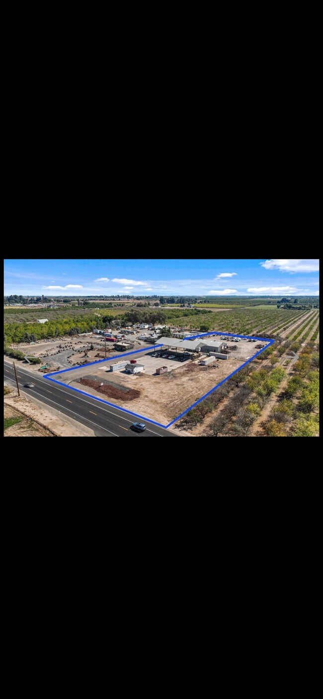
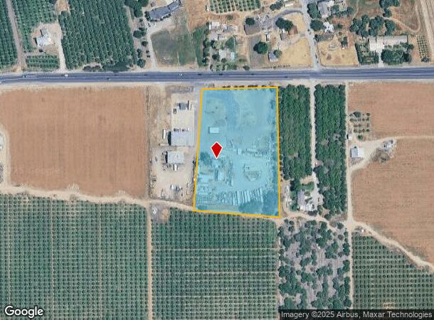
Property Record
5612 Highway 108, Riverbank, CA 95367
Current Lease Availabilities
NEARBY LISTINGS FOR SALE OR LEASE
Property Detail
5612 Highway 108
062-06-21
43PM61
Agriculturalland
Stanislaus
X
California
06077C0695F
4.40 AC
2025
Hughson/Oakdale/Waterford
2025
Stockton/Modesto
000303
Modesto, CA
2,424 SF
DEMOGRAPHICS near 5612 Highway 108
1 Mile
3 Mile
5 Mile
2024 Total Population
2,513
28,465
57,717
2029 Population
2,522
28,501
57,714
Pop Growth 2024-2029
+ 0.36%
+ 0.13%
(0.01%)
Average Age
37
37
38
2024 Total Households
820
9,506
18,876
HH Growth 2024-2029
+ 0.24%
+ 0.11%
(0.03%)
Median Household Inc
$94,949
$75,998
$83,057
Avg Household Size
3.00
2.90
3.00
2024 Avg HH Vehicles
2.00
2.00
2.00
Median Home Value
$451,181
$421,918
$437,397
Median Year Built
1997
1979
1990
Nearby Places
- Restaurants
- Banks
- Shops
- Fitness
- Groceries
PUBLIC TRANSPORTATION
COMMUTER RAIL
Modesto (San Joaquins - Amtrak)
DRIVE
WALK
Distance
Modesto (San Joaquins - Amtrak)
13 min
7.6 mi
AIRPORT
Stockton Metro
DRIVE
WALK
Distance
Stockton Metro
44 min
25.8 mi
Freight Ports
Port of Stockton
DRIVE
WALK
Distance
Port of Stockton
53 min
39.1 mi
Nearby Properties
Address
Land Use
TOTAL SIZE
Lot Size
Zoning
Address
Land Use
TOTAL SIZE
Lot Size
Zoning
330,747 SF
26.73 AC
OAKLM
Address
Land Use
TOTAL SIZE
Lot Size
Zoning
186,665 SF
10.22 AC
Address
Land Use
TOTAL SIZE
Lot Size
Zoning
87,612 SF
4.15 AC
OAKC2
Address
Land Use
TOTAL SIZE
Lot Size
Zoning
543,278 SF
71.53 AC
Address
Land Use
TOTAL SIZE
Lot Size
Zoning
51,000 SF
0.99 AC
Address
Land Use
TOTAL SIZE
Lot Size
Zoning
230,148 SF
13.25 AC
MI
Address
Land Use
TOTAL SIZE
Lot Size
Zoning
151,200 SF
8.60 AC
MI
Address
Land Use
TOTAL SIZE
Lot Size
Zoning
86,946 SF
4.83 AC
OAKPD
Address
Land Use
TOTAL SIZE
Lot Size
Zoning
83,987 SF
4.59 AC
RIVR3
Address
Land Use
TOTAL SIZE
Lot Size
Zoning
117,162 SF
5.17 AC
Address
Land Use
TOTAL SIZE
Lot Size
Zoning
190,416 SF
5.93 AC
Address
Land Use
TOTAL SIZE
Lot Size
Zoning
465,061 SF
26.66 AC
CERM1
Address
Land Use
TOTAL SIZE
Lot Size
Zoning
15,114 SF
1.17 AC
Address
Land Use
TOTAL SIZE
Lot Size
Zoning
1.44 AC
OAKLM
Address
Land Use
TOTAL SIZE
Lot Size
Zoning
133,627 SF
13.33 AC
Address
Land Use
TOTAL SIZE
Lot Size
Zoning
34,331 SF
1.70 AC
OAKC2
Address
Land Use
TOTAL SIZE
Lot Size
Zoning
71,339 SF
4.26 AC
R3
Address
Land Use
TOTAL SIZE
Lot Size
Zoning
69,323 SF
3.77 AC
M
Address
Land Use
TOTAL SIZE
Lot Size
Zoning
32,604 SF
23.08 AC
Address
Land Use
TOTAL SIZE
Lot Size
Zoning
27,483 SF
1.11 AC
Address
Land Use
TOTAL SIZE
Lot Size
Zoning
23,900 SF
3.23 AC
MI
Address
Land Use
TOTAL SIZE
Lot Size
Zoning
46,890 SF
1.85 AC
Address
Land Use
TOTAL SIZE
Lot Size
Zoning
12,583 SF
1.40 AC
Address
Land Use
TOTAL SIZE
Lot Size
Zoning
27,200 SF
1.58 AC
OAKC2
Address
Land Use
TOTAL SIZE
Lot Size
Zoning
23,328 SF
0.82 AC
OAKR3
Address
Land Use
TOTAL SIZE
Lot Size
Zoning
2.43 AC
Address
Land Use
TOTAL SIZE
Lot Size
Zoning
71,207 SF
3.26 AC
Address
Land Use
TOTAL SIZE
Lot Size
Zoning
22,000 SF
2.05 AC
OAKLM
Address
Land Use
TOTAL SIZE
Lot Size
Zoning
27,840 SF
1.96 AC
Address
Land Use
TOTAL SIZE
Lot Size
Zoning
91,072 SF
8.84 AC
OAKC2
The World's #1 Commercial Real Estate Marketplace
Connect with us
© 2025 CoStar Group
The information above has been obtained from sources believed reliable. While we do not doubt its accuracy we have not verified it and make no guarantee, warranty or representation about it. It is your responsibility to independently confirm its accuracy and completeness. Any projections, opinions, assumptions, or estimates used are for example only and do not represent the current or future performance of the property. The value of this transaction to you depends on tax and other factors which should be evaluated by your tax, financial, and legal advisors. You and your advisors should conduct a careful, independent investigation of the property to determine to your satisfaction the suitability of the property for your needs.