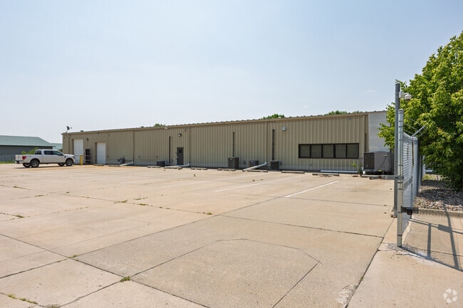
Property Record
5613 Ne 22Nd St, Des Moines, IA 50313


NEARBY LISTINGS FOR SALE OR LEASE
Property Detail
5613 Ne 22Nd St
Des Moines-West Des Moines, IA
Coryn Subdivision
190-00876302000
LOTS 2,3 & 4 CORYN SUBDIVISION
Officebuilding
Polk
X
Iowa
19153C0215F
2,3,4
2024
3.86 AC
2025
Northeast
010601
Des Moines
22,770 SF
DEMOGRAPHICS near 5613 Ne 22Nd St
1 Mile
3 Mile
5 Mile
2024 Total Population
46
25,265
123,701
2029 Population
47
26,224
129,045
Pop Growth 2024-2029
+ 2.17%
+ 3.80%
+ 4.32%
Average Age
41
40
38
2024 Total Households
16
9,910
47,355
HH Growth 2024-2029
+ 6.25%
+ 3.96%
+ 4.51%
Median Household Inc
$55,000
$61,426
$63,543
Avg Household Size
2.30
2.40
2.50
2024 Avg HH Vehicles
2.00
2.00
2.00
Median Home Value
$262,499
$176,951
$169,805
Median Year Built
1974
1968
1970
Nearby Places
Map Layers
Map Styles
 Street
 Aerial
- Restaurants
- Banks
- Shops
- Fitness
- Groceries
PUBLIC TRANSPORTATION
AIRPORT
Des Moines International
DRIVE
WALK
Distance
Des Moines International
24 min
13.2 mi
SALE & LEASE HISTORY
LISTING DATE
SALE/LEASE

Mar 04, 2025
For Sale
Mar 04, 2025
For Lease
Nearby Properties
Address
Land Use
TOTAL SIZE
Lot Size
Zoning
Address
Land Use
TOTAL SIZE
Lot Size
Zoning
723,056 SF
83.96 AC
M1
Address
Land Use
TOTAL SIZE
Lot Size
Zoning
857,109 SF
73.97 AC
LI
Address
Land Use
TOTAL SIZE
Lot Size
Zoning
644,568 SF
29.90 AC
M-1
Address
Land Use
TOTAL SIZE
Lot Size
Zoning
675,000 SF
65.27 AC
Address
Land Use
TOTAL SIZE
Lot Size
Zoning
600,000 SF
40.15 AC
Address
Land Use
TOTAL SIZE
Lot Size
Zoning
463,530 SF
35.91 AC
M-1
Address
Land Use
TOTAL SIZE
Lot Size
Zoning
350,150 SF
35.34 AC
Address
Land Use
TOTAL SIZE
Lot Size
Zoning
296,500 SF
24.36 AC
Address
Land Use
TOTAL SIZE
Lot Size
Zoning
274,300 SF
24.85 AC
Address
Land Use
TOTAL SIZE
Lot Size
Zoning
312,500 SF
38.14 AC
Address
Land Use
TOTAL SIZE
Lot Size
Zoning
263,250 SF
30.10 AC
M-1
Address
Land Use
TOTAL SIZE
Lot Size
Zoning
198,454 SF
12.04 AC
Address
Land Use
TOTAL SIZE
Lot Size
Zoning
320,429 SF
22.34 AC
R3
Address
Land Use
TOTAL SIZE
Lot Size
Zoning
300,000 SF
18.98 AC
Address
Land Use
TOTAL SIZE
Lot Size
Zoning
529,161 SF
33.60 AC
HI
Address
Land Use
TOTAL SIZE
Lot Size
Zoning
200,860 SF
11.25 AC
Address
Land Use
TOTAL SIZE
Lot Size
Zoning
126,935 SF
28.61 AC
Address
Land Use
TOTAL SIZE
Lot Size
Zoning
130,496 SF
39.96 AC
HI
Address
Land Use
TOTAL SIZE
Lot Size
Zoning
200,220 SF
15.61 AC
Address
Land Use
TOTAL SIZE
Lot Size
Zoning
275,000 SF
16.17 AC
HI
Address
Land Use
TOTAL SIZE
Lot Size
Zoning
603,502 SF
33.03 AC
M-1
Address
Land Use
TOTAL SIZE
Lot Size
Zoning
200,688 SF
20.26 AC
Address
Land Use
TOTAL SIZE
Lot Size
Zoning
220,740 SF
23.21 AC
Address
Land Use
TOTAL SIZE
Lot Size
Zoning
206,000 SF
19.12 AC
Address
Land Use
TOTAL SIZE
Lot Size
Zoning
90,381 SF
19.28 AC
R-3
Address
Land Use
TOTAL SIZE
Lot Size
Zoning
1,838,971 SF
76.24 AC
HI
Address
Land Use
TOTAL SIZE
Lot Size
Zoning
170,872 SF
25 AC
Address
Land Use
TOTAL SIZE
Lot Size
Zoning
184,320 SF
9.68 AC
Address
Land Use
TOTAL SIZE
Lot Size
Zoning
136,900 SF
28.82 AC
Address
Land Use
TOTAL SIZE
Lot Size
Zoning
180,000 SF
11.72 AC
The World's #1 Commercial Real Estate Marketplace
Connect with us
© 2026 CoStar Group
The information above has been obtained from sources believed reliable. While we do not doubt its accuracy we have not verified it and make no guarantee, warranty or representation about it. It is your responsibility to independently confirm its accuracy and completeness. Any projections, opinions, assumptions, or estimates used are for example only and do not represent the current or future performance of the property. The value of this transaction to you depends on tax and other factors which should be evaluated by your tax, financial, and legal advisors. You and your advisors should conduct a careful, independent investigation of the property to determine to your satisfaction the suitability of the property for your needs.