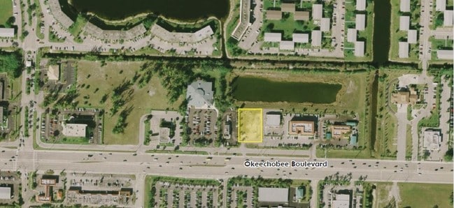
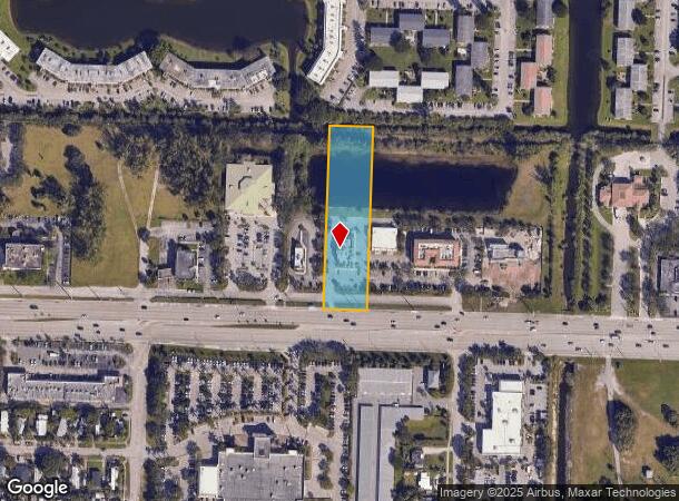
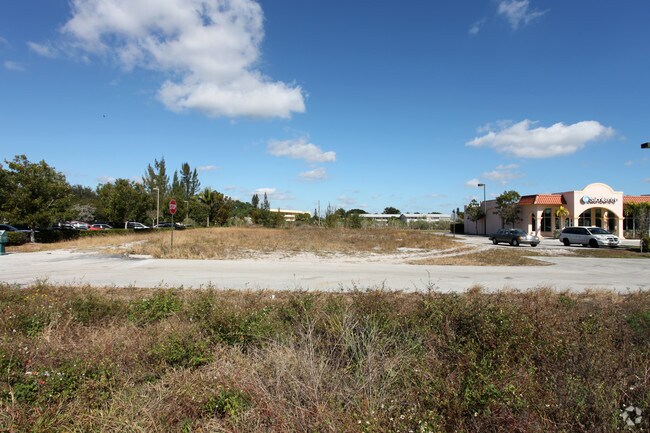
Property Record
5613 Okeechobee Blvd, West Palm Beach, FL 33417

NEARBY LISTINGS FOR SALE OR LEASE
Property Detail
5613 Okeechobee Blvd
00-42-43-23-42-002-0000
Gladstone Commercial Center
Storemultistory
GLADSTONE COMMERCIAL CENTER PAR B
AE
Palm Beach
12099C0559F
Florida
2024
1.80 AC
2025
West Palm Beach
001913
South Florida
3,680 SF
West Palm Beach-Boca Raton-Delray Beach, FL
DEMOGRAPHICS near 5613 Okeechobee Blvd
1 Mile
3 Mile
5 Mile
2024 Total Population
22,229
104,870
255,754
2029 Population
23,486
108,577
265,301
Pop Growth 2024-2029
+ 5.65%
+ 3.53%
+ 3.73%
Average Age
51
40
40
2024 Total Households
11,100
41,632
99,421
HH Growth 2024-2029
+ 5.99%
+ 3.27%
+ 3.44%
Median Household Inc
$33,352
$50,903
$53,541
Avg Household Size
1.90
2.40
2.40
2024 Avg HH Vehicles
1.00
1.00
2.00
Median Home Value
$81,461
$208,191
$245,711
Median Year Built
1976
1985
1985
Nearby Places
Map Layers
Map Styles
 Street
 Aerial
- Restaurants
- Banks
- Shops
- Fitness
- Groceries
PUBLIC TRANSPORTATION
COMMUTER RAIL
West Palm Beach (Tri-County Commuter - South Florida Regional Transportation Authority (Tri-Rail))
DRIVE
WALK
Distance
West Palm Beach (Tri-County Commuter - South Florida Regional Transportation Authority (Tri-Rail))
10 min
4.9 mi
West Palm Beach (Mainline - Brightline)
DRIVE
WALK
Distance
West Palm Beach (Mainline - Brightline)
11 min
5.3 mi
AIRPORT
Palm Beach International
DRIVE
WALK
Distance
Palm Beach International
11 min
4.7 mi
Freight Ports
Port of Palm Beach
DRIVE
WALK
Distance
Port of Palm Beach
18 min
8.9 mi
Nearby Properties
Address
Land Use
TOTAL SIZE
Lot Size
Zoning
Address
Land Use
TOTAL SIZE
Lot Size
Zoning
3,150,355 SF
616.71 AC
PO
Address
Land Use
TOTAL SIZE
Lot Size
Zoning
492,288 SF
58.55 AC
CPD
Address
Land Use
TOTAL SIZE
Lot Size
Zoning
644,690 SF
44.88 AC
MUPD
Address
Land Use
TOTAL SIZE
Lot Size
Zoning
490,757 SF
12.11 AC
PIPD
Address
Land Use
TOTAL SIZE
Lot Size
Zoning
303,776 SF
27.63 AC
CPD
Address
Land Use
TOTAL SIZE
Lot Size
Zoning
586,386 SF
19.67 AC
RPD
Address
Land Use
TOTAL SIZE
Lot Size
Zoning
546,847 SF
19.50 AC
RPD
Address
Land Use
TOTAL SIZE
Lot Size
Zoning
561,484 SF
21.86 AC
PO
Address
Land Use
TOTAL SIZE
Lot Size
Zoning
314,116 SF
10.25 AC
MF20
Address
Land Use
TOTAL SIZE
Lot Size
Zoning
347,853 SF
46.24 AC
PIPD
Address
Land Use
TOTAL SIZE
Lot Size
Zoning
150,344 SF
203.77 AC
PO
Address
Land Use
TOTAL SIZE
Lot Size
Zoning
406,623 SF
47.23 AC
MF14
Address
Land Use
TOTAL SIZE
Lot Size
Zoning
371,177 SF
17.38 AC
RPD
Address
Land Use
TOTAL SIZE
Lot Size
Zoning
328,512 SF
15.27 AC
PUD
Address
Land Use
TOTAL SIZE
Lot Size
Zoning
293,524 SF
11.14 AC
RPD
Address
Land Use
TOTAL SIZE
Lot Size
Zoning
210,445 SF
11.18 AC
MUPD
Address
Land Use
TOTAL SIZE
Lot Size
Zoning
334,396 SF
19.54 AC
PO
Address
Land Use
TOTAL SIZE
Lot Size
Zoning
232,751 SF
12.67 AC
RPD
Address
Land Use
TOTAL SIZE
Lot Size
Zoning
302,217 SF
18.17 AC
RPD
Address
Land Use
TOTAL SIZE
Lot Size
Zoning
178,614 SF
10.42 AC
PUD
Address
Land Use
TOTAL SIZE
Lot Size
Zoning
307,554 SF
6.10 AC
CSPD
Address
Land Use
TOTAL SIZE
Lot Size
Zoning
247,028 SF
14.30 AC
RS
Address
Land Use
TOTAL SIZE
Lot Size
Zoning
242,559 SF
7.29 AC
RM
Address
Land Use
TOTAL SIZE
Lot Size
Zoning
172,493 SF
20.46 AC
CPD
Address
Land Use
TOTAL SIZE
Lot Size
Zoning
196,683 SF
8.97 AC
RPD
Address
Land Use
TOTAL SIZE
Lot Size
Zoning
347,973 SF
17.87 AC
RM
Address
Land Use
TOTAL SIZE
Lot Size
Zoning
248,196 SF
8.74 AC
RPD
Address
Land Use
TOTAL SIZE
Lot Size
Zoning
209,824 SF
73.38 AC
PO
Address
Land Use
TOTAL SIZE
Lot Size
Zoning
299,161 SF
16.85 AC
CSPD
Address
Land Use
TOTAL SIZE
Lot Size
Zoning
225,393 SF
22.54 AC
MUPD
The World's #1 Commercial Real Estate Marketplace
Connect with us
© 2025 CoStar Group
The information above has been obtained from sources believed reliable. While we do not doubt its accuracy we have not verified it and make no guarantee, warranty or representation about it. It is your responsibility to independently confirm its accuracy and completeness. Any projections, opinions, assumptions, or estimates used are for example only and do not represent the current or future performance of the property. The value of this transaction to you depends on tax and other factors which should be evaluated by your tax, financial, and legal advisors. You and your advisors should conduct a careful, independent investigation of the property to determine to your satisfaction the suitability of the property for your needs.