Property Record
5615 W 32Nd St, Joplin, MO 64804

NEARBY LISTINGS FOR SALE OR LEASE
-
-
View all Joplin listings for sale on LoopNet.com
Property Detail
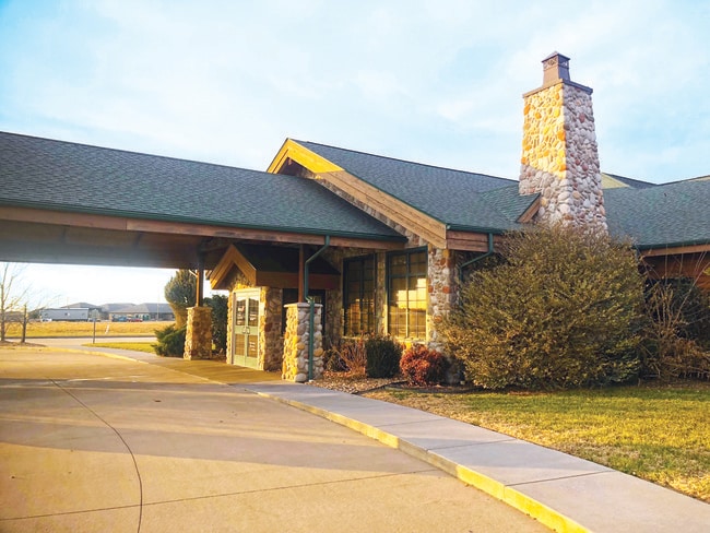
5615 W 32Nd St
18-6.0-13-00-000-001.001
Jop
Apartment
JOP MISC COM SE COR SE SE N 88 DEG W 1192.53 N 13 DEG E 158.88 N 17 DEG E 140.28 TO POB TH N 13 DEG E 372.06 TH ALG CURV LFT W/RAD 1030 AN ARC DIST 207.58 N 136.71 E
X
Jasper
29097C0265E
Missouri
2024
9.96 AC
2025
Missouri South Area
010901
Other Market Areas
24,814 SF
Joplin, MO
DEMOGRAPHICS near 5615 W 32Nd St
1 Mile
3 Mile
5 Mile
2024 Total Population
1,570
11,034
41,867
2029 Population
1,648
11,324
43,270
Pop Growth 2024-2029
+ 4.97%
+ 2.63%
+ 3.35%
Average Age
42
41
40
2024 Total Households
619
4,479
17,247
HH Growth 2024-2029
+ 5.17%
+ 2.66%
+ 3.42%
Median Household Inc
$64,528
$56,551
$47,534
Avg Household Size
2.40
2.40
2.30
2024 Avg HH Vehicles
2.00
2.00
2.00
Median Home Value
$171,402
$154,332
$135,427
Median Year Built
2003
1993
1976
Nearby Places
Map Layers
Map Styles
 Street
 Aerial
- Restaurants
- Banks
- Shops
- Fitness
- Groceries
SALE & LEASE HISTORY
LISTING DATE
SALE/LEASE

Jan 03, 2019
For Sale
Nearby Properties
Address
Land Use
TOTAL SIZE
Lot Size
Zoning
Address
Land Use
TOTAL SIZE
Lot Size
Zoning
76,806 SF
13.20 AC
Address
Land Use
TOTAL SIZE
Lot Size
Zoning
107,085 SF
30.80 AC
C2
Address
Land Use
TOTAL SIZE
Lot Size
Zoning
57,574 SF
23.57 AC
Address
Land Use
TOTAL SIZE
Lot Size
Zoning
26,136 SF
6.55 AC
Address
Land Use
TOTAL SIZE
Lot Size
Zoning
28,285 SF
8.99 AC
Address
Land Use
TOTAL SIZE
Lot Size
Zoning
24,690 SF
2.21 AC
R1
Address
Land Use
TOTAL SIZE
Lot Size
Zoning
70,785 SF
31.30 AC
R1
Address
Land Use
TOTAL SIZE
Lot Size
Zoning
19,292 SF
9.85 AC
Address
Land Use
TOTAL SIZE
Lot Size
Zoning
30,000 SF
3.61 AC
Address
Land Use
TOTAL SIZE
Lot Size
Zoning
88,310 SF
4.72 AC
Address
Land Use
TOTAL SIZE
Lot Size
Zoning
12,530 SF
1.08 AC
Address
Land Use
TOTAL SIZE
Lot Size
Zoning
323,898 SF
109.92 AC
Address
Land Use
TOTAL SIZE
Lot Size
Zoning
62,592 SF
7.78 AC
Address
Land Use
TOTAL SIZE
Lot Size
Zoning
433,258 SF
45.61 AC
Address
Land Use
TOTAL SIZE
Lot Size
Zoning
7,756 SF
3.87 AC
Address
Land Use
TOTAL SIZE
Lot Size
Zoning
18,812 SF
1.13 AC
Address
Land Use
TOTAL SIZE
Lot Size
Zoning
11,377 SF
0.92 AC
Address
Land Use
TOTAL SIZE
Lot Size
Zoning
12,330 SF
1.07 AC
Address
Land Use
TOTAL SIZE
Lot Size
Zoning
26,316 SF
4 AC
Address
Land Use
TOTAL SIZE
Lot Size
Zoning
24,364 SF
1.80 AC
R1
Address
Land Use
TOTAL SIZE
Lot Size
Zoning
11,932 SF
1.59 AC
Address
Land Use
TOTAL SIZE
Lot Size
Zoning
5,505 SF
2.59 AC
Address
Land Use
TOTAL SIZE
Lot Size
Zoning
7,402 SF
2.42 AC
Address
Land Use
TOTAL SIZE
Lot Size
Zoning
60,288 SF
6.64 AC
Address
Land Use
TOTAL SIZE
Lot Size
Zoning
6,282 SF
0.69 AC
R1
Address
Land Use
TOTAL SIZE
Lot Size
Zoning
14,160 SF
40.78 AC
Address
Land Use
TOTAL SIZE
Lot Size
Zoning
95,780 SF
11.35 AC
Address
Land Use
TOTAL SIZE
Lot Size
Zoning
41,168 SF
4.74 AC
Address
Land Use
TOTAL SIZE
Lot Size
Zoning
67,965 SF
2.72 AC
Address
Land Use
TOTAL SIZE
Lot Size
Zoning
19,200 SF
2.63 AC
The World's #1 Commercial Real Estate Marketplace
Connect with us
© 2025 CoStar Group
The information above has been obtained from sources believed reliable. While we do not doubt its accuracy we have not verified it and make no guarantee, warranty or representation about it. It is your responsibility to independently confirm its accuracy and completeness. Any projections, opinions, assumptions, or estimates used are for example only and do not represent the current or future performance of the property. The value of this transaction to you depends on tax and other factors which should be evaluated by your tax, financial, and legal advisors. You and your advisors should conduct a careful, independent investigation of the property to determine to your satisfaction the suitability of the property for your needs.