Property Record
5617 E Evans Rd, San Antonio, TX 78266


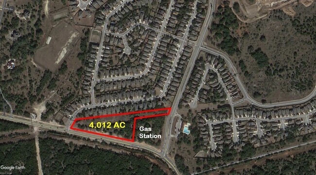

Property Detail
5617 E Evans Rd
San Antonio-New Braunfels, TX
CB 4913A BLK 1 LOT 33 WORTHHAM OAKS UT-1 PUD PLAT 9567/121/123
04913-101-0330
BEXAR
Servicestation
Texas
B and X Area of moderate flood hazard, usually the area between the limits of the 100-year and 500-year floods.
33
2024
2.64 AC
2025
Far North Central
121912
San Antonio
46,966 SF
NEARBY LISTINGS FOR SALE OR LEASE
DEMOGRAPHICS near 5617 E Evans Rd
1 mile
3 mile
5 mile
2025 Total Population
6,234
24,482
117,309
2030 Population
6,676
26,060
124,413
Pop Growth 2025-2030
+ 7.09%
+ 6.45%
+ 6.06%
Average Age
38
37
38
2025 Total Households
2,200
8,698
41,767
HH Growth 2025-2030
+ 7.23%
+ 6.67%
+ 6.24%
Median Household Inc
$131,160
$113,395
$101,823
Avg Household Size
2.80
2.80
2.80
2025 Avg HH Vehicles
2.00
2.00
2.00
Median Home Value
$406,396
$385,940
$347,823
Median Year Built
2011
2010
2004
Nearby Places
Map Layers
Map Styles
 Street
 Aerial
Layers
 Traffic
 Biking
Places
Listings with unknown addresses are not visible on the map
- Restaurants
- Banks
- Shops
- Fitness
- Groceries
PUBLIC TRANSPORTATION
AIRPORT
San Antonio International
Drive
Walk
Distance
San Antonio International
23 min
13.9 mi
Freight Ports
Calhoun Port
Drive
Walk
Distance
Calhoun Port
187 min
152.7 mi
SALE & LEASE HISTORY
LISTING DATE
SALE/LEASE

Sep 24, 2016
For Sale
Nearby Properties
Address
Land Use
TOTAL SIZE
Lot Size
Zoning
Address
Land Use
TOTAL SIZE
Lot Size
Zoning
1,243,450 SF
77.19 AC
Address
Land Use
TOTAL SIZE
Lot Size
Zoning
390,736 SF
31.72 AC
Address
Land Use
TOTAL SIZE
Lot Size
Zoning
5,687 SF
19.39 AC
Address
Land Use
TOTAL SIZE
Lot Size
Zoning
37,195 SF
1,118.06 AC
Address
Land Use
TOTAL SIZE
Lot Size
Zoning
371,475 SF
20 AC
Address
Land Use
TOTAL SIZE
Lot Size
Zoning
306,523 SF
16.29 AC
Address
Land Use
TOTAL SIZE
Lot Size
Zoning
240,644 SF
16.35 AC
Address
Land Use
TOTAL SIZE
Lot Size
Zoning
258,951 SF
15.43 AC
Address
Land Use
TOTAL SIZE
Lot Size
Zoning
148,944 SF
29.35 AC
Address
Land Use
TOTAL SIZE
Lot Size
Zoning
364,250 SF
48.51 AC
Address
Land Use
TOTAL SIZE
Lot Size
Zoning
351,802 SF
43.07 AC
Address
Land Use
TOTAL SIZE
Lot Size
Zoning
174,447 SF
14.64 AC
Address
Land Use
TOTAL SIZE
Lot Size
Zoning
65,271 SF
1,351.01 AC
Address
Land Use
TOTAL SIZE
Lot Size
Zoning
198,753 SF
10.57 AC
Address
Land Use
TOTAL SIZE
Lot Size
Zoning
155,100 SF
11.43 AC
Address
Land Use
TOTAL SIZE
Lot Size
Zoning
89,512 SF
10.16 AC
Address
Land Use
TOTAL SIZE
Lot Size
Zoning
1,686 SF
1,076.95 AC
Address
Land Use
TOTAL SIZE
Lot Size
Zoning
95,004 SF
12.02 AC
Address
Land Use
TOTAL SIZE
Lot Size
Zoning
109,246 SF
2.72 AC
Address
Land Use
TOTAL SIZE
Lot Size
Zoning
129,792 SF
9.80 AC
Address
Land Use
TOTAL SIZE
Lot Size
Zoning
114,348 SF
2.14 AC
Address
Land Use
TOTAL SIZE
Lot Size
Zoning
125,900 SF
7.54 AC
Address
Land Use
TOTAL SIZE
Lot Size
Zoning
37,816 SF
4.95 AC
Address
Land Use
TOTAL SIZE
Lot Size
Zoning
451.18 AC
Address
Land Use
TOTAL SIZE
Lot Size
Zoning
3,425 SF
271.69 AC
Address
Land Use
TOTAL SIZE
Lot Size
Zoning
20,639 SF
16.16 AC
Address
Land Use
TOTAL SIZE
Lot Size
Zoning
88,445 SF
114.67 AC
Address
Land Use
TOTAL SIZE
Lot Size
Zoning
51,776 SF
9.15 AC
Address
Land Use
TOTAL SIZE
Lot Size
Zoning
263.59 AC
Address
Land Use
TOTAL SIZE
Lot Size
Zoning
15,355 SF
3.25 AC
The World's #1 Commercial Real Estate Marketplace
Connect with us
© 2026 CoStar Group
The information above has been obtained from sources believed reliable. While we do not doubt its accuracy we have not verified it and make no guarantee, warranty or representation about it. It is your responsibility to independently confirm its accuracy and completeness. Any projections, opinions, assumptions, or estimates used are for example only and do not represent the current or future performance of the property. The value of this transaction to you depends on tax and other factors which should be evaluated by your tax, financial, and legal advisors. You and your advisors should conduct a careful, independent investigation of the property to determine to your satisfaction the suitability of the property for your needs.