Property Record
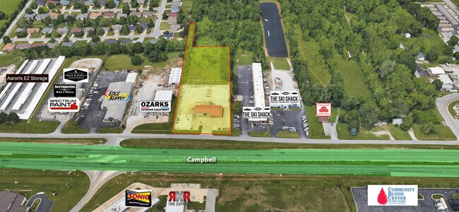
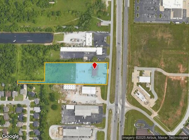
5617 S Campbell Ave, Springfield, MO 65810
NEARBY LISTINGS FOR SALE OR LEASE
Property Detail
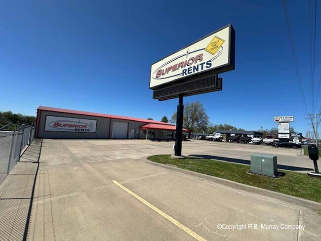
5617 S Campbell Ave
88-18-23-400-470
3.23A M/L BEG 1039.17 FT N & 39.37 FT W SE COR SE1/4 W 901.66 FT N 25 FT E 272.8 FT N 181.82 FT E 634.14 FT SLY 202.71 FT TO BEG 23/28/22
Storebuilding
Greene
X
Missouri
29043C0056D
3.23 AC
2025
Southwest
2025
Springfield
004109
Springfield, MO
DEMOGRAPHICS near 5617 S Campbell Ave
1 Mile
3 Mile
5 Mile
2024 Total Population
6,962
41,148
123,995
2029 Population
7,120
42,467
130,011
Pop Growth 2024-2029
+ 2.27%
+ 3.21%
+ 4.85%
Average Age
40
42
41
2024 Total Households
2,747
17,671
53,356
HH Growth 2024-2029
+ 2.29%
+ 3.18%
+ 4.73%
Median Household Inc
$86,502
$67,658
$62,111
Avg Household Size
2.50
2.30
2.30
2024 Avg HH Vehicles
2.00
2.00
2.00
Median Home Value
$254,702
$238,926
$210,376
Median Year Built
1994
1991
1989
Nearby Places
Map Layers
Map Styles
 Street
 Aerial
- Restaurants
- Banks
- Shops
- Fitness
- Groceries
PUBLIC TRANSPORTATION
AIRPORT
Springfield-Branson Ntl
DRIVE
WALK
Distance
Springfield-Branson Ntl
31 min
16.3 mi
Freight Ports
Tulsa Port of Inola
DRIVE
WALK
Distance
Tulsa Port of Inola
194 min
173.9 mi
SALE & LEASE HISTORY
LISTING DATE
SALE/LEASE

Jun 24, 2024
For Sale
Nearby Properties
Address
Land Use
TOTAL SIZE
Lot Size
Zoning
Address
Land Use
TOTAL SIZE
Lot Size
Zoning
18.52 AC
INC
Address
Land Use
TOTAL SIZE
Lot Size
Zoning
15.46 AC
Address
Land Use
TOTAL SIZE
Lot Size
Zoning
284,904 SF
24.38 AC
INC
Address
Land Use
TOTAL SIZE
Lot Size
Zoning
180,665 SF
6.36 AC
INC
Address
Land Use
TOTAL SIZE
Lot Size
Zoning
15.46 AC
INC.
Address
Land Use
TOTAL SIZE
Lot Size
Zoning
1.98 AC
INC.
Address
Land Use
TOTAL SIZE
Lot Size
Zoning
105,278 SF
0.54 AC
INC
Address
Land Use
TOTAL SIZE
Lot Size
Zoning
108,880 SF
3.62 AC
INC
Address
Land Use
TOTAL SIZE
Lot Size
Zoning
26.03 AC
INC
Address
Land Use
TOTAL SIZE
Lot Size
Zoning
11.56 AC
INC
Address
Land Use
TOTAL SIZE
Lot Size
Zoning
140,147 SF
17.64 AC
INC
Address
Land Use
TOTAL SIZE
Lot Size
Zoning
42,540 SF
3.63 AC
INC
Address
Land Use
TOTAL SIZE
Lot Size
Zoning
30,400 SF
9.05 AC
INC
Address
Land Use
TOTAL SIZE
Lot Size
Zoning
6.50 AC
INC.
Address
Land Use
TOTAL SIZE
Lot Size
Zoning
27.78 AC
INC
Address
Land Use
TOTAL SIZE
Lot Size
Zoning
86,566 SF
9.63 AC
INC
Address
Land Use
TOTAL SIZE
Lot Size
Zoning
Address
Land Use
TOTAL SIZE
Lot Size
Zoning
47,214 SF
4.25 AC
INC
Address
Land Use
TOTAL SIZE
Lot Size
Zoning
10.53 AC
Address
Land Use
TOTAL SIZE
Lot Size
Zoning
Address
Land Use
TOTAL SIZE
Lot Size
Zoning
5.72 AC
INC
Address
Land Use
TOTAL SIZE
Lot Size
Zoning
370,716 SF
31.90 AC
INC
Address
Land Use
TOTAL SIZE
Lot Size
Zoning
18.16 AC
Address
Land Use
TOTAL SIZE
Lot Size
Zoning
4.12 AC
INC
Address
Land Use
TOTAL SIZE
Lot Size
Zoning
54,350 SF
9.39 AC
INC
Address
Land Use
TOTAL SIZE
Lot Size
Zoning
5.59 AC
INC
Address
Land Use
TOTAL SIZE
Lot Size
Zoning
8.26 AC
INC
Address
Land Use
TOTAL SIZE
Lot Size
Zoning
3.97 AC
INC.
Address
Land Use
TOTAL SIZE
Lot Size
Zoning
21.59 AC
INC
Address
Land Use
TOTAL SIZE
Lot Size
Zoning
2.84 AC
INC
The World's #1 Commercial Real Estate Marketplace
Connect with us
© 2025 CoStar Group
The information above has been obtained from sources believed reliable. While we do not doubt its accuracy we have not verified it and make no guarantee, warranty or representation about it. It is your responsibility to independently confirm its accuracy and completeness. Any projections, opinions, assumptions, or estimates used are for example only and do not represent the current or future performance of the property. The value of this transaction to you depends on tax and other factors which should be evaluated by your tax, financial, and legal advisors. You and your advisors should conduct a careful, independent investigation of the property to determine to your satisfaction the suitability of the property for your needs.