Property Record
5618 Freeport Blvd, Sacramento, CA 95822
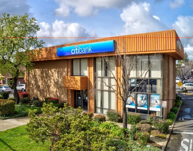


This Property Is For Sale
Current Lease Availabilities
NEARBY LISTINGS FOR SALE OR LEASE
Property Detail
5618 Freeport Blvd
025-0033-028
POR OF NW 1/4 OF SEC 25, T 8 N, R 4 E, MDB&M DESC AS BEG AT PT LOC N 14%4040E 233.65 FT & S 89%5913E 225.07 FT FR SELY COR
Financialbuilding
Sacramento
X
California
06067C0190H
217
2024
0.51 AC
2025
South Sacramento
003300
Sacramento
3,772 SF
Sacramento--Roseville--Arden-Arcade, CA
DEMOGRAPHICS near 5618 Freeport Blvd
1 Mile
3 Mile
5 Mile
2024 Total Population
13,490
155,859
381,701
2029 Population
13,573
157,076
385,284
Pop Growth 2024-2029
+ 0.62%
+ 0.78%
+ 0.94%
Average Age
43
39
39
2024 Total Households
5,730
58,413
144,178
HH Growth 2024-2029
+ 0.59%
+ 0.78%
+ 1.07%
Median Household Inc
$84,383
$72,170
$71,815
Avg Household Size
2.30
2.60
2.50
2024 Avg HH Vehicles
2.00
2.00
2.00
Median Home Value
$544,361
$507,566
$470,629
Median Year Built
1955
1963
1968
Nearby Places
Map Layers
Map Styles
 Street
 Aerial
- Restaurants
- Banks
- Shops
- Fitness
- Groceries
PUBLIC TRANSPORTATION
TRANSIT/SUBWAY
Fruitridge (Blue Line - Sacramento Regional Transit District Light Rail (The RT))
DRIVE
WALK
Distance
Fruitridge (Blue Line - Sacramento Regional Transit District Light Rail (The RT))
3 min
20 min
1.1 mi
COMMUTER RAIL
Sacramento (Capitol Corridor - Capitol Corridor Joint Powers Authority)
DRIVE
WALK
Distance
Sacramento (Capitol Corridor - Capitol Corridor Joint Powers Authority)
10 min
6.0 mi
AIRPORT
Sacramento International
DRIVE
WALK
Distance
Sacramento International
24 min
16.4 mi
Freight Ports
Port of Stockton
DRIVE
WALK
Distance
Port of Stockton
50 min
42.3 mi
Nearby Properties
Address
Land Use
TOTAL SIZE
Lot Size
Zoning
Address
Land Use
TOTAL SIZE
Lot Size
Zoning
R-4-PUD C-
Address
Land Use
TOTAL SIZE
Lot Size
Zoning
253,984 SF
11.58 AC
R-2B-PUD
Address
Land Use
TOTAL SIZE
Lot Size
Zoning
180,344 SF
11.86 AC
R-2A
Address
Land Use
TOTAL SIZE
Lot Size
Zoning
R-4-PUD
Address
Land Use
TOTAL SIZE
Lot Size
Zoning
1.15 AC
R-1
Address
Land Use
TOTAL SIZE
Lot Size
Zoning
213,260 SF
14.35 AC
R-3-R
Address
Land Use
TOTAL SIZE
Lot Size
Zoning
140,408 SF
5.90 AC
R-3
Address
Land Use
TOTAL SIZE
Lot Size
Zoning
64,082 SF
2.38 AC
R-1
Address
Land Use
TOTAL SIZE
Lot Size
Zoning
127,062 SF
8.50 AC
C2
Address
Land Use
TOTAL SIZE
Lot Size
Zoning
267,580 SF
16.12 AC
R-1A
Address
Land Use
TOTAL SIZE
Lot Size
Zoning
65,933 SF
11.09 AC
C2
Address
Land Use
TOTAL SIZE
Lot Size
Zoning
Address
Land Use
TOTAL SIZE
Lot Size
Zoning
102,930 SF
4.87 AC
R-3
Address
Land Use
TOTAL SIZE
Lot Size
Zoning
27,288 SF
1.25 AC
C-2-SPD
Address
Land Use
TOTAL SIZE
Lot Size
Zoning
181,766 SF
4.79 AC
R-4-PUD R-
Address
Land Use
TOTAL SIZE
Lot Size
Zoning
95,548 SF
24.25 AC
R-1
Address
Land Use
TOTAL SIZE
Lot Size
Zoning
227,396 SF
15.76 AC
R-2A-R-EA-
Address
Land Use
TOTAL SIZE
Lot Size
Zoning
91,586 SF
6.03 AC
R-3-R
Address
Land Use
TOTAL SIZE
Lot Size
Zoning
100,704 SF
5.63 AC
RD-20
Address
Land Use
TOTAL SIZE
Lot Size
Zoning
84,087 SF
4.11 AC
R-3-R
Address
Land Use
TOTAL SIZE
Lot Size
Zoning
162,259 SF
12.73 AC
R-3
Address
Land Use
TOTAL SIZE
Lot Size
Zoning
53,967 SF
8.77 AC
SC-PUD
Address
Land Use
TOTAL SIZE
Lot Size
Zoning
129,305 SF
9.37 AC
C-2-SPD
Address
Land Use
TOTAL SIZE
Lot Size
Zoning
55,537 SF
3.67 AC
SC-PUD
Address
Land Use
TOTAL SIZE
Lot Size
Zoning
113,759 SF
8.30 AC
C-2-SPD
Address
Land Use
TOTAL SIZE
Lot Size
Zoning
85,429 SF
3.67 AC
F C-2-R
Address
Land Use
TOTAL SIZE
Lot Size
Zoning
55,164 SF
9.09 AC
C-2-EA-4 C
Address
Land Use
TOTAL SIZE
Lot Size
Zoning
79,915 SF
3.70 AC
R-3
Address
Land Use
TOTAL SIZE
Lot Size
Zoning
105,700 SF
12.41 AC
C-2-R
Address
Land Use
TOTAL SIZE
Lot Size
Zoning
82,404 SF
4.38 AC
RD-30 (NPA
The World's #1 Commercial Real Estate Marketplace
Connect with us
© 2025 CoStar Group
The information above has been obtained from sources believed reliable. While we do not doubt its accuracy we have not verified it and make no guarantee, warranty or representation about it. It is your responsibility to independently confirm its accuracy and completeness. Any projections, opinions, assumptions, or estimates used are for example only and do not represent the current or future performance of the property. The value of this transaction to you depends on tax and other factors which should be evaluated by your tax, financial, and legal advisors. You and your advisors should conduct a careful, independent investigation of the property to determine to your satisfaction the suitability of the property for your needs.