Property Record
558 Goodman Rd E, Southaven, MS 38671


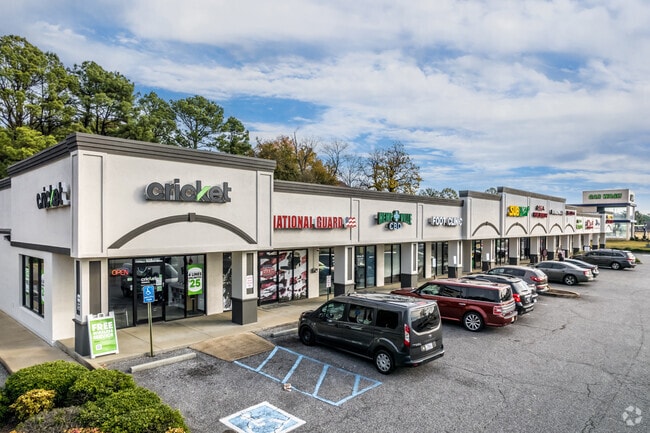
Current Lease Availabilities
Property Detail
558 Goodman Rd E
1079300000003400
30-1-7 SOUTHAVEN INC
Commercialnec
Desoto
C-4
Mississippi
B and X Area of moderate flood hazard, usually the area between the limits of the 100-year and 500-year floods.
34
2025
1 AC
2025
Southaven-Horn Lake
070522
Memphis
14,789 SF
Memphis, TN-MS-AR
NEARBY LISTINGS FOR SALE OR LEASE
DEMOGRAPHICS near 558 Goodman Rd E
1 mile
3 mile
5 mile
2025 Total Population
4,932
44,007
109,681
2030 Population
5,093
45,868
112,864
Pop Growth 2025-2030
+ 3.26%
+ 4.23%
+ 2.90%
Average Age
41
38
38
2025 Total Households
1,993
17,143
41,043
HH Growth 2025-2030
+ 3.26%
+ 4.30%
+ 2.92%
Median Household Inc
$77,916
$64,862
$66,702
Avg Household Size
2.40
2.50
2.60
2025 Avg HH Vehicles
2.00
2.00
2.00
Median Home Value
$189,241
$186,058
$209,465
Median Year Built
1990
1992
1990
Nearby Places
Map Layers
Map Styles
 Street
 Aerial
Layers
 Traffic
 Biking
Places
Listings with unknown addresses are not visible on the map
- Restaurants
- Banks
- Shops
- Fitness
- Groceries
PUBLIC TRANSPORTATION
AIRPORT
Memphis International
Drive
Walk
Distance
Memphis International
13 min
8.0 mi
Freight Ports
Port of Shreveport
Drive
Walk
Distance
Port of Shreveport
416 min
382.8 mi
Nearby Properties
Address
Land Use
TOTAL SIZE
Lot Size
Zoning
Address
Land Use
TOTAL SIZE
Lot Size
Zoning
1,013,319 SF
38.86 AC
EMP
Address
Land Use
TOTAL SIZE
Lot Size
Zoning
732,894 SF
79.73 AC
WD
Address
Land Use
TOTAL SIZE
Lot Size
Zoning
586,847 SF
37 AC
CA
Address
Land Use
TOTAL SIZE
Lot Size
Zoning
853,440 SF
39.22 AC
EMP
Address
Land Use
TOTAL SIZE
Lot Size
Zoning
265,600 SF
22.03 AC
CA
Address
Land Use
TOTAL SIZE
Lot Size
Zoning
1,021,440 SF
57.67 AC
M-1
Address
Land Use
TOTAL SIZE
Lot Size
Zoning
432,700 SF
28.16 AC
EMP
Address
Land Use
TOTAL SIZE
Lot Size
Zoning
188,404 SF
59.17 AC
R-8
Address
Land Use
TOTAL SIZE
Lot Size
Zoning
581,346 SF
39.98 AC
PUD
Address
Land Use
TOTAL SIZE
Lot Size
Zoning
62,561 SF
33.01 AC
PUD
Address
Land Use
TOTAL SIZE
Lot Size
Zoning
18,830 SF
25.45 AC
PUD
Address
Land Use
TOTAL SIZE
Lot Size
Zoning
740,964 SF
34.89 AC
PBP
Address
Land Use
TOTAL SIZE
Lot Size
Zoning
15,472 SF
25.97 AC
PUD
Address
Land Use
TOTAL SIZE
Lot Size
Zoning
779,632 SF
46.22 AC
PBP
Address
Land Use
TOTAL SIZE
Lot Size
Zoning
222,932 SF
19.52 AC
C-1
Address
Land Use
TOTAL SIZE
Lot Size
Zoning
702,792 SF
37.11 AC
PBP
Address
Land Use
TOTAL SIZE
Lot Size
Zoning
619,021 SF
28.71 AC
PBP
Address
Land Use
TOTAL SIZE
Lot Size
Zoning
601,700 SF
29.51 AC
PBP
Address
Land Use
TOTAL SIZE
Lot Size
Zoning
14,122 SF
24 AC
PUD
Address
Land Use
TOTAL SIZE
Lot Size
Zoning
111,541 SF
8.88 AC
R-8
Address
Land Use
TOTAL SIZE
Lot Size
Zoning
519,647 SF
29.67 AC
PBP
Address
Land Use
TOTAL SIZE
Lot Size
Zoning
554,433 SF
24.57 AC
PBP
Address
Land Use
TOTAL SIZE
Lot Size
Zoning
553,179 SF
36.77 AC
PBP
Address
Land Use
TOTAL SIZE
Lot Size
Zoning
454,272 SF
22.28 AC
PBP
Address
Land Use
TOTAL SIZE
Lot Size
Zoning
12,775 SF
26.29 AC
PUD
Address
Land Use
TOTAL SIZE
Lot Size
Zoning
262,006 SF
25.85 AC
PBP
Address
Land Use
TOTAL SIZE
Lot Size
Zoning
432,771 SF
21.84 AC
PBP
Address
Land Use
TOTAL SIZE
Lot Size
Zoning
404,676 SF
19.25 AC
PBP
Address
Land Use
TOTAL SIZE
Lot Size
Zoning
374,058 SF
22.60 AC
PBP
Address
Land Use
TOTAL SIZE
Lot Size
Zoning
389,816 SF
21.78 AC
PBP
The World's #1 Commercial Real Estate Marketplace
Connect with us
© 2026 CoStar Group
The information above has been obtained from sources believed reliable. While we do not doubt its accuracy we have not verified it and make no guarantee, warranty or representation about it. It is your responsibility to independently confirm its accuracy and completeness. Any projections, opinions, assumptions, or estimates used are for example only and do not represent the current or future performance of the property. The value of this transaction to you depends on tax and other factors which should be evaluated by your tax, financial, and legal advisors. You and your advisors should conduct a careful, independent investigation of the property to determine to your satisfaction the suitability of the property for your needs.