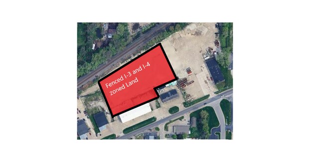
Property Record
5620 Massachusetts Ave, Indianapolis, IN 46218


NEARBY LISTINGS FOR SALE OR LEASE
Property Detail
5620 Massachusetts Ave
49-07-22-114-014.000-701
PT NW1/4 SE1/4 S22 T16 R4 BEG 774.56FT S & 472.06FTNE OF NW COR NE 249.05FT S 520.13FT SW 224.72FT N468.42FT TO BEG. 2.3578AC
Warehouse
Marion
X
Indiana
18097C0154G
2.36 AC
2023
Lawrence/East County
2024
Indianapolis
360102
Indianapolis-Carmel-Anderson, IN
9,100 SF
DEMOGRAPHICS near 5620 Massachusetts Ave
1 Mile
3 Mile
5 Mile
2024 Total Population
7,857
95,392
276,221
2029 Population
7,891
95,067
276,228
Pop Growth 2024-2029
+ 0.43%
(0.34%)
0.00%
Average Age
38
38
37
2024 Total Households
3,074
39,461
116,852
HH Growth 2024-2029
+ 0.39%
(0.45%)
(0.07%)
Median Household Inc
$28,323
$40,269
$48,544
Avg Household Size
2.40
2.30
2.30
2024 Avg HH Vehicles
1.00
1.00
1.00
Median Home Value
$71,745
$122,120
$172,333
Median Year Built
1958
1958
1958
Nearby Places
Map Layers
Map Styles
 Street
 Aerial
- Restaurants
- Banks
- Shops
- Fitness
- Groceries
PUBLIC TRANSPORTATION
COMMUTER RAIL
DRIVE
WALK
Distance
15 min
8.4 mi
AIRPORT
Indianapolis International
DRIVE
WALK
Distance
Indianapolis International
36 min
20.5 mi
Nearby Properties
Address
Land Use
TOTAL SIZE
Lot Size
Zoning
Address
Land Use
TOTAL SIZE
Lot Size
Zoning
25,146 SF
28.58 AC
ZO01
Address
Land Use
TOTAL SIZE
Lot Size
Zoning
143,890 SF
37.81 AC
ZO01
Address
Land Use
TOTAL SIZE
Lot Size
Zoning
866 SF
14.33 AC
ZO01
Address
Land Use
TOTAL SIZE
Lot Size
Zoning
6,000 SF
8.79 AC
ZO01
Address
Land Use
TOTAL SIZE
Lot Size
Zoning
4,588 SF
24.33 AC
ZO01
Address
Land Use
TOTAL SIZE
Lot Size
Zoning
2,142 SF
9.91 AC
ZO01
Address
Land Use
TOTAL SIZE
Lot Size
Zoning
713,497 SF
69.91 AC
ZO01
Address
Land Use
TOTAL SIZE
Lot Size
Zoning
5,670 SF
25.69 AC
Address
Land Use
TOTAL SIZE
Lot Size
Zoning
1,066 SF
24.93 AC
Address
Land Use
TOTAL SIZE
Lot Size
Zoning
118,126 SF
6.31 AC
ZO01
Address
Land Use
TOTAL SIZE
Lot Size
Zoning
1,768 SF
30.88 AC
ZO01
Address
Land Use
TOTAL SIZE
Lot Size
Zoning
925,384 SF
49.48 AC
ZO01
Address
Land Use
TOTAL SIZE
Lot Size
Zoning
150,929 SF
28.61 AC
ZO01
Address
Land Use
TOTAL SIZE
Lot Size
Zoning
167,808 SF
14.95 AC
ZO01
Address
Land Use
TOTAL SIZE
Lot Size
Zoning
268,930 SF
20.55 AC
ZO01
Address
Land Use
TOTAL SIZE
Lot Size
Zoning
66,953 SF
10.87 AC
ZO01
Address
Land Use
TOTAL SIZE
Lot Size
Zoning
4,692 SF
25.76 AC
Address
Land Use
TOTAL SIZE
Lot Size
Zoning
269,450 SF
5.85 AC
Address
Land Use
TOTAL SIZE
Lot Size
Zoning
1,865 SF
22.15 AC
ZO01
Address
Land Use
TOTAL SIZE
Lot Size
Zoning
8,054 SF
20.62 AC
Address
Land Use
TOTAL SIZE
Lot Size
Zoning
278,338 SF
14.80 AC
Address
Land Use
TOTAL SIZE
Lot Size
Zoning
206,080 SF
12.97 AC
ZO01
Address
Land Use
TOTAL SIZE
Lot Size
Zoning
175,046 SF
15.77 AC
ZO01
Address
Land Use
TOTAL SIZE
Lot Size
Zoning
254,641 SF
29.53 AC
Address
Land Use
TOTAL SIZE
Lot Size
Zoning
6,252 SF
17.02 AC
ZO01
Address
Land Use
TOTAL SIZE
Lot Size
Zoning
77,518 SF
11.69 AC
ZO01
Address
Land Use
TOTAL SIZE
Lot Size
Zoning
1,594 SF
6.47 AC
ZO01
Address
Land Use
TOTAL SIZE
Lot Size
Zoning
6.53 AC
ZO01
Address
Land Use
TOTAL SIZE
Lot Size
Zoning
23,686 SF
8.57 AC
ZO01
Address
Land Use
TOTAL SIZE
Lot Size
Zoning
3,004 SF
13.79 AC
The World's #1 Commercial Real Estate Marketplace
Connect with us
© 2026 CoStar Group
The information above has been obtained from sources believed reliable. While we do not doubt its accuracy we have not verified it and make no guarantee, warranty or representation about it. It is your responsibility to independently confirm its accuracy and completeness. Any projections, opinions, assumptions, or estimates used are for example only and do not represent the current or future performance of the property. The value of this transaction to you depends on tax and other factors which should be evaluated by your tax, financial, and legal advisors. You and your advisors should conduct a careful, independent investigation of the property to determine to your satisfaction the suitability of the property for your needs.