Property Record
5620 Mcfarland Blvd, Northport, AL 35476
Current Lease Availabilities
NEARBY LISTINGS FOR SALE OR LEASE
Property Detail
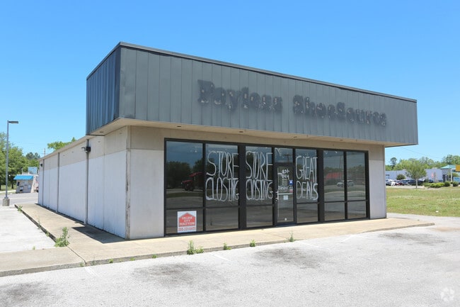
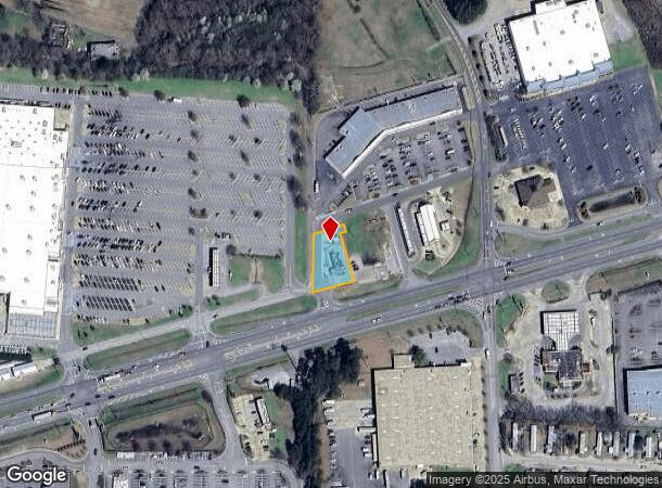
5620 Mcfarland Blvd
Tuscaloosa, AL
Hfs Corners
31-03-08-3-002-001.005
PART LOT 2 HFS CORNERS S/D DESC AS: BEG INT W LN SW1/4 S8 T21S R10W & N R/W HWY 82; N 176.4; NE 100; SE 20; SW 20; SE 150; SW 129 TO POB
Restaurantdrivein
Tuscaloosa
X
Alabama
01125C0501G
2
2025
0.41 AC
2024
Tuscaloosa
010304
Birmingham
768 SF
DEMOGRAPHICS near 5620 Mcfarland Blvd
1 Mile
3 Mile
5 Mile
2024 Total Population
3,152
24,120
82,278
2029 Population
3,568
27,193
92,315
Pop Growth 2024-2029
+ 13.20%
+ 12.74%
+ 12.20%
Average Age
39
40
35
2024 Total Households
1,190
9,386
30,270
HH Growth 2024-2029
+ 13.11%
+ 12.56%
+ 14.10%
Median Household Inc
$59,999
$62,009
$45,901
Avg Household Size
2.50
2.30
2.20
2024 Avg HH Vehicles
2.00
2.00
2.00
Median Home Value
$173,340
$190,997
$209,017
Median Year Built
1990
1983
1987
Nearby Places
- Restaurants
- Banks
- Shops
- Fitness
- Groceries
PUBLIC TRANSPORTATION
COMMUTER RAIL
DRIVE
WALK
Distance
10 min
5.1 mi
Nearby Properties
Address
Land Use
TOTAL SIZE
Lot Size
Zoning
Address
Land Use
TOTAL SIZE
Lot Size
Zoning
121,384 SF
21 AC
O-I
Address
Land Use
TOTAL SIZE
Lot Size
Zoning
174,000 SF
28.67 AC
R1
Address
Land Use
TOTAL SIZE
Lot Size
Zoning
173,452 SF
2.30 AC
ML
Address
Land Use
TOTAL SIZE
Lot Size
Zoning
26,576 SF
2.53 AC
RD
Address
Land Use
TOTAL SIZE
Lot Size
Zoning
15.30 AC
Address
Land Use
TOTAL SIZE
Lot Size
Zoning
361,935 SF
133.67 AC
MH
Address
Land Use
TOTAL SIZE
Lot Size
Zoning
301,560 SF
15 AC
ML
Address
Land Use
TOTAL SIZE
Lot Size
Zoning
73,848 SF
1.73 AC
BGO
Address
Land Use
TOTAL SIZE
Lot Size
Zoning
96,885 SF
2.34 AC
RD
Address
Land Use
TOTAL SIZE
Lot Size
Zoning
10,440 SF
12 AC
Address
Land Use
TOTAL SIZE
Lot Size
Zoning
32,640 SF
9.80 AC
C6
Address
Land Use
TOTAL SIZE
Lot Size
Zoning
143,038 SF
36 AC
O-I
Address
Land Use
TOTAL SIZE
Lot Size
Zoning
50,652 SF
19.03 AC
ML
Address
Land Use
TOTAL SIZE
Lot Size
Zoning
91,231 SF
7.71 AC
ML
Address
Land Use
TOTAL SIZE
Lot Size
Zoning
59,039 SF
1.35 AC
RD
Address
Land Use
TOTAL SIZE
Lot Size
Zoning
208,996 SF
25 AC
C-6
Address
Land Use
TOTAL SIZE
Lot Size
Zoning
140,412 SF
14.35 AC
C6
Address
Land Use
TOTAL SIZE
Lot Size
Zoning
213,549 SF
8.80 AC
ML
Address
Land Use
TOTAL SIZE
Lot Size
Zoning
211,838 SF
11.71 AC
ML
Address
Land Use
TOTAL SIZE
Lot Size
Zoning
176,846 SF
21.27 AC
ML
Address
Land Use
TOTAL SIZE
Lot Size
Zoning
108,000 SF
11.87 AC
Address
Land Use
TOTAL SIZE
Lot Size
Zoning
16,920 SF
6.84 AC
AG
Address
Land Use
TOTAL SIZE
Lot Size
Zoning
60,603 SF
0.85 AC
Address
Land Use
TOTAL SIZE
Lot Size
Zoning
13,800 SF
8.40 AC
C6
Address
Land Use
TOTAL SIZE
Lot Size
Zoning
8,160 SF
3.18 AC
MFH
Address
Land Use
TOTAL SIZE
Lot Size
Zoning
89,820 SF
5.33 AC
MH
Address
Land Use
TOTAL SIZE
Lot Size
Zoning
8,152 SF
18 AC
ML
Address
Land Use
TOTAL SIZE
Lot Size
Zoning
7,376 SF
10.50 AC
ML
Address
Land Use
TOTAL SIZE
Lot Size
Zoning
8,952 SF
5 AC
RM2
Address
Land Use
TOTAL SIZE
Lot Size
Zoning
11,244 SF
5.60 AC
RM2
The World's #1 Commercial Real Estate Marketplace
Connect with us
© 2025 CoStar Group
The information above has been obtained from sources believed reliable. While we do not doubt its accuracy we have not verified it and make no guarantee, warranty or representation about it. It is your responsibility to independently confirm its accuracy and completeness. Any projections, opinions, assumptions, or estimates used are for example only and do not represent the current or future performance of the property. The value of this transaction to you depends on tax and other factors which should be evaluated by your tax, financial, and legal advisors. You and your advisors should conduct a careful, independent investigation of the property to determine to your satisfaction the suitability of the property for your needs.