Property Record
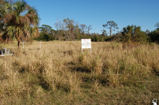
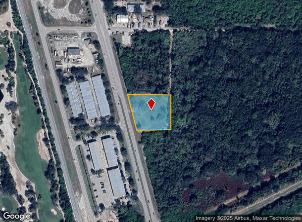
5620 Us Highway 1, Vero Beach, FL 32967

NEARBY LISTINGS FOR SALE OR LEASE
Property Detail
5620 Us Highway 1
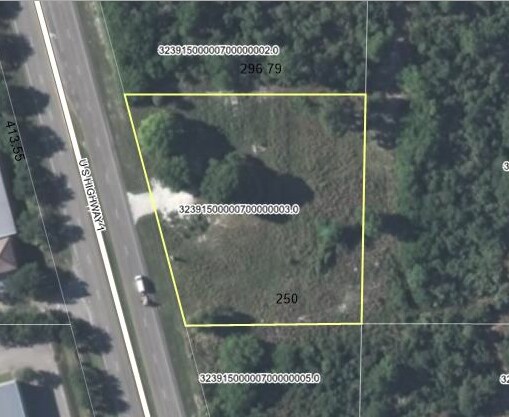
32-39-15-00000-7000-00003.0
Null
Commercialacreage
SEC 15 TWP 32 RNG 39 MORE FULLY DESC AS COM AT THE NE COR OF THE SE QTR OF SEC 15 TH RUN S01-48-31W ON THE SEC LINE A DIS OF 450 FT TO THE POB TH RUN S89-55-31W A DIS OF 296.79 FT TO THE E ROW LINE OF NEW US HWY 1 TH RUN S14-54-29E TO A POINT WHICH I
X
Indian River
12061C0233J
Florida
2025
1.54 AC
2025
Other Market Areas
050811
Sebastian-Vero Beach, FL
DEMOGRAPHICS near 5620 Us Highway 1
1 Mile
3 Mile
5 Mile
2024 Total Population
2,337
22,533
60,305
2029 Population
2,671
25,520
68,373
Pop Growth 2024-2029
+ 14.29%
+ 13.26%
+ 13.38%
Average Age
53
53
53
2024 Total Households
1,138
10,160
28,245
HH Growth 2024-2029
+ 13.97%
+ 13.04%
+ 13.14%
Median Household Inc
$68,840
$67,680
$62,769
Avg Household Size
2.00
2.10
2.00
2024 Avg HH Vehicles
2.00
2.00
2.00
Median Home Value
$350,000
$386,520
$376,669
Median Year Built
2005
2000
1991
Nearby Places
Map Layers
Map Styles
 Street
 Aerial
- Restaurants
- Banks
- Shops
- Fitness
- Groceries
SALE & LEASE HISTORY
LISTING DATE
SALE/LEASE

Sep 24, 2016
For Sale
May 23, 2018
For Sale
Feb 24, 2017
For Sale
Aug 21, 2017
For Lease
Nearby Properties
Address
Land Use
TOTAL SIZE
Lot Size
Zoning
Address
Land Use
TOTAL SIZE
Lot Size
Zoning
634,259 SF
53.45 AC
MED
Address
Land Use
TOTAL SIZE
Lot Size
Zoning
571,211 SF
26.38 AC
RM-10
Address
Land Use
TOTAL SIZE
Lot Size
Zoning
21,228 SF
145.79 AC
A-1
Address
Land Use
TOTAL SIZE
Lot Size
Zoning
240,516 SF
39.71 AC
RM-8
Address
Land Use
TOTAL SIZE
Lot Size
Zoning
2,133 SF
772.04 AC
ALI-A1
Address
Land Use
TOTAL SIZE
Lot Size
Zoning
46,567 SF
19.61 AC
CG
Address
Land Use
TOTAL SIZE
Lot Size
Zoning
12,151 SF
2.52 AC
R-1A
Address
Land Use
TOTAL SIZE
Lot Size
Zoning
100 SF
5.46 AC
R-1A
Address
Land Use
TOTAL SIZE
Lot Size
Zoning
124.80 AC
Address
Land Use
TOTAL SIZE
Lot Size
Zoning
235,921 SF
28.80 AC
RM-8
Address
Land Use
TOTAL SIZE
Lot Size
Zoning
67,334 SF
9.63 AC
MED
Address
Land Use
TOTAL SIZE
Lot Size
Zoning
8,087 SF
1.44 AC
R-1A
Address
Land Use
TOTAL SIZE
Lot Size
Zoning
4,364 SF
0.64 AC
R-1A
Address
Land Use
TOTAL SIZE
Lot Size
Zoning
91,904 SF
10 AC
CG
Address
Land Use
TOTAL SIZE
Lot Size
Zoning
29,804 SF
498.76 AC
CON-1
Address
Land Use
TOTAL SIZE
Lot Size
Zoning
9,118 SF
1.48 AC
R-1A
Address
Land Use
TOTAL SIZE
Lot Size
Zoning
5,524 SF
0.51 AC
R-1A
Address
Land Use
TOTAL SIZE
Lot Size
Zoning
1.30 AC
R-1A
Address
Land Use
TOTAL SIZE
Lot Size
Zoning
12,908 SF
1.26 AC
R-1A
Address
Land Use
TOTAL SIZE
Lot Size
Zoning
72,397 SF
10.45 AC
CG
Address
Land Use
TOTAL SIZE
Lot Size
Zoning
6,479 SF
1.31 AC
R-1A
Address
Land Use
TOTAL SIZE
Lot Size
Zoning
4,742 SF
38.96 AC
RS-6
Address
Land Use
TOTAL SIZE
Lot Size
Zoning
94,187 SF
9.15 AC
MED
Address
Land Use
TOTAL SIZE
Lot Size
Zoning
0.92 AC
R-2A
Address
Land Use
TOTAL SIZE
Lot Size
Zoning
6,898 SF
1.18 AC
R-1A
Address
Land Use
TOTAL SIZE
Lot Size
Zoning
1.03 AC
R-1A
Address
Land Use
TOTAL SIZE
Lot Size
Zoning
760 SF
6.05 AC
IL
Address
Land Use
TOTAL SIZE
Lot Size
Zoning
324 SF
5.40 AC
P
Address
Land Use
TOTAL SIZE
Lot Size
Zoning
1,152 SF
26.67 AC
IG
Address
Land Use
TOTAL SIZE
Lot Size
Zoning
70,663 SF
4.36 AC
RM-8
The World's #1 Commercial Real Estate Marketplace
Connect with us
© 2025 CoStar Group
The information above has been obtained from sources believed reliable. While we do not doubt its accuracy we have not verified it and make no guarantee, warranty or representation about it. It is your responsibility to independently confirm its accuracy and completeness. Any projections, opinions, assumptions, or estimates used are for example only and do not represent the current or future performance of the property. The value of this transaction to you depends on tax and other factors which should be evaluated by your tax, financial, and legal advisors. You and your advisors should conduct a careful, independent investigation of the property to determine to your satisfaction the suitability of the property for your needs.