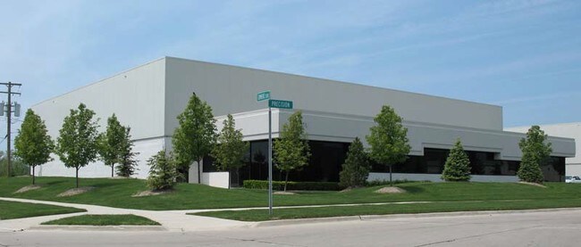
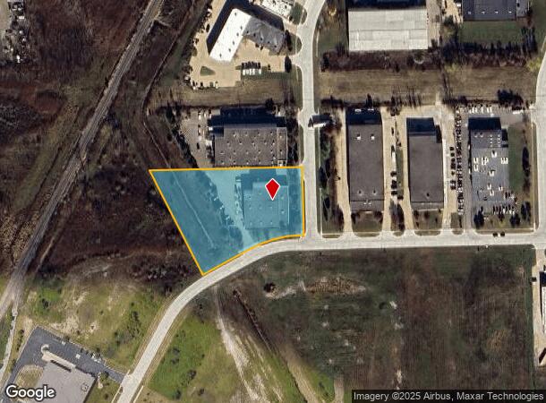
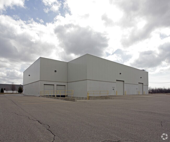
Property Record
56201 Precision Dr, Chesterfield, MI 48051
NEARBY LISTINGS FOR SALE OR LEASE
Property Detail
56201 Precision Dr
Detroit-Warren-Dearborn, MI
North Bay No 2
15-09-04-101-003
NORTH BAY PARK OF INDUSTRY #2 LIBER 116 PAGES 19 THRU 23 LOT 14
Lightindustrial
Macomb
X
Michigan
26099C0258G
14
2024
2.61 AC
2025
Groesbeck North
221500
Detroit
17,550 SF
DEMOGRAPHICS near 56201 Precision Dr
1 Mile
3 Mile
5 Mile
2024 Total Population
783
31,369
71,845
2029 Population
772
31,405
71,633
Pop Growth 2024-2029
(1.40%)
+ 0.11%
(0.30%)
Average Age
41
38
41
2024 Total Households
283
11,541
27,161
HH Growth 2024-2029
(1.41%)
+ 0.20%
(0.27%)
Median Household Inc
$108,928
$75,671
$80,067
Avg Household Size
2.70
2.60
2.50
2024 Avg HH Vehicles
2.00
2.00
2.00
Median Home Value
$273,423
$240,751
$255,949
Median Year Built
1999
1998
1994
Nearby Places
Map Layers
Map Styles
 Street
 Aerial
- Restaurants
- Banks
- Shops
- Fitness
- Groceries
PUBLIC TRANSPORTATION
AIRPORT
Windsor International
DRIVE
WALK
Distance
Windsor International
69 min
44.0 mi
SALE & LEASE HISTORY
LISTING DATE
SALE/LEASE

Sep 12, 2017
For Sale
Sep 11, 2017
For Sale
Jul 28, 2017
For Lease
Nearby Properties
Address
Land Use
TOTAL SIZE
Lot Size
Zoning
Address
Land Use
TOTAL SIZE
Lot Size
Zoning
808,240 SF
60.31 AC
RM 3 MU
Address
Land Use
TOTAL SIZE
Lot Size
Zoning
Address
Land Use
TOTAL SIZE
Lot Size
Zoning
181,094 SF
14.89 AC
C3 GEN
Address
Land Use
TOTAL SIZE
Lot Size
Zoning
316,907 SF
21.18 AC
M2 GEN
Address
Land Use
TOTAL SIZE
Lot Size
Zoning
124,956 SF
15.78 AC
C2 SHO
Address
Land Use
TOTAL SIZE
Lot Size
Zoning
204,318 SF
27.75 AC
C3 GEN
Address
Land Use
TOTAL SIZE
Lot Size
Zoning
179,250 SF
26.35 AC
M2 GEN
Address
Land Use
TOTAL SIZE
Lot Size
Zoning
5,541 SF
130.51 AC
MHP MO
Address
Land Use
TOTAL SIZE
Lot Size
Zoning
72,184 SF
69.68 AC
M2 GEN
Address
Land Use
TOTAL SIZE
Lot Size
Zoning
156,262 SF
16.23 AC
RM2 MU
Address
Land Use
TOTAL SIZE
Lot Size
Zoning
179,200 SF
10.12 AC
RT TECH
Address
Land Use
TOTAL SIZE
Lot Size
Zoning
52,375 SF
RM 3 MU
Address
Land Use
TOTAL SIZE
Lot Size
Zoning
117,374 SF
12.95 AC
C2 SHO
Address
Land Use
TOTAL SIZE
Lot Size
Zoning
41,125 SF
3.55 AC
RM 3 MU
Address
Land Use
TOTAL SIZE
Lot Size
Zoning
3,799 SF
56.46 AC
MH
Address
Land Use
TOTAL SIZE
Lot Size
Zoning
100,259 SF
8.80 AC
C2 SHO
Address
Land Use
TOTAL SIZE
Lot Size
Zoning
26,578 SF
31.52 AC
IR
Address
Land Use
TOTAL SIZE
Lot Size
Zoning
62,624 SF
5.92 AC
RM2 MU
Address
Land Use
TOTAL SIZE
Lot Size
Zoning
Address
Land Use
TOTAL SIZE
Lot Size
Zoning
88,116 SF
5.66 AC
IO
Address
Land Use
TOTAL SIZE
Lot Size
Zoning
25,963 SF
15.97 AC
M2 GEN
Address
Land Use
TOTAL SIZE
Lot Size
Zoning
30,878 SF
5.32 AC
IO
Address
Land Use
TOTAL SIZE
Lot Size
Zoning
67,980 SF
8.23 AC
M2 GEN
Address
Land Use
TOTAL SIZE
Lot Size
Zoning
55,821 SF
M2 GEN
Address
Land Use
TOTAL SIZE
Lot Size
Zoning
58,392 SF
3.66 AC
M1 LIG
Address
Land Use
TOTAL SIZE
Lot Size
Zoning
70,070 SF
21.41 AC
RT TECH
Address
Land Use
TOTAL SIZE
Lot Size
Zoning
82,370 SF
19.14 AC
M2 GEN
Address
Land Use
TOTAL SIZE
Lot Size
Zoning
19,280 SF
3.97 AC
M2 GEN
Address
Land Use
TOTAL SIZE
Lot Size
Zoning
85,097 SF
4.87 AC
M2 GEN
Address
Land Use
TOTAL SIZE
Lot Size
Zoning
27,027 SF
15.71 AC
C3 GEN
The World's #1 Commercial Real Estate Marketplace
Connect with us
© 2025 CoStar Group
The information above has been obtained from sources believed reliable. While we do not doubt its accuracy we have not verified it and make no guarantee, warranty or representation about it. It is your responsibility to independently confirm its accuracy and completeness. Any projections, opinions, assumptions, or estimates used are for example only and do not represent the current or future performance of the property. The value of this transaction to you depends on tax and other factors which should be evaluated by your tax, financial, and legal advisors. You and your advisors should conduct a careful, independent investigation of the property to determine to your satisfaction the suitability of the property for your needs.