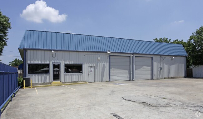
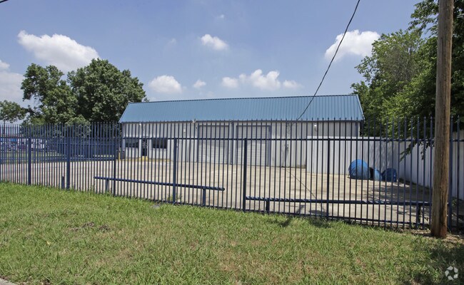
Property Record
5621 Main St, Watauga, TX 76148


Property Detail
5621 Main St
Dallas-Fort Worth-Arlington, TX
WATAUGA ADDITION BLOCK 10 LOT 9R
40989127
Tarrant
Commercialnec
Texas
B and X Area of moderate flood hazard, usually the area between the limits of the 100-year and 500-year floods.
9r
2023
0.34 AC
2025
Watauga/Keller/NRH
113810
Dallas/Ft Worth
7,784 SF
NEARBY LISTINGS FOR SALE OR LEASE
DEMOGRAPHICS near 5621 Main St
1 mile
3 mile
5 mile
2025 Total Population
17,019
137,583
303,042
2030 Population
17,761
143,765
317,363
Pop Growth 2025-2030
+ 4.36%
+ 4.49%
+ 4.73%
Average Age
37
38
38
2025 Total Households
5,514
50,952
108,918
HH Growth 2025-2030
+ 4.46%
+ 4.66%
+ 4.94%
Median Household Inc
$85,103
$83,846
$89,130
Avg Household Size
3.00
2.70
2.70
2025 Avg HH Vehicles
2.00
2.00
2.00
Median Home Value
$252,241
$297,663
$329,566
Median Year Built
1985
1989
1992
Nearby Places
Map Layers
Map Styles
 Street
 Aerial
Layers
 Traffic
 Biking
Places
Listings with unknown addresses are not visible on the map
- Restaurants
- Banks
- Shops
- Fitness
- Groceries
PUBLIC TRANSPORTATION
COMMUTER RAIL
Drive
Walk
Distance
12 min
7.1 mi
AIRPORT
Dallas-Fort Worth International
Drive
Walk
Distance
Dallas-Fort Worth International
28 min
19.8 mi
Dallas Love Field
Drive
Walk
Distance
Dallas Love Field
39 min
28.5 mi
Nearby Properties
Address
Land Use
TOTAL SIZE
Lot Size
Zoning
Address
Land Use
TOTAL SIZE
Lot Size
Zoning
547,836 SF
2 AC
Address
Land Use
TOTAL SIZE
Lot Size
Zoning
332,094 SF
19.33 AC
Address
Land Use
TOTAL SIZE
Lot Size
Zoning
473,562 SF
24.63 AC
Address
Land Use
TOTAL SIZE
Lot Size
Zoning
352,354 SF
17.02 AC
Address
Land Use
TOTAL SIZE
Lot Size
Zoning
381,000 SF
8.74 AC
Address
Land Use
TOTAL SIZE
Lot Size
Zoning
350,153 SF
19.73 AC
Address
Land Use
TOTAL SIZE
Lot Size
Zoning
433,894 SF
18.99 AC
Address
Land Use
TOTAL SIZE
Lot Size
Zoning
385,697 SF
15.94 AC
Address
Land Use
TOTAL SIZE
Lot Size
Zoning
810,978 SF
45.84 AC
Address
Land Use
TOTAL SIZE
Lot Size
Zoning
327,325 SF
16.87 AC
Address
Land Use
TOTAL SIZE
Lot Size
Zoning
285,672 SF
19.20 AC
Address
Land Use
TOTAL SIZE
Lot Size
Zoning
278,292 SF
16.35 AC
Address
Land Use
TOTAL SIZE
Lot Size
Zoning
344,992 SF
17.49 AC
Address
Land Use
TOTAL SIZE
Lot Size
Zoning
312,219 SF
17.82 AC
Address
Land Use
TOTAL SIZE
Lot Size
Zoning
248,993 SF
15.40 AC
Address
Land Use
TOTAL SIZE
Lot Size
Zoning
263,411 SF
7.32 AC
Address
Land Use
TOTAL SIZE
Lot Size
Zoning
368,751 SF
19.97 AC
Address
Land Use
TOTAL SIZE
Lot Size
Zoning
293,972 SF
17.30 AC
Address
Land Use
TOTAL SIZE
Lot Size
Zoning
301,972 SF
19.32 AC
Address
Land Use
TOTAL SIZE
Lot Size
Zoning
266,403 SF
16.67 AC
Address
Land Use
TOTAL SIZE
Lot Size
Zoning
270,394 SF
16.43 AC
Address
Land Use
TOTAL SIZE
Lot Size
Zoning
359,411 SF
17.77 AC
Address
Land Use
TOTAL SIZE
Lot Size
Zoning
296,724 SF
17.58 AC
Address
Land Use
TOTAL SIZE
Lot Size
Zoning
261,579 SF
30.93 AC
Address
Land Use
TOTAL SIZE
Lot Size
Zoning
304,361 SF
7.13 AC
Address
Land Use
TOTAL SIZE
Lot Size
Zoning
241,064 SF
12.63 AC
Address
Land Use
TOTAL SIZE
Lot Size
Zoning
307,568 SF
13.13 AC
Address
Land Use
TOTAL SIZE
Lot Size
Zoning
238,120 SF
13.03 AC
Address
Land Use
TOTAL SIZE
Lot Size
Zoning
248,166 SF
12.05 AC
Address
Land Use
TOTAL SIZE
Lot Size
Zoning
191,534 SF
10.88 AC
The World's #1 Commercial Real Estate Marketplace
Connect with us
© 2026 CoStar Group
The information above has been obtained from sources believed reliable. While we do not doubt its accuracy we have not verified it and make no guarantee, warranty or representation about it. It is your responsibility to independently confirm its accuracy and completeness. Any projections, opinions, assumptions, or estimates used are for example only and do not represent the current or future performance of the property. The value of this transaction to you depends on tax and other factors which should be evaluated by your tax, financial, and legal advisors. You and your advisors should conduct a careful, independent investigation of the property to determine to your satisfaction the suitability of the property for your needs.